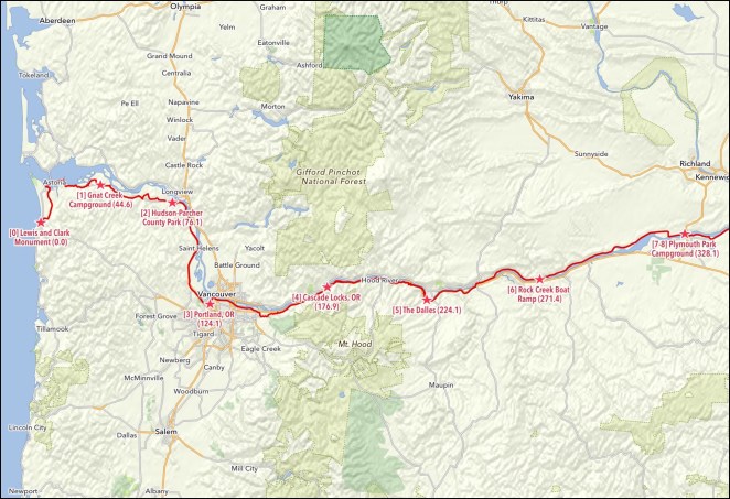
 Well, this is pretty bass-ackwards. My intention had been to write a week–by-week preview every Saturday during Side2Side- a little taste of the things to come over the next seven days.

But last Saturday got crazy, because I was dealing with, well… stuff. We’ll leave it at that but, as you probably now know, the next day I was off and on my way.
 So you also know, from my last substantive post here, that I performed the obligatory wheel dip in the Pacific. And, if you’ve kept up with me on my facebook page, or are a member of one of a number of bicycling groups of which I am a member there, you likely also know that I’m writing this from a campground just outside the agricultural hamlet of Plymouth, Washington, several hundred miles up the Columbia River.

 What follows is how, as if i had written this last Saturday, I planned to get from there to here. I’m pleased, as an aside, to be able to say, with the benefit now of 20/20 hindsight, that my planned itinerary has worked quite well. Quite a few folks questioned the wisdom of doing all of the planning I did in the months that led up to Side2Side. I was told everything from, “It’ll have been a waste of time from the first day that things fall apart” to “You’ve sucked all the spontaneity and sense of adventure out of your trip.” Well, we’ll see. There’s close to 14 weeks left for those things to happen, but there’s no sign of either so far. I’ve said it over and over again and I’ll say it here, too. I’m doing this trip the way that works for me. I love having input, tips and suggestions from folks. Sometimes I even do the things that are recommended to me. But, if I don’t, please understand that I’m riding my own ride here. It may not look, sound or seem like the one you’d make if you were wearing my bicycle shoes. But I’m OK with that and I hope that you are, too.
 Oh, and for those of you waiting for those promised daily posts with pictures- they’ll (hopefully) all be up later today. So it’s all good. Thanks for hanging in there.
Side2Side Week 1 – June 23 to June 29, 2019

Total miles: 328.1
Road miles: 285.9
Bike path/trail miles: 42.2
Gravel miles (both road and path/trail): 8.1
Riding days: 7
Rest/Slack days: 0
Average distance per riding day: 46.9
Estimated elevation gain in feet: 14,006
Average estimated elevation gain in feet per day: 2,001
Nights camping: 5 (n.b. turned out to be 4)
Nights hosted: 1
Nights hotel/motel: 1 (n.b. turned out to be 2)
Major things to see: Lewis and Clark Monument, Fort Clatsop, Megler-Astoria Bridge, Bradley State Scenic Viewpoint (Clatsop Crest), Portland, Oregon, Columbia River Gorge, Portland Women’s Forum State Scenic Overlook, Vista House, Multnomah Falls, Bonneville Dam, Bridge of the Gods, Mosier Twin Tunnels, Rowena Crest Overlook, The Dalles Dam, John Day Dam
Day 1 – Sunday, June 23, 2019 – Seaside, Oregon to Gnat Creek Campground, Oregon

Cumulative miles: 44.6
Day’s miles: 44.6
Road miles: 37.8
Bike path/trail miles: 6.8
Gravel miles (both road and path/trail): 2.1
Day’s estimated elevation gain in feet: 2,502
Overnight accomodation type: Camping
Cities and towns on route: Seaside, OR, Astoria, OR,
Major things to see: Lewis and Clark Monument, Fort Clatsop, Megler-Astoria Bridge
General description of route: Leave Seaside, OR on local roads to east, then head north on private (logging company) “Lewis and Clark Mainline” road, return to local roads near Astoria, OR, stop at Fort Clatsop (Lewis and Clark site), take “Dike Trail” around Astoria Airport, cross Youngs Bay on U.S. Route 101, follow Riverfront Bike Path through Astoria, take U.S Route 30 and parallel local roads east to Gnat Creek Campground, OR
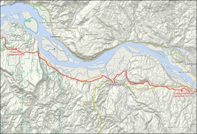
Day 2 – Monday, June 24, 2019 – Gnat Creek Campground, Oregon to Hudson-Parcher County Park, Oregon

Cumulative miles: 76.1
Day’s miles: 31.5
Road miles: 31.5
Bike path/trail miles: 0
Gravel miles (both road and path/trail): 0
Day’s estimated elevation gain in feet: 1,432
Overnight accomodation type: Camping
Cities and towns on route: Westport, OR, Clatskanie, OR,
Major things to see: Bradley State Scenic Viewpoint (Clatsop Crest)
General description of route: Take U.S Route 30 and parallel local roads east from Gnat Creek Campground, OR to Hudson-Parcher County Park, OR
Day 3 – Tuesday, June 25, 2019 – Hudson-Parcher County Park, Oregon to Portland, Oregon

Cumulative miles: 124.1
Day’s miles: 48.0
Road miles: 48.0
Bike path/trail miles: 0
Gravel miles (both road and path/trail): 0
Day’s estimated elevation gain in feet: 1,336
Overnight accomodation type: Host
Cities and towns on route: Prescott, OR, Goble, OR, Deer Island, OR, Columbia City, OR, St. Helens, OR, Scappoose, OR, Burlington, OR, Portland, OR
Major things to see: Portland, OR
General description of route: Take local roads east from Hudson-Parcher County Park, OR to U.S. Route 30. Turn to the south on Route 30 along the Columbia River, then follow it and parallel local roads into the Portland metro area. Take St. Johns Bridge across the Willamette River and the city streets to the host’s residence in Portland.
Day 4 – Wednesday, June 26, 2019 – Portland, Oregon to Marine Park Campground

Cumulative miles: 176.9
Day’s miles: 52.8
Road miles: 52.8
Bike path/trail miles: 18.9
Gravel miles (both road and path/trail): 0
Day’s estimated elevation gain in feet: 1,575
Overnight accomodation type: Camping (n.b. became motel)
Cities and towns on route: Portland, OR, Gresham, OR, Fairview, OR, Troutdale, OR, Springdale, OR, Corbett, OR Cascade Locks, OR
Major things to see: Portland, Oregon, Columbia River Gorge, Portland Women’s Forum State Scenic Overlook, Vista House, Multnomah Falls, Bonneville Dam, Bridge of the Gods
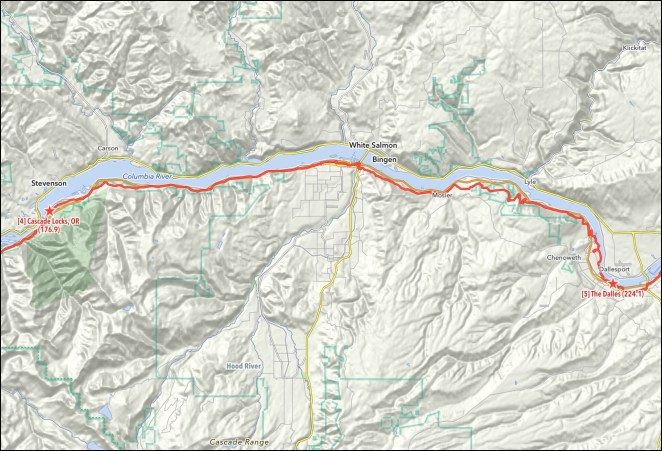
General description of route: Ride north from host’s home on city streets to the Slough bike trail, reaching the Columbia River at Marine Drive. Turn east onto the bike trail that intermittently parallels Marine Drive and take it and Marine Drive past the Portland International Airport through Gresham and Fairview, OR to Troutdale, OR. Continue east on the Columbia River Highway through Troutdale, then start into the Columbia River Gorge area on the Historic Columbia River Highway, following it through Springdale and Corbett, OR and past the Portland Women’s Forum State Scenic Overlook, Vista House and Multnomah Falls. The Historic Columbia River Highway becomes the Historic Columbia River Highway State Trail at the Yeon Trailhead and it is followed east along the Columbia River past Bonneville Dam into Cascade Locks, OR and the overnight at Marine Park Campground
Day 5 – Thursday, June 27, 2019 – Marine Park Campground, Oregon to The Dalles, Oregon

Cumulative miles: 224.1
Day’s miles: 47.2
Road miles: 33.8
Bike path/trail miles: 13.4
Gravel miles (both road and path/trail): 0
Day’s estimated elevation gain in feet: 3,046
Overnight accomodation type: Motel
Cities and towns on route: Cascade Locks, OR, Hood River, OR, Mosier, OR, The Dalles, OR
Major things to see: Mosier Twin Tunnels, Rowena Crest Overlook
General description of route: Leave Cascade Locks following Interstate Highway 84/ U.S Route 30 and parallel local roads east toward Hood River, OR. Follow the Historic Columbia River Highway Trail along the Interstate for a brief stretch. Take local roads into and through Hood River, then resume riding on the trail starting at the Hatfield Trailhead and following it through the Mosier Twin Tunnels. The trail segment ends and the Historic Columbia River Highway is then followed through Mosier and past the Rowena Crest Viewpoint to the outskirts of The Dalles. The Riverfront Trail begins here and is followed to the center of the city.
Day 6 – Friday, June 28, 2019 – The Dalles, Oregon to Rock Creek Boat Landing, Washington

Cumulative miles: 271.4
Day’s miles: 47.3
Road miles: 47.3
Bike path/trail miles: 0
Gravel miles (both road and path/trail): 0.5
Day’s estimated elevation gain in feet: 2,156
Overnight accomodation type: Camping
Cities and towns on route: The Dalles, OR, Biggs Junction, OR, Maryhill, WA
Major things to see: The Dalles Dam, John Day Dam
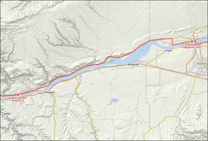
General description of route: Leave the Dalles, OR on the Riverfront bike path, then follow U.S. Route 30 east to its junction with U.S. Route 197, then follow Routes 30-197 north to a continuation of the Riverfront bike path past John Day Dam, then turn onto Interstate Route 84/Route 30 east, exiting at the Oregon State Highway 206 exit, then follow OR 206 to Biggs Junction, then turn north on U.S. Route 97 and cross the Columbia River into Washington, then turn east after the bridge onto Maryhill Road and take that road east past John Day Dam to Washington State Highway 14, then take WA 14 east along the Columbia River to the Rock Creek Boat Landing.
Day 7 – Saturday, June 29, 2019 – Rock Creek Boat Landing, Washington to Plymouth Park Campground, Washington

Cumulative miles: 328.1
Day’s miles: 56.7
Road miles: 56.7
Bike path/trail miles: 0
Gravel miles (both road and path/trail): 0.5
Day’s estimated elevation gain in feet: 1,959
Overnight accomodation type: Camping
Cities and towns on route: Paterson, WA, Plymouth, WA
Major things to see: None noted
General description of route: Take Washington State Highway 14 east from Rock Creek Boat Landing to just before entering Plymouth, WA, then local roads to Plymouth Park Campground, WA
Wow – you amaze with every day you complete.
LikeLike
Double Dam Friday. Has a nice ring to it.
LikeLike
Well I’d say that the person doing the pedaling gets to decide how the trip is pedaled.
I do like the summaries and I really like the maps.
LikeLike