If I Ran Things at the National Park Service (Natchez Trace Parkway Edition)…

I’ll post these without editorial comment for now, and revisit them in the future. What do you think?

I would immediately:

1. Reduce the speed limit on the Trace to 35 miles/55 km per hour in the Nashville, Tupelo, Jackson, and Natchez areas, and to 40 miles/65 km per hour everywhere else.

2. Aggressively enforce lowered speed limits through use of technologies such as photo radar and through high ($300 and up) fines imposed on violators.

3. Establish a $50 permit good for 30 days of travel on the Trace from the date activated for all vehicular and bicycle users.

4. Dedicate all user fees produced by the sale of permits to maintenance of and upgrades to the Trace and do not reduce regular budget allocation based on their receipt.

5. Implement all other reasonable strategies intended to remove locally generated motor vehicle traffic from the Trace, to include high fines ($1,000 and up) for persons operating vehicles without a valid permit.

6. Regrade and repave the entire NTP to add 12 inch/30 cm paved shoulder outside the roadway edge white lines or, alternatively, reduce current 12 foot/3.6 meter lane width to 11 feet/3.3 meters by restriping to create said shoulder.

7. Begin immediate purchase of viewshed easements along the Trace with early priority given to “path of growth” and high visual quality areas.

8. Establish designated bicycle camping areas at existing waysides with restrooms no further than 30 miles/50 kilometers apart.

9. Remove all “modern” wayside and point of interest place name and informational signage and replace with “traditional” NTP signage wherever possible.

10. Rebuild, refurbish or restore as appropriate deteriorated Trace amenities such as nature trails, split rail fencing, interpretive signboards, picnic tables and the like.

David Edgren
April, 2018
Natchez, Mississippi

Due to Technical Difficulties…

It has just been impossible between bad and no wi-fi to post to my blog regularly during my Natchez Trace ride. The pics are the big problem. So, in the interim- I’m hoping to have access to a computer in Natchez- here’s my Facebook page.

David Edgren

I generally have a post or two a day there letting you know where I am. Thanks for following along.

Hills, Urrgh!

Before I do a long distance ride I plan pretty extensively. For the Trace I went to the extent of developing a narrative elevation profile for each day. Here’s the one for the first day out.

Starting from the Northern Terminus (mile 444/445) the NTP climbs sharply to the top of Backbone Ridge, where an initial crest of 886 ft is reached at mile 440.9/443.6. The NTP runs along the ridgeline, climbing slightly, and reaches a crest of 930 ft at mile 439.6/442.3, the start of the descent to Birdsong Hollow and the Double Arch Bridge over Little East Fork and TN SR 96. The bridge, reached at mile 438.1/440.8, has a height of 145 feet above the 650 foot valley floor. At the southern end of the Double Arch Bridge the NTP climbs back up onto Backbone Ridge and reaches a crest of 927 ft at mile 436.8/439.5. The NTP runs along the ridgeline for five miles rolling up and down, often sharply, before reaching a final crest on Backbone Ridge of 929 ft at mile 431.8/434.5. The NTP makes a steep descent to cross Dobbins Branch running in Pewitt Hollow at mile 430.7/433.4 then climbs sharply to a 809 ft saddle between two hills at mile 430.1/432.8 above the village of Leipers Fork, Tennessee to the east. Th NTP drops in a steep descent from the saddle and crosses Wilkie Branch (mile 429.6/432.3) and Pinewood Branch (mile 429.2/431.9), then climbs to an 849 ft crest at mile 428.3/431. From the crest the NTP descends steeply to cross Garrison Creek at mile 427.5/430.2 then climbs onto a ridge, reaching a crest of 904 ft at mile 426.1/428.8. The NTP makes a quick descent to the headwaters of Burns Branch (mile 425.4/427.9) then climbs above the 1,000 ft contour interval to a crest of 1,017 ft and the ridgeline of the Duck River Ridge at mile 423.1/425.8, which marks the northern Tennessee Valley Divide in this area. From this crest the NTP makes a brief steep descent then rolls along the ridgeline for seven and a half miles skirting the north side of Vestal Hill at mile 420/422.7. The NTP reaches an 895 ft crest at the eastern end of Lick Ridge at mile 414.8/417.5 then descends gently along Akin Ridge, leaving the ridge at mile 410.3/413 to descend into the valley of the Duck River. The exit to Tennessee State Route 50 is reached at mile 407.8/410.5 just before the Duck River Bridge.

Estimated difficulty score: 1130.1 – Per mile: 25.4

The NTP mileposts are shown in bold, and actual mileage after the slash. I’ve found this narrative to be almost uncannily accurate as I’ve been riding along, and it has been great to know the names of creeks and streams and other physical points of interest that I’ve passed. The “Estimated Difficulty Score” is my own personal formula that takes into account the grade and length of hills, the total distance covered and some other variables that allow me to grade and compare days by how high they score. The range for the Trace is about 60 down to around 5, with 10 or so being an average day and anything above 20 being really challenging.

I journal all this on crazyguyonabike. The first day is here:

NTP Day 01 – NT to TN SR 50 Bicycle Campground

You can link to other days from there if you are interested. Thanks for following along while I ride the Natchez Trace.

The Natchez Trace Parkway is 444 Miles Long, Right?

Nope. It isn’t. And that’s despite the National Park Service’s claim that 444 miles/714.5 kilometers is the “official length” of the Trace. In actuality, the Natchez Trace is 445.1 miles/716.3 kilometers long. Not to sound paranoid, but the government is not telling the truth here.

ezgif.com-crop

Maybe it’s because the last two sections of the Trace- the final eight miles or so to the Southern Terminus (“ST”) at Liberty Road in Natchez and the 14.3 miles/23 kilometers around the northwest quadrant of Jackson, Mississippi- were built many years after the majority of the remainder of the NTP, but there is a significant discrepancy between the official mile markers, which are supposed to reflect the actual distance measured from the ST to any given point along the Trace, and the true actual distance to any given point. How do I know the “actual” distance? By creating a GPX track based on Google Maps’ satellite view images of the NTP starting at the centerpoint of the bridge over Liberty Road, which I use as the ST, and ending at the centerpoint of the bridge over Tennessee State Route 100 near Nashville, which is the Northern Terminus (“NT), that’s how. This generates, when imported into a mapping program that calculates distance- I use Ride with GPS- a distance of 445 miles/716 kilometers (and, as noted above, a tiny bit of mileage “change,” but that doesn’t affect any of the distance measurements in between).

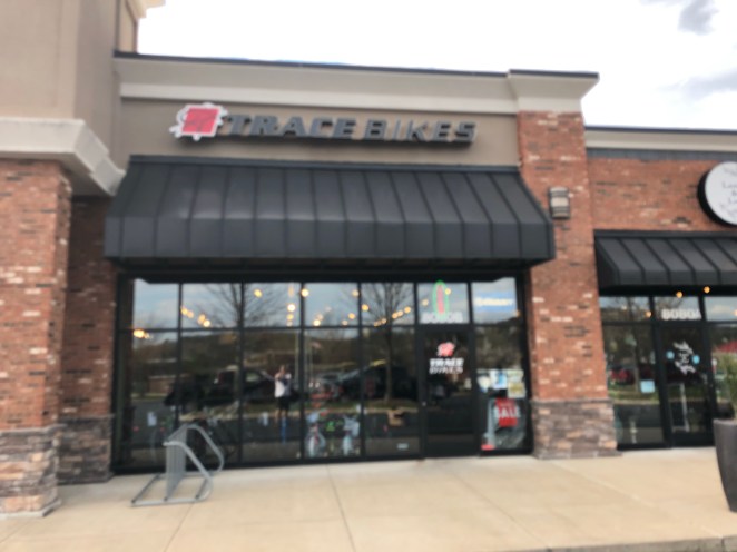
Now, before you say that the GPX track that was originally created just runs along wherever the program used “thinks” the centerline of the roadway is and this can be (and often, in my experience is) pretty inaccurate, let me tell you that I spent the better part of three work days placing the track right on the centerline as shown by the aerial image displayed in Google Maps, correcting by hand as I went along. I will acknowledge that this might have possibly introduced some error as to the total length of the track, but assert, after many years of creating route maps and associated data, that this would be at most a couple of tenths of a mile/kilometer over the entire length of the Trace. So I’m sure that you’re now wondering, “How actually bad is this discrepancy?” I mean, if I’m making a big deal out of a mile or so, does it really matter? Well, it is worse than just a mile difference (as if that isn’t bad enough to offend my cartographer’s eye), and I do think that it makes things pretty frustrating for folks who do things like prepare and use cue sheets based on GPX tracks, or go by mileage between points taken from a cycle computer. I like to preplan my trips with a pretty concrete idea of what my daily mileage is going to be, and an issue like this makes it just about impossible to get those figures easily. Now, also as noted above, the National Park Service in its literature describing the NTP says that it is 444 miles/714.5 kilometers in length. I’ve come up with just a tiny bit over 445 miles/716 kilometers. Again, then- what’s the problem? Well, bluntly put, the Park Service is pulling your leg with that number. Here’s why: The yellow star in the following photo diagram is the exact location of NTP milepost 442.

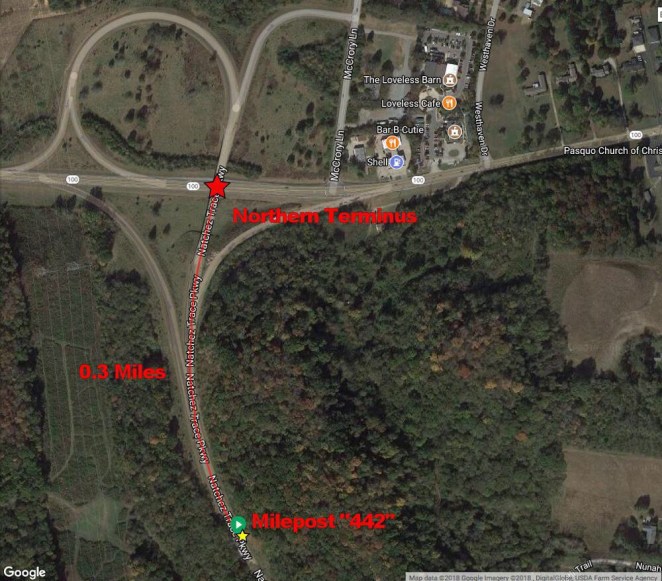
I have ridden my bicycle past this milepost as recently as Wednesday of this week, but if you want to verify where it is for yourself if you don’t believe me it is easily visible on the Google maps “street view.” From there headed to the red star at the center of the Tennessee State Route 100 bridge the distance is three-tenths of a mile/one-half a kilometer. Even if you include the additional distance around the longest northbound exit ramp (to westbound Route 100, you only come up with a total of seven-tenths of a mile/1.1 kilometers. It is thus, based on the location of Milepost 442, impossible to travel 444 miles on the Natchez Trace, much less 445 miles. Others have also spotted this problem [link].

But what about the other end, you might ask? Wouldn’t it be possible to find the additional mileage there just in case I located the Southern Terminus in the wrong place?

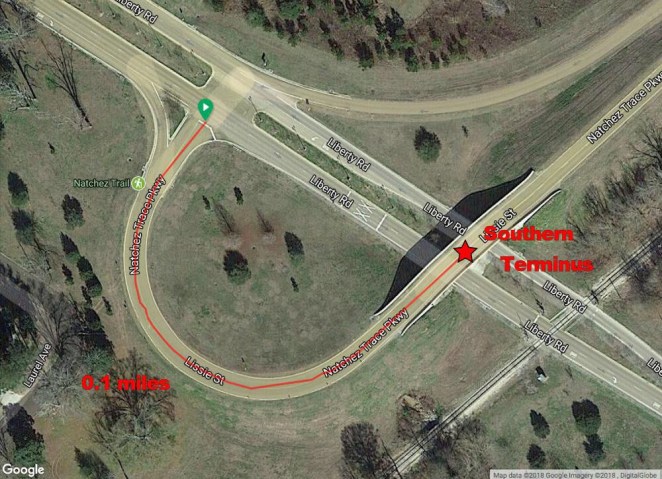
Well, woo hoo! A whole one-tenth of a mile/160 meters. So nope, it’s not there. There might be a little bit better case for adding in that tenth of a mile, but I need to draw my line from somewhere to somewhere, and I just don’t see a reason to include entrance/exit ramps. So that’s why I plotted my centerline distance that became my GPX track from the middle of the Liberty Road Bridge to the middle of the Tennessee Route 100 Bridge. But it gets worse than the Park Service pretending that the NTP is 444 miles long when, using its own measurements and mileposts, it can not possibly be any longer than, at the most (in other words, including the ramps), 442.8 miles/712.6 kilometers. By my measurement using the GPX track I created from the centerline shown on the aerial imagery, Milepost 442 is just a little less than 444.8 miles/715.8 kilometers from the Southern Terminus. That’s a difference of 2.8 miles/4.5 kilometers. This makes me think that the Park Service is aware of the discrepancy and pulled the “444 mile” distance out of thin air (uh-huh, thin air, that’s the ticket) as a way to cover itself just a little in reducing the gap.

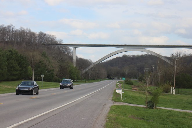
But maybe the Milepost 442 post is just mistakenly located. Well, that doesn’t fly. either. Here’s a chart showing the Trace mileposts at 100 mile intervals along with the actual mileage to each from the Southern Terminus.

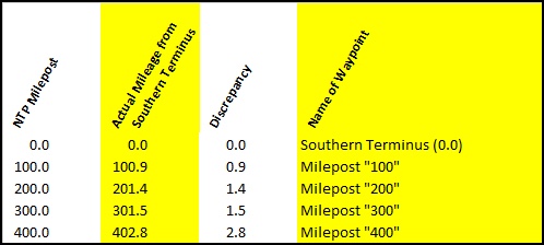
I have looked at every mileage number that the NPS has published for various locations along the Trace and compared them with the actual location plotted on the GPX track.

As you can see, the discrepancy increases fairly consistently as you head north. The NTP mileposts and published mileage numbers, in short, are not correct. None of them. And that’s a fact.

So what does this all mean in the overall scheme of things?  Does it make everything confusing?  Will I wind up missing seeing stuff because of the discrepancy?  No, almost certainly not.  When I figure distances and use my Ride with GPS app while I ride, I’ll use the “correct” mileage that the GPX track gives me.  When I post here, though, unless the difference is somehow significant to that situation in particular I’ll use the NTP milepost mileage.  Trust me, unlike the government I’ll keep you on track.

Transiting Nashville

I made it into Nashville just as planned and found myself out in the airport pickup zone with my bike and gear waiting for Steve, a friend met on one of the Facebook bicycling groups I hang out in, to come by in his truck and take me over to Trace Bike Shop, which I had arranged with in advance to set my Surly Disc Trucker up for the ride.

The shop had agreed to keep my bike bag, box, and duffel during the ride and it will be breaking the Surly down and repacking it for me the day I fly home. Steve rolled up and shortly we were whizzing down the Interstate past downtown Nashville.

The metro area is pretty compact and within an hour of landing I was offloading my bike into the shop.

Steve’s a retired guy like me and a local musician and photographer. We got better acquainted over a nice lunch at a Mexican place next to the bike shop. It just amazes me how kind people can be.

I’ll say it here, too. If you are touring on a bike, join some Facebook or other Internet groups and get the word out. The kindness of strangers has been instrumental to the success of the rides I’ve made in the past few years. It has made me resolve to offer anything reasonable I can do when I know about someone touring in Alaska- if you are planning to do that let me know.

Steve and I killed some time by driving down the Trace, the Northern Terminus of which was just a bit less than a mile from the bike shop, to the Tennessee State Route 50 NTP Bicycle Campground about 35 miles/55 kilometers in. It was a gorgeous drive, but gave me a pretty good idea of the significant hills I would be facing over the first couple of days. On the way back we took a few extra minutes and drove down the Tennessee State Route 96 exit on a significant hill to look at the Double-Arch Bridge (which carries the Trace across that road) from below. What an incredible and beautiful part of the built landscape.

The bike wasn’t ready by the time the shop closed so Steve took me back to his house where I met his gracious wife Susie and we had dinner. I was their guest for the night and worked for several hours to get all my arranging and packing done before bed.

The next morning Steve and I hit the road early in order to reach the bike shop at 10:00 when it opened. We grabbed a McDonald’s breakfast on the way- sausage biscuits and coffee are perfect cycling food in the morning. My bike had a few last minute things that needed my input at the shop, but that didn’t hold us up for long.

We loaded the Disc Trucker onto Steve’s truck for the short drive to Loveless Cafe, which is just a stone’s throw from the Northern Terminus.

I was ready to roll!

So Why Ride the Natchez Trace Parkway? (Part One)

Well, here I am in Chicago at O’Hare Airport getting ready to board in an hour or so the last leg of a series of all-night flights from Anchorage, Alaska that will deliver my bicycle and me to Nashville, Tennessee just before noon today. I’m headed, as the title of this post would indicate, to the Natchez Trace Parkway, a 445 mile- sez me: more about that later- two-lane road that connects the Music City to the river town of Natchez, Mississippi.

The Trace, as is is called locally, is a relic of those days when motoring in your automobile was a far more genteel and relaxed pursuit than the “are we there yet” madness of today’s superhighway era. With a speed limit of 50 miles/80 kilometers an hour and no commercial or heavy truck traffic allowed, the Trace is a sinuous ribbon of lightly traveled pavement in a 445 mile/716 kilometer long less than half a mile (and often far less) wide park, with not a single gas station, motel, McDonalds, or comparable establishment to be found anywhere along its length. “Park” is in fact a pretty apt term- the Trace is a unit of the National Park Service.

The Trace dates back to the early 1800s, when it was simply a forest trail used mainly by the crews of flatboats and other watercraft that had made the pretty much one-way trip down the Mississippi River loaded with goods produced in the Midwest that could be sold at great profit in New Orleans and the surrounding settled area. Those crews would make the roughly 1,000 mile journey south carried by the river’s ten mile per hour current and then spend months walking back north over the Trace and other early routes. Abraham Lincoln did it- look it up!

By the 1830s railroads and vastly improved riverboat service left the Trace obsolete, and it had mostly reverted to the trackless wilderness of the surrounding area. In a few places, though, segments survived and became incorporated into the local road network.

About a hundred years later, in the 1930s, some Mississippi politicians saw the recreation of the Trace as a (for its time) modern motoring route as a good candidate for a New Deal era public work. A trickle of funds was appropriated and, over subsequent years, the Natchez Trace Parkway as it exists today evolved. This took close to 75 years, and several segments of the Trace were not completed until the first few years of the 21st Century.

Continues in Part Two, coming later today.