Hello… hello…?

I just responded as follows to a friend who asked on Facebook about my blog:

Yes, absolutely [I’m intending to do the blog]. The lack of cell service/wi-fi at overnight stops has hugely impacted my plans to do daily updates. I am pretty much unable, even when I am connected, to upload any photos into WordPress, which apparently does that at full resolution. This is due mainly to marginal signal strength, I think. The motel wi-fi in Boulder, Montana the last two nights, for example, took about 30 minutes to get five heavily compressed photos into Facebook. So I’m looking at some workarounds, and thinking that the situation will improve in the eastern half of the country.

Thanks for everyone’s patience in that regard. Look for further word posted from Helena, Montana in a few days.

The Prom Bike Shop

Just a few words about Seaside, Oregon’s great local bike shop: the Prom Bike Shop.

My plan was to have my 2016 Surly Disc Trucker torn down and boxed by my LBS in Palmer, Alaska, and shopped directly from there to Prom Bikes for assembly and a quick but thorough check over before starting Side2Side. I can (and have done) both ends of this process myself in the past, but figured it would be a great idea to have a second pair of eyes take a good look at my bike before starting on a ride this epic. I also, regardless of one’s ability to do her or his own bike maintenance, think that is best to have anything but the most basic work done in a shop with a stand and the full range of bike-specific tools available. It goes without saying that the baggage area in an airport is sadly lacking in this department.

Les and Debbie Clark, who own and operate the Prom Bike Shop, couldn’t have been better people to work with. From my first contact with them while still up in Alaska they understood completely what it was I would need for the shop to do and my concern about having the bike ready to go on June 23rd so that i could start on schedule. I felt reassured that my bike would be in good hands, and the price I was quoted for readying my bike for the road was very reasonable.

When difficulties arose with the shipment I was alerted to them first by the shop. I was very concerned about any delay in delivery of the bike to the shop impacting the time that had been set aside to work on it, but Les and Debbie went out of their way to reassure me that my Surly would get immediate attention when it arrived. Ultimately the bike was several days late in making it to Prom Bikes, but when I went there on Saturday, the 22nd, to pick it up it was ready as promised, and for even less than I had been quoted.

Les Clark told me that not that many transcontinental bike riders start out or end their trip in Seaside, saying that Astoria to the north and Newport to the south seemed to get most if that business. That’s too bad, because beyond being a nice and interesting place in general, Seaside has a great local bike shop that can, and will, bend over backwards to get you on your way.

Prom Bike Shop
622 12th Avenue
Seaside, OR 97138

(502) 738-8251
http://www.prombikeshop.com/

The Side2Side Ride – Week One

Well, this is pretty bass-ackwards. My intention had been to write a week–by-week preview every Saturday during Side2Side- a little taste of the things to come over the next seven days.

But last Saturday got crazy, because I was dealing with, well… stuff. We’ll leave it at that but, as you probably now know, the next day I was off and on my way.

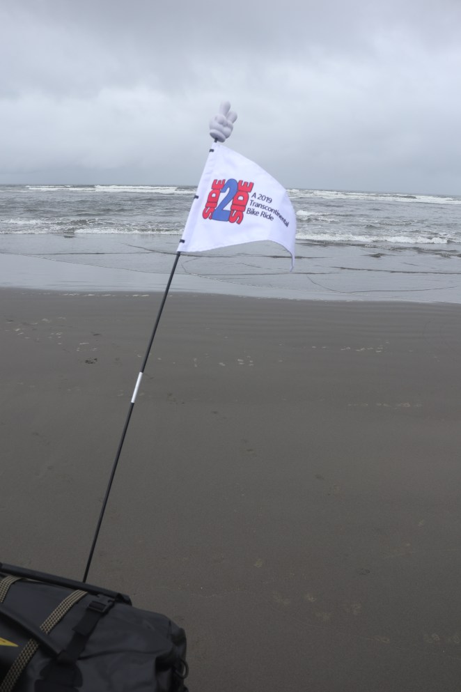
So you also know, from my last substantive post here, that I performed the obligatory wheel dip in the Pacific. And, if you’ve kept up with me on my facebook page, or are a member of one of a number of bicycling groups of which I am a member there, you likely also know that I’m writing this from a campground just outside the agricultural hamlet of Plymouth, Washington, several hundred miles up the Columbia River.

What follows is how, as if i had written this last Saturday, I planned to get from there to here. I’m pleased, as an aside, to be able to say, with the benefit now of 20/20 hindsight, that my planned itinerary has worked quite well. Quite a few folks questioned the wisdom of doing all of the planning I did in the months that led up to Side2Side. I was told everything from, “It’ll have been a waste of time from the first day that things fall apart” to “You’ve sucked all the spontaneity and sense of adventure out of your trip.” Well, we’ll see. There’s close to 14 weeks left for those things to happen, but there’s no sign of either so far. I’ve said it over and over again and I’ll say it here, too. I’m doing this trip the way that works for me. I love having input, tips and suggestions from folks. Sometimes I even do the things that are recommended to me. But, if I don’t, please understand that I’m riding my own ride here. It may not look, sound or seem like the one you’d make if you were wearing my bicycle shoes. But I’m OK with that and I hope that you are, too.

Oh, and for those of you waiting for those promised daily posts with pictures- they’ll (hopefully) all be up later today. So it’s all good. Thanks for hanging in there.

Side2Side Week 1 – June 23 to June 29, 2019
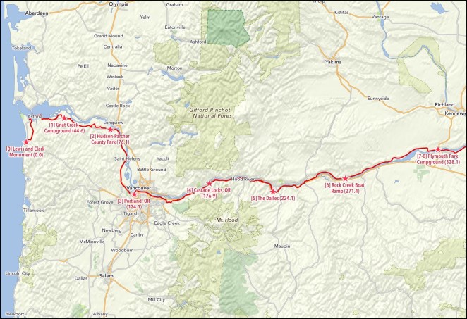
Total miles: 328.1

Road miles: 285.9

Bike path/trail miles: 42.2

Gravel miles (both road and path/trail): 8.1

Riding days: 7

Rest/Slack days: 0

Average distance per riding day: 46.9

Estimated elevation gain in feet: 14,006

Average estimated elevation gain in feet per day: 2,001

Nights camping: 5 (n.b. turned out to be 4)

Nights hosted: 1

Nights hotel/motel: 1 (n.b. turned out to be 2)

Major things to see: Lewis and Clark Monument, Fort Clatsop, Megler-Astoria Bridge, Bradley State Scenic Viewpoint (Clatsop Crest), Portland, Oregon, Columbia River Gorge, Portland Women’s Forum State Scenic Overlook, Vista House, Multnomah Falls, Bonneville Dam, Bridge of the Gods, Mosier Twin Tunnels, Rowena Crest Overlook, The Dalles Dam, John Day Dam

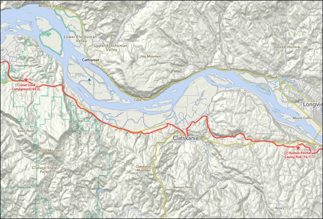
Day 1 – Sunday, June 23, 2019 – Seaside, Oregon to Gnat Creek Campground, Oregon

Cumulative miles: 44.6

Day’s miles: 44.6

Road miles: 37.8

Bike path/trail miles: 6.8

Gravel miles (both road and path/trail): 2.1

Day’s estimated elevation gain in feet: 2,502

Overnight accomodation type: Camping

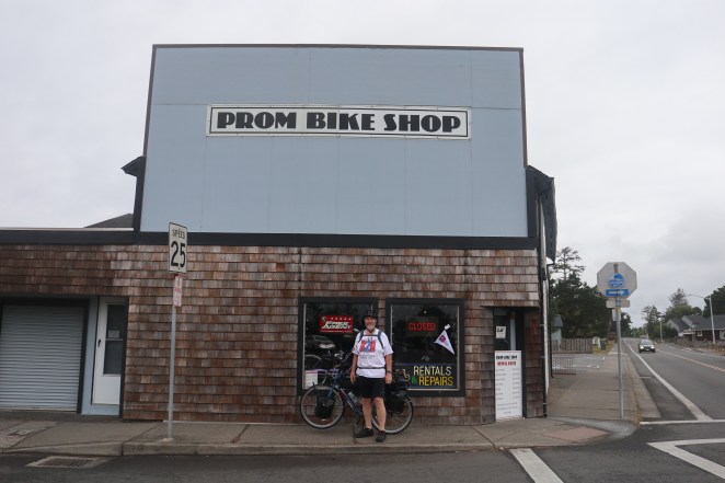
Cities and towns on route: Seaside, OR, Astoria, OR,

Major things to see: Lewis and Clark Monument, Fort Clatsop, Megler-Astoria Bridge

General description of route: Leave Seaside, OR on local roads to east, then head north on private (logging company) “Lewis and Clark Mainline” road, return to local roads near Astoria, OR, stop at Fort Clatsop (Lewis and Clark site), take “Dike Trail” around Astoria Airport, cross Youngs Bay on U.S. Route 101, follow Riverfront Bike Path through Astoria, take U.S Route 30 and parallel local roads east to Gnat Creek Campground, OR

Day 2 – Monday, June 24, 2019 – Gnat Creek Campground, Oregon to Hudson-Parcher County Park, Oregon

Cumulative miles: 76.1

Day’s miles: 31.5

Road miles: 31.5

Bike path/trail miles: 0

Gravel miles (both road and path/trail): 0

Day’s estimated elevation gain in feet: 1,432

Overnight accomodation type: Camping

Cities and towns on route: Westport, OR, Clatskanie, OR,

Major things to see: Bradley State Scenic Viewpoint (Clatsop Crest)

General description of route: Take U.S Route 30 and parallel local roads east from Gnat Creek Campground, OR to Hudson-Parcher County Park, OR

Day 3 – Tuesday, June 25, 2019 – Hudson-Parcher County Park, Oregon to Portland, Oregon

Cumulative miles: 124.1

Day’s miles: 48.0

Road miles: 48.0

Bike path/trail miles: 0

Gravel miles (both road and path/trail): 0

Day’s estimated elevation gain in feet: 1,336

Overnight accomodation type: Host

Cities and towns on route: Prescott, OR, Goble, OR, Deer Island, OR, Columbia City, OR, St. Helens, OR, Scappoose, OR, Burlington, OR, Portland, OR

Major things to see: Portland, OR

General description of route: Take local roads east from Hudson-Parcher County Park, OR to U.S. Route 30. Turn to the south on Route 30 along the Columbia River, then follow it and parallel local roads into the Portland metro area. Take St. Johns Bridge across the Willamette River and the city streets to the host’s residence in Portland.

Day 4 – Wednesday, June 26, 2019 – Portland, Oregon to Marine Park Campground

Cumulative miles: 176.9

Day’s miles: 52.8

Road miles: 52.8

Bike path/trail miles: 18.9

Gravel miles (both road and path/trail): 0

Day’s estimated elevation gain in feet: 1,575

Overnight accomodation type: Camping (n.b. became motel)

Cities and towns on route: Portland, OR, Gresham, OR, Fairview, OR, Troutdale, OR, Springdale, OR, Corbett, OR Cascade Locks, OR

Major things to see: Portland, Oregon, Columbia River Gorge, Portland Women’s Forum State Scenic Overlook, Vista House, Multnomah Falls, Bonneville Dam, Bridge of the Gods

General description of route: Ride north from host’s home on city streets to the Slough bike trail, reaching the Columbia River at Marine Drive. Turn east onto the bike trail that intermittently parallels Marine Drive and take it and Marine Drive past the Portland International Airport through Gresham and Fairview, OR to Troutdale, OR. Continue east on the Columbia River Highway through Troutdale, then start into the Columbia River Gorge area on the Historic Columbia River Highway, following it through Springdale and Corbett, OR and past the Portland Women’s Forum State Scenic Overlook, Vista House and Multnomah Falls. The Historic Columbia River Highway becomes the Historic Columbia River Highway State Trail at the Yeon Trailhead and it is followed east along the Columbia River past Bonneville Dam into Cascade Locks, OR and the overnight at Marine Park Campground

Day 5 – Thursday, June 27, 2019 – Marine Park Campground, Oregon to The Dalles, Oregon

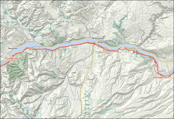
Cumulative miles: 224.1

Day’s miles: 47.2

Road miles: 33.8

Bike path/trail miles: 13.4

Gravel miles (both road and path/trail): 0

Day’s estimated elevation gain in feet: 3,046

Overnight accomodation type: Motel

Cities and towns on route: Cascade Locks, OR, Hood River, OR, Mosier, OR, The Dalles, OR

Major things to see: Mosier Twin Tunnels, Rowena Crest Overlook

General description of route: Leave Cascade Locks following Interstate Highway 84/ U.S Route 30 and parallel local roads east toward Hood River, OR. Follow the Historic Columbia River Highway Trail along the Interstate for a brief stretch. Take local roads into and through Hood River, then resume riding on the trail starting at the Hatfield Trailhead and following it through the Mosier Twin Tunnels. The trail segment ends and the Historic Columbia River Highway is then followed through Mosier and past the Rowena Crest Viewpoint to the outskirts of The Dalles. The Riverfront Trail begins here and is followed to the center of the city.

Day 6 – Friday, June 28, 2019 – The Dalles, Oregon to Rock Creek Boat Landing, Washington

Cumulative miles: 271.4

Day’s miles: 47.3

Road miles: 47.3

Bike path/trail miles: 0

Gravel miles (both road and path/trail): 0.5

Day’s estimated elevation gain in feet: 2,156

Overnight accomodation type: Camping

Cities and towns on route: The Dalles, OR, Biggs Junction, OR, Maryhill, WA

Major things to see: The Dalles Dam, John Day Dam

General description of route: Leave the Dalles, OR on the Riverfront bike path, then follow U.S. Route 30 east to its junction with U.S. Route 197, then follow Routes 30-197 north to a continuation of the Riverfront bike path past John Day Dam, then turn onto Interstate Route 84/Route 30 east, exiting at the Oregon State Highway 206 exit, then follow OR 206 to Biggs Junction, then turn north on U.S. Route 97 and cross the Columbia River into Washington, then turn east after the bridge onto Maryhill Road and take that road east past John Day Dam to Washington State Highway 14, then take WA 14 east along the Columbia River to the Rock Creek Boat Landing.

Day 7 – Saturday, June 29, 2019 – Rock Creek Boat Landing, Washington to Plymouth Park Campground, Washington

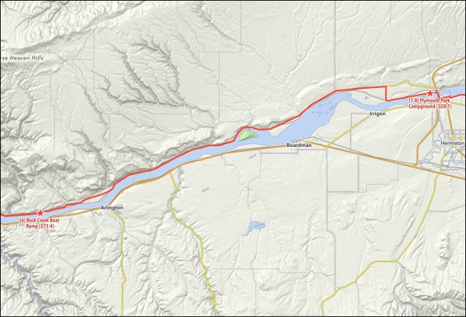
Cumulative miles: 328.1

Day’s miles: 56.7

Road miles: 56.7

Bike path/trail miles: 0

Gravel miles (both road and path/trail): 0.5

Day’s estimated elevation gain in feet: 1,959

Overnight accomodation type: Camping

Cities and towns on route: Paterson, WA, Plymouth, WA

Major things to see: None noted

General description of route: Take Washington State Highway 14 east from Rock Creek Boat Landing to just before entering Plymouth, WA, then local roads to Plymouth Park Campground, WA

Where’s Waldo?

No, I haven’t bagged the blog. Heck, I haven’t even gotten a good start on it yet.

Posts for the first four days are in the pipeline. Plus some bonus content, even! Curating the photos on the road has been the big obstacle, as I’m still sorting out how the “end of the day” timeline works. Sleeping has actually been the priority, just saying…

But I’m at Cascade Locks, Oregon, on track and on schedule, and I’ve got lots to post here.

So we’ll see what happens today.

If it’s Sunday, we must be in… Seaside!

Well

But not just any old part of the Beaver State…

The Side2Side Ride started from here, today, June 23, 2019, at a little after ten in the morning when I finished hanging just about 70 pounds/32 kilograms of panniers, bags, gear and stuff- which I’ll describe for you in a future post- on my 2016 Surly Disc Trucker.

I had stayed last night at the Seaside Lodge International Hostel

which, as far as I was concerned, was just a $33 room in a place where the average cost of a night’s lodging is two hundred dollars and up. Think “the grubbiest place I’ve ever stayed in with four guys I’ve never met before” and head south a bit further- you get the picture. But we didn’t come all this way for dee-luxe accommodations, did we?

Nope. I came to find the Lewis and Clark Monument at the beachside end of Broadway, and I did.

This was as far as the Captains of the Corps of Discovery got on their journey west, and I’ll follow…

well, ride actually…

…more or less in their footsteps all the way back to St. Louis, Missouri, something over 3,500 miles/5,700 kilometers or so from here.

Just in case anyone wouldn’t actually believe I’m here with my bike, I had a kind passing tourist document the event.

So, with those formalities out of the way, I hit the button on Ride with GPS and started Side2Side, heading for the night about 45 miles/75 kilometers up the coast and then inland to Gnat Creek Campground just south of the Columbia River. I started out up the beachside promenade- the “Prom”-

and then headed out to the beach at what I hoped was the closest point to the water to do the obligatory wheel dip. Urrrrrrgh, pushing 110 pounds/50 kg of bike and all the stuff loaded on it across 100 yards/meters of soft sand with the wheels making six inch/15 centimeter deep tracks was harder than riding up a mile long ten percent grade, but I finally made it.

I picked up a shell and a small handful of sand to toss in the Atlantic Ocean 103 days from today and put them away in a small plastic bag. One more thing to carry, but there you go- rituals are important. I rolled the bike across the now seemingly rock-hard sand, stopped, and waited. A small wave came up.

See you on the other side!

Looking East

I am a huge Jackson Browne fan. No kidding, I decided to go to law school after listening to “Lawyers in Love” one too many times. His move to doing mostly overtly political music in the mid-80s wasn’t really my thing, but he had a nice return to form in the 90s with “I’m Alive” and “Looking East.” The title song of that latter album was in my head when I shot this pic.

I was there today, looking east. Some days more than others you feel like you can see a very, very long way. This was one of them.

Ocian in view! Oh, the joy!


I’m in Astoria with about 20 miles/32 kilometers to go to Gnat Creek Campground on the first day of Side2Side. I’m planning to write a “summing up the day” post every evening when I get in, so at worst I’ll be a day behind. But things are going well, with the expected number of minor glitches. The big one- don’t think you can just get your loaded bike out to the water across 100 yards/meters of soft sandy beach in 15 minutes or so.
I don’t know whether there’ll be wi-fi tonight, but we’ll see.

The Side2Side Route, explained

The entire route on Ride with GPS [link].

Starting today, June 23rd, from Seaside, Oregon on the Pacific Ocean I will ride north to Astoria, Oregon then east along the south side of the Columbia River through Portland, Oregon and up the Columbia River Gorge. We’ll cross into Washington state not far past The Dalles, Oregon and ride along the north bank of the Columbia, recrossing the river back into Oregon not far from Umatilla, Oregon.

Continue reading

OK, so what is Side2Side anyway?

The Side2Side Ride I’ll be doing this summer is a 5,000 mile/8,000 kilometer unsupported bike tour across the continental United States- 103 days from Seaside, Oregon to Seaside, New York, a suburb of New York City out on the Rockaways.

Fifteen of those days being what I call “rest/slack” days, which are days I can compress the schedule into if I’m delayed during the previous week or so by weather, mechanical issues and so on. Each of the 88 riding days averages 56 miles/90 kilometers, with the longest day being just over 75 miles/120 kilometers and the shortest just under 30 miles/50 kilometers. I have averaged ten miles/16 km per hour spread over 10,000 or so miles/16,000 km of loaded cycle touring in the past three years, so that isn’t likely to change much this trip. It makes calculating each day fairly easy- I apply ten miles an hour to the planned mileage, add two hours combined for breakfast and lunch, another hour for all the stops to take photos, and then time as appropriate for anything in particular I want to see along the way. I don’t like to ever ride after dusk, so on a really long planned mileage day I’ll adjust the start time earlier as necessary.

Riding across the continental United States- this Side2Side Ride- has been a life goal of mine, and it looks like this is the year. There was never any question in my mind that I would start on the Oregon coast and the route through the Rockies pretty much fell into place from that. An overarching goal of the trip is to ride the length of the Missouri River, from its headwaters near Three Forks, Montana to its mouth on the Mississippi just above St. Louis, Missouri. I’m in the middle of a six year long plan I have made for myself: In 2017 I cycled the length of the Mississippi River from Lake Itasca in Minnesota to Venice, Louisiana down past New Orleans out on the delta in the Gulf of Mexico. Last year as part of a longer trip from Washington, DC to Kansas City, Missouri I rode the length of the Ohio River from Pittsburgh, Pennsylvania to Cairo, Illinois. At the end of this trip I will have thus bicycled down all three of America’s great heartland rivers. At that point I’ll hang my bicycle up long touring-wise and spend the next three years in University of Alaska Anchorage’s Master of Fine Arts in Creative Writing program writing a book about the whole thing, which I hope to see published sometime around my 70th birthday. We’ll see.

…and a flag.

This is the latest in a series of flags flown on the back of my bike during long rides.

Like the license plate [link] it is a conversation starter. No two ways about that. Last year’s flag had just the “DC2KC” logo on it and I was approached several times by people who had no idea what that meant. Tired of explaining, I resolved to be more specific this year. Now I’ll probably get asked in places like Wolf Point, Montana and Elyria, Ohio what continent I’m riding across. But that’s OK, it’s all good.

This is most assuredly, though, not merely a conceit. It is part of my overall safety system, which includes mirrors on both bar ends, a helmet rear view mirror, reflective tape on the back of the helmet, a Garmin “Varia” RTL510 rear-looking radar unit [link] with tail light, a second rack-mounted tail light and high visibility cycling clothing. I want to be able to “see” to the greatest extent what is behind me and I want drivers approaching me from the rear to be able to see me. Other cyclists I ride with and friends who have passed me in their vehicles tell me that the flag is the first thing they notice when I’m ahead on my bike. So that’s a good thing.

It is, though, big ticket bling. I have the flags, which are marine pennant-quality screen printed on both sides on heavy acrylic canvas, made by NorthStar Flag & Flagpole [link] and they cost right around $80 plus shipping. The flag staff is shock corded fiberglass and I bought it, the attachments and the rack mount parts

from the Hostel Shoppe [link], a great recumbent bike shop in Stevens Point, Wisconsin.

I’m headed out to a last breakfast in Portland, and will be on the road to Seaside right after that. The Prom Bike Shop apparently didn’t run into any major glitches putting the Surly back together, otherwise I’m sure I would have heard. See you from there shortly!