 For those of you who have looked at my route on Ride with GPS [linkie] and wondered

let me see if this helps.
I know my route is certainly not the most direct way to get across the country.

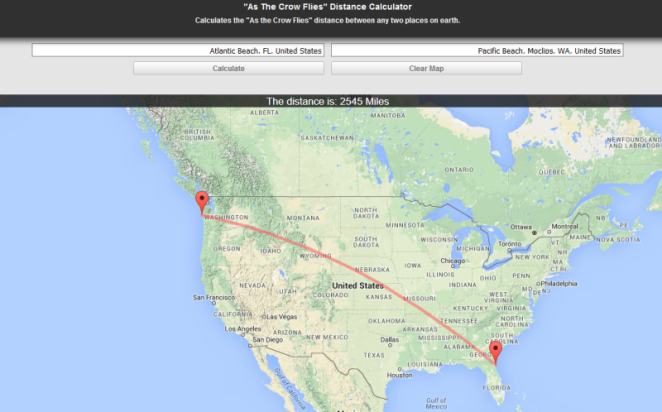
It stays way south for a long time, makes a right-hand turn up the lower Mississippi Valley, then finally starts heading northwest in Arkansas. Relentlessly northwest, almost to the Canadian border. Then I’ll head west again, dipping down into Oregon before the last northwest dash to the Pacific Coast. The distance between the two places is only about 2,500 miles/4,000 km as the crow flies [linkie].
But I’m not a crow. I’m a 63 year old fat guy with, as my grandpa used to say, “arthur-itis.” I haven’t really pushed myself in years. I found out in 2014 when I tried to walk the Cotswold Way in England [linkie] that my knees just won’t let me walk any meaningful distance> But I can cycle all day long at 10 miles/16 km per hour. I mean, does that make any sense?
So I’m setting some goals at the outset. I base my planned mileage (kilometerage?) on riding six of seven days each week. I won’t necessarily need to take advantage of that day, but it’s there if I need it. So the ride goes like this.
- Week one: 40 (and a bit extra) miles/65 km each day for 250 miles/400 km total.
- Week two: 50 miles/80 km each day for 300 miles/480 km total.
- Week three: 66 (and a bit extra) miles/100 km each day for 400 miles/640 km total.
- Week four on: 75 miles/100 km each day for 450 miles/720 km total.
On my Baja and other Pacific Coast rides, I was doing 75 miles/120 km a day by day four. So I think I’ve built in a reasonable cushion, given that those rides were 20 years ago. So I planned my route with, so to speak, an ace in the hole…

The first four weeks of the ride are essentially flat.
Oh yeah, there’s some up and down terrain, especially in week four as the route starts up the valley of the Arkansas River. But not much. And I think I can (or will be able to by that point) deal with it.
David Edgren
