
 Sheesh!
Oh-High-Ah-Pill-Ee?
Oh-High-Oh-Pile?
Don’t even get me started on “Youghiogheny.”
Sheesh!
Don’t even get me started on “Youghiogheny.”
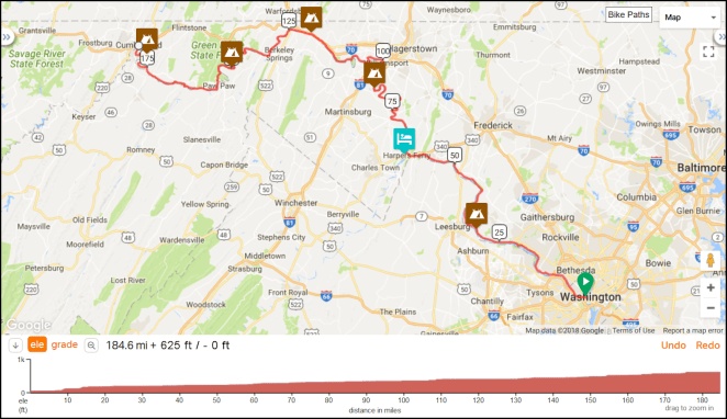
After riding the last four miles or so of the C&O Canal Towpath into Cumberland, Maryland the morning of August 16, 2018, the eighth day of my trip, I will start immediately on the Great Allegheny Passage (GAP) rail-trail to Pittsburgh, Pennsylvania. Here’s what that looks like on a map.

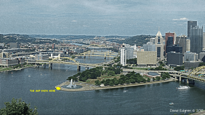
Measured on Ride with GPS the GAP is 150.2 miles/241.7 kilometers from its seamless start at the end of the C&O Canal Towpath in Cumberland to the tip of Triangle Park in front of the fountain at the confluence of the Allegheny and Monongahela Rivers forming the Ohio River in Pittsburgh.
 Base image credit: Public domain
I say measured on Ride with GPS because the Great Allegheny Press’s “Trailguide” [link] says that the GAP is 148 miles/238.2 kilometers long. I’m going to go with the longer figure, as the Trailguide’s number may well be based on the trail ending at a… well, gap that has only recently been completed along downtown Pittsburgh’s Monongahela riverfront.
The GAP and the Towpath’s differing current condition reflects their different origins. Where the Towpath is largely a compacted dirt path that sometimes looks like a one lane road with grass growing in the middle and is made up of level stretches between short inclines at the locks the GAP is a typical rail trail- a repurposed railbed with a rideable gravel surface- often “crusher run”- with an up and down elevation profile.
Looks like up and down. right?
Well, just like you can lie with statistics, you can also do that with elevation profiles. That horrific looking shark-fin of a climb between Cumberland and the Eastern Continental Divide is, in actuality, a gentle, steady just slightly less than two percent grade all the way up. That’s because the Western Maryland Railroad, the tracks of which became the GAP in this area, had a controlling grade- in other words the maximum allowed- on this line of two percent. The reason it looks so daunting on the elevation profile is bcause the “distance” axis is 150 miles/250 kilometers long while the elevation axis is only 2,000 feet/600 meters- four-tenths of a mile/two thirds of a km- tall. The profile thus exaggerates the vertical axis by a factor of about 125 times.
But just because the upgrade is two percent doesn’t mean that cycling this part of the GAP is the same as riding on a nice flat parking lot. That’s a rise of two feet/60 centimeters for every 100 feet/300 meters that you ride. How hard in general is that? I’ve long used in discussions of grade and bicycling a chart put out there by the Bike Hudson Valley club on its website [link], as it strikes me as describing pretty much the way hills affect me.
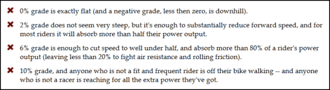
So another way of look at what is said here is that, over the 22 miles/35.4 kilometers of the 1,800 foot/550 meter or so climb between Cumberland at about 600 feet/180 meters above sea level and the summit- the Eastern Continental Divide- at about 2,400 feet/730 meters in elevation, the effort required will be equivalent to a 44 mile/71 kilometer ride on the flat. That’s not insignificant, and when you take into account that the climb is both relentless- there’s no breaks- and is on an unpaved albeit decent surface, well… you get the picture. There’s always the roughly 75 mile/120 kilometer downhill after you reach the divide to look forward to.
As was the case with my discussion of the history of the C&O Canal and Towpath in a previous post, I’ll touch on a few high points and leave it at that, as there is a fairly comprehensive presentation of this information in the TrailGuide. The Baltimore & Ohio (B&O) Railroad was the first to build trackage through the Cumberland-Pittsburgh corridor, completing it in 1871. About ten years later the Pittsburgh & Lake Erie (P&LE) Railroad built a spur paralleling the B&O from Pittsburgh to Connellsville to carry coal and coke to steel mills from large deposits found along the Youghiogheny River, which flows through the area. In the early 20th century the Western Maryland Railroad laid tracks over the crest of the Appalachians between Cumberland and Connellsville, connecting to the P&LE there. By 1975, though, there was not enough freight traffic to sustain both the B&O, which would a decade later become CSX, and the Western Maryland/P&LE line, in that the tracks of each were along most of the route just a few yards/meters from the other. The Western Maryland began abandoning sections of trackage first. The P&LE followed in the the 1980s following the closure of the last large coal mine in the area. By 1991 all of the Western Maryland and P&LE lines had been abandoned.
The creation of the rail-trail that ultimately grew into the GAP began on the late 1970s with the private purchase of 27 miles/43.5 kilometers of abandoned Western Maryland right-of-way followed by ts subsequent donation to the state of Pennsylvania. Construction of the rail-trail began in the state’s Ohiopyle State Park and, by 1986 the first nine mile/14.5 kilometer stretch opened between the park and the north side of Confluence, Pennsylvania. Groups urging construction of more trail mileage were formed along the length of the abandoned lines and began purchasing additional parcels of the right-of-way. In 1995 all the groups merged into the Allegheny Trail Alliance. There was steady progress on assembling the land needed and then building the trail. The Trailguide states that over eighty million dollars has been raised and spent to bring the GAP, less a short section along the Monongahela River waterfront in Pittsburgh, to completion, which was officially declared in 2013. This date marks the opening of a now continuous off-road cycling route from downtown Washington, D.C. to downtown Pittsburgh via the C&O Canal Towpath and the GAP. I’ll note that the state of Pennsylvania and City of Pittsburgh stepped in to build that last piece: the Mon Wharf Ramp, which maintains the GAP off-road around the spaghetti tangle of freeway ramps along the Monongahela just south of the city center. It opens this year. The year 2018 also marks the 40th anniversary of the first acquisition of land for construction of the GAP
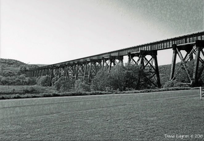
I’ll spend more time describing the various tunnels and high viaducts that are found along the GAP when I complete the daily itinerary that will be posted on this blog shortly.
 Base image credit: Public domain
Suffice it to say for now that there are incredible things to be seen along the length of the GAP in addition to the tremendous physical beauty of the area through which it passes.
The surface of the Towpath, as noted, is generally small gravel or crusher run, solidly compacted. There are a few asphalt sections, particularly as the trail nears Pittsburgh. Nothing I have read gives me any concern that the GAP will present any particular challenge to my loaded touring bike.
As is the case with the C&O Towpath, there are fairly evenly spaced opportunities for the bikepacking cyclist to camp along the Towpath. Along with several commercial campgrounds there are a couple of no-cost “Hiker/Biker” primitive campsites. Once again these latter sites are first come-first served but the etiquette of cyclists making room for a later arrival reportedly holds true. I plan to stay at a municipal campground, an Army Corps of Engineers campground and two Hiker/Biker sites as I ride my five days along the GAP, plus with a WarmShowers host in the Pittsburgh area.
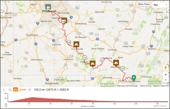
If you draw a straight line between Cumberland and Pittsburgh it heads in an almost perfect northwest direction. This distance crossed by the line is 85 miles/136.8 kilometers, so you can see that, at almost twice as long between the two cities, the Gap winds around a bit. In Cumberland I will still be on the east side of the Appalachian Mountains. The Gap leaves the North Fork of the Potomac River almost immediately then climbs along small streams to the Eastern Continental Divide 23.5 miles/37.8 kilometers past Cumberland. Coming down the other side the GAP follows Flaherty Creek to Meyersdale, Pennsylvania, then runs along the banks of the Casselman River for just over 30 miles/50 kilometers to Confluence, Pennsylvania, then along the Youghiogheny for about 40 miles/65 kilometers to McKeesport, Pennsylvania, then finally along the Monongahela River for 15 miles/25 kilometers to its confluence with the Allegheny River just past downtown Pittsburgh. The Appalachian Mountains are left behind at Connellsville, Pennsylvania at the 90 mile/145 kilometer point, although the terrain around the river valleys is anything but flat along the remaining distance.
A great online resource to accompany the TrailGuide is the Great Allegheny Passage website [link]. Finally, here’s an area map of Pennsylvania and surrounding states with the route of the Gap highlighted in blue.
 © 2018 RandMcNally, fair use asserted
Next up: My itinerary for the first segment of the ride down the Ohio River- from Pittsburgh to Cincinnati, along with some pre-ride comments.
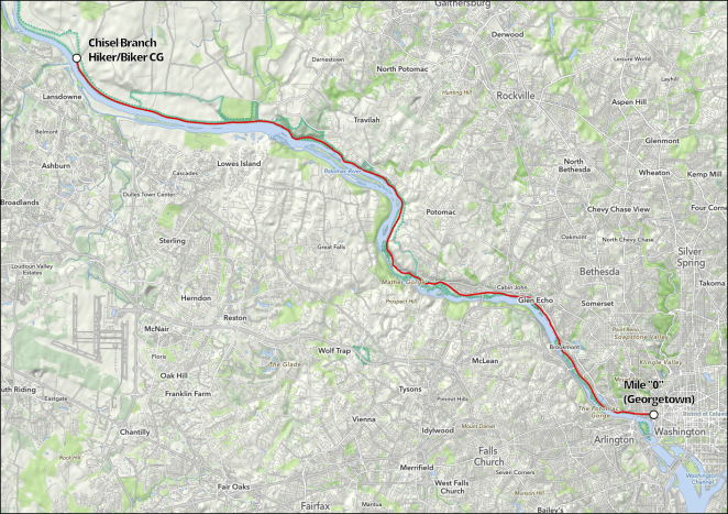
As I’ve previously noted I’ll spend six riding days and the smidgen of a seventh on the C&O Canal Towpath from its east to its west end at Cumberland, Maryland. Here’s the entire towpath

and here’s each day’s ride:
Day 1 – Thursday, August 9, 2018
Washington, D.C. (Mile 0) to Chisel Branch Hiker/Biker Campground (Mile 30.5)
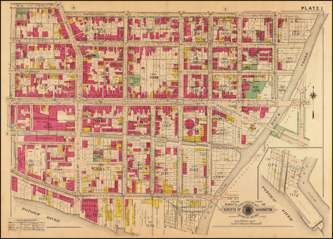
The Canal and Towpath begin in the Georgetown area of D.C. Several sources I have looked at say that finding the actual start of the Canal is a bit “tricky,” but I’ve found the the Great Allegheny Press’s “Trailguide” [link] to be a great resource in that regard. On page 96 of the 14th Edition it notes:
From the C&O Visitor Center near Lock 3, walk or bike on the brick sidewalk with the canal on your right. After 29th Street the brick path ends at Rock Creek Parkway Trail. Turn right onto the asphalt sidewalk. Cross the entrance ramp of the Whitehurst Freeway; pass underneath K Street; then cross the exit ramp. At the Thompson Boat Center sign, turn right into the parking lot. Cross Rock Creek Bridge. Bear left around the Boat Center and pass between the boat house and river. Pass around a stockade fence. Cross over the inlet lock footbridge to reach the granite monument marking Mile 0.
Sheesh! I’ll have to pack a lunch just to get to the start of the ride!
The Trailguide also provides a map, which would appear to me to make everything pretty straightforward.

© 2018 Great Allegheny Press, fair use asserted
I want to make sure everyone understands that there’s no intent to leech off all the hard work that the Great Allegheny Press folks have put into the Trailguide. In fact, if you plan to ride the Towpath or GAP, you really need to buy a copy buy a copy [link]. In addition to providing really useful information like the above, the purchase of the Trailguide as the proceeds are reinvested in the Towpath and GAP trail.
Projects like helping with rockslides at Paw Paw Tunnel and near Sutersville, PA, signage, rehabbing the Pinkerton Tunnel to eliminate a detour, help with resurfacing the towpath near Hancock, a few bike repair stations, and a blueprint for improving the towpath were funded with proceeds from this publication.
Trailguide, 14th Edition, p. 9
Back to Georgetown.
I have two days to ride around Washington, D.C. and Northern Virginia- the 7th and the 8th– before I start the ride. One thing I plan to do is ride the Towpath in Georgetown so that I can take the several hundred photos that I know I will want to take of this incredibly historic and scenic area. Bonus: I’ll scout out the start of the Towpath so I can get an immediate start on the 9th.
Once out of Georgetown I’ll pass a number of “must see” scenic and historic sites. These include
I’ll say a few words here about the Bike Washington C&O Canal Towpath web pages [link]. While the Trailguide provides an excellent overview of the Towpath’s route, the Bike Washington site is where you should then go for detail. It provides mile by mile info in a handy form [link].

For iPhone users like myself a lot of Bike Washington’s info is available on an app [link], so it can be easily accessible on a ride. A huge amount of work has gone into putting all this together and kudos are well deserved by all involved.
This first day on the Towpath includes a C&O Canal and Towpath major scenic highlight: the Great Falls of the Potomac. Starting at around Towpath Mile 12, the Great Falls area presents incredible natural beauty and a stunning illustration of the sort of challenges and obstacles the builders of the C&O Canal faced almost 200 years ago. The National Park Service has created a nice detail map of the Towpath from Mile 0 to the Great Falls area.
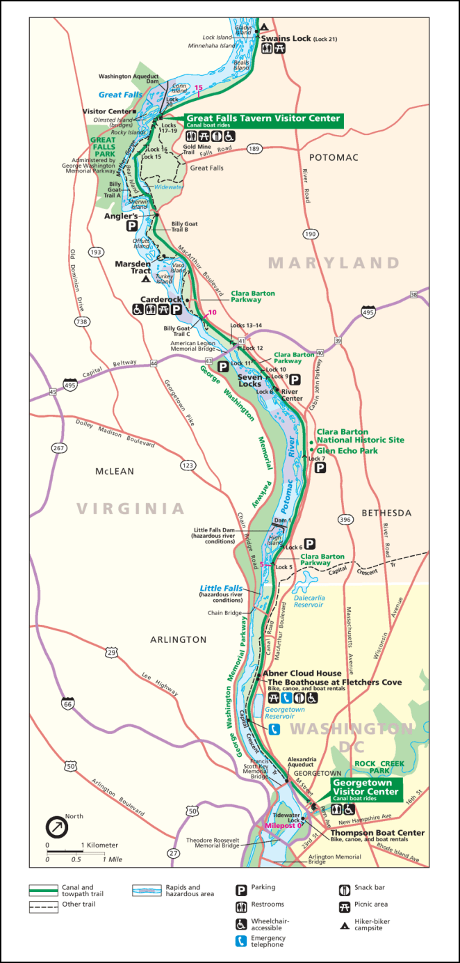
It is a shame maps at this level of detail aren’t available for the entire Towpath. The NPS also has a very detailed map of the Great Falls area itself. While the map is mainly for the benefit of hikers, it gives an excellent sense of the things that there are to stop and see in this amazing place.
I was briefly confused by the use of the term “aqueducts” in connection with the Canal and Towpath. I had a concept of an aqueduct as a channel, often depicted up on a bridge, to carry water into an urban area or an agricultural zone.
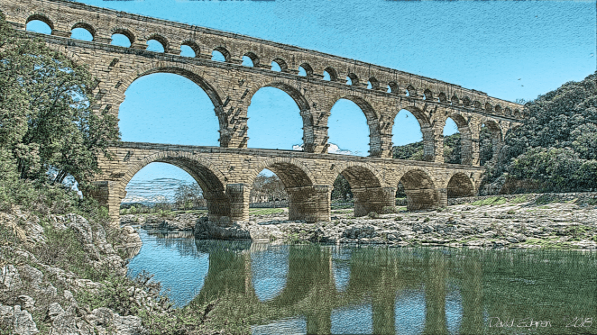
There are eleven aqueducts along the route of the C&O Canal and Towpath. I’ll see the first of these today at Mile 22.8 across Seneca Creek. These aqueducts carry the Canal and Towpath over the various small streams that flow into the Potomac. They are beautiful works of early 19th century civil engineering and the Park Service has done an incredible job restoring and preserving them.
I am assuming that today’s ride will take all day long due to the numerous stops I will be making to take photos and just to see the sights. Once outside of Georgetown there are no cities or towns that I will pass through before arriving at Chisel Branch Hiker/Biker Campground. I will plan to grab lunch at the Great Falls Snack Bar about halfway through the ride and will carry a cold supper in my panniers.
Day 2 – Friday, August 10, 2018
Chisel Branch Hiker/Biker Campground (Mile 30.5) to Teahorse Hostel (Mile 60.4 + 1.3 miles off route)
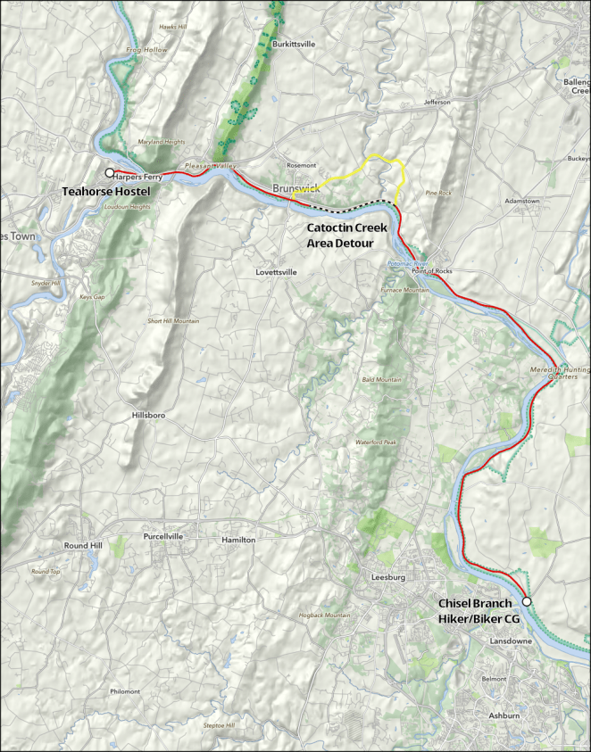
On the second day of my ride up the Towpath I’ll pedal 31.4 miles/50.5 kilometers from the Chisel Branch Hiker/Biker Campground to the historic city of Harpers Ferry, West Virginia. During the day I’ll pass through a gap in the first outlier ridge of the Appalachian Mountains at the community of Point of Rocks, Virginia, deal with a detour around a section of the Towpath that is closed due to a culvert washing out, and enter West Virgina, a state of which I’ll see much more, in a couple of weeks, for the first time on the ride. I may also decide to do a “there and back” crossing of the Potomac on White’s Ferry, which operates at a location from which there has been continuous ferry service since 1817.
It looks like I’ll have to deal with a detour around a place on the towpath where a culvert has washed out and not yet been repaired near the Catoctin Creek Aqueduct.
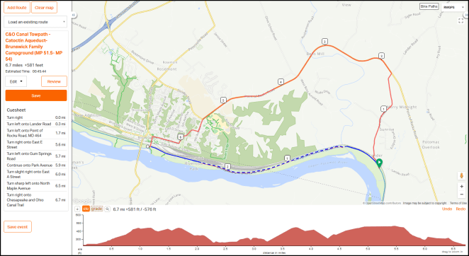
There’s about 6.7 miles of local roads to navigate in making the detour. Reportedly they are hilly and narrow, and the Park Service tries to discourage riding on them and recommends arranging a shuttle through the area instead.
There is no detour in place at this time due to unsafe conditions on adjacent roadways.
Well, clearly there is a detour. And it’s a free country and those are public roads. I have a hard time imagining that they present a worse challenge than, say, the miles of mountainous narrow high traffic highways I tour on up here in Alaska. A shuttle may be fine for some, but I think I’ll take a pass on it and brave the “no detour” detour.
Or, maybe not. A friend who will remain anonymous has let me know that he rode up to the washed out culvert, unpacked his bike, carried it across the ankle-deep stream, went back and made a second trip with his panniers, reloaded the bike and was on his way. Sounds like a plan to me. We’ll see.
It looks like Point of Rocks will be a nice place to stop for lunch. I can get dinner in either Brunswick or after I arrive in Harpers Ferry. Probably I’ll just stop at a store and get hard sausage and a piece of cheese. Hey! I like sausage and cheese, the perfect cycling dinner.

Day 3 – Saturday, August 11, 2018
Harpers Ferry (Rest/Slack Day)
Harpers Ferry!
Well, that is what comes to my mind, anyway.
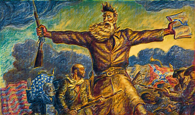
John Brown’s 1859 raid on the Harpers Ferry arsenal is just a small piece of the history of this gem-like little town, now largely historically preserved by the National Park Service. It is a major Civil War location as well. Here’s a map of Harpers Ferry and the surrounding area that will give you an idea of the size of the Park Service’s holdings in the area.
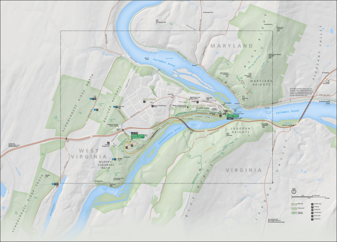
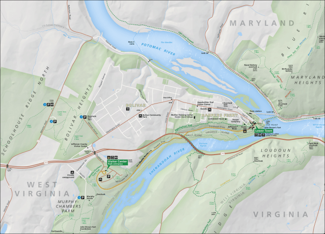
Due to the large size of that map I have outlined the central area of Harpers Ferry appearing in the map below with a gray dashed line.
Here’s a National Park Service isometric map of the historic area downtown and immediate environs.
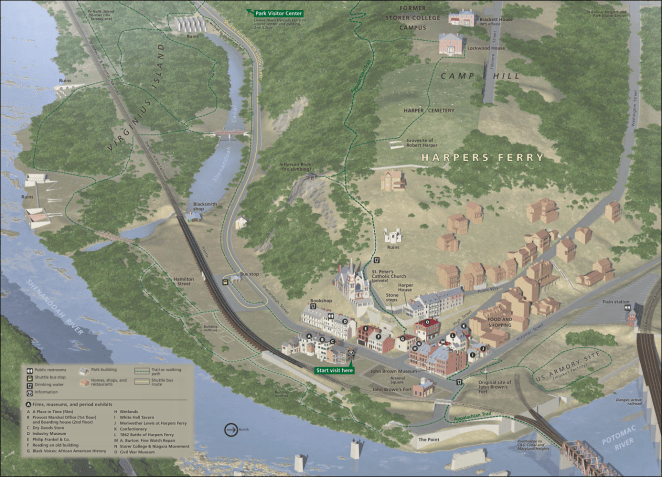
Harpers Ferry is located at the confluence of the Shenandoah and Potomac Rivers.
It is here that Virginia gives way to its poor relation sibling West Virginia; a result of the division between slave and free factions during the Civil War. Beyond its historic significance, the city is a major milestone along the 2,178 mile/3,505.2 kilometer Appalachian Trail in being located on the trail’s approximate midpoint and in being the home of the Appalachian Trail Conservancy and its Visitor Center.
I’m taking my first rest/slack day of the trip here not so much because I think I’ll need on, but because I have just always wanted to see the place. A day will give me enough time to walk around the historic district, visit the ATC Visitor Center (I’m a frustrated wannabe through-hiker) and just hang out in general. I have reservations for two nights at the Teahorse Hostel, which reportedly serves a nice breakfast. I’ll have secure storage for my bike and gear there, so I won’t be worried about being away from it for a while while I look around. I’m sure many photos will be taken.
Day 4 – Sunday, August 12, 2018
Teahorse Hostel (Mile 60.4 + 1.3 miles off route) to Opequon Junction Hiker/Biker Campground (Mile 92.7)

Presumably refreshed by a nice breakfast on the way out of Teahorse Hostel, I’ll leave Harpers Ferry and West Virginia on the bike/footbridge across the Potomac, then get back on the Towpath and ride 32.3 miles/52 kilometers mainly in a north-northwesterly direction to Opequon Junction Hiker/Biker Campground. The highlight of today’s ride is the Antietam Battlefield- the site of the bloodiest day of the Civil War.
I probably will not stop in Shepherdstown, but will instead enjoy the view into it across the river. This is because I will add about 10 road miles/16 kilometers to the day by riding off the Towpath into Sharpsburg and visiting the Antietam Battlefield.
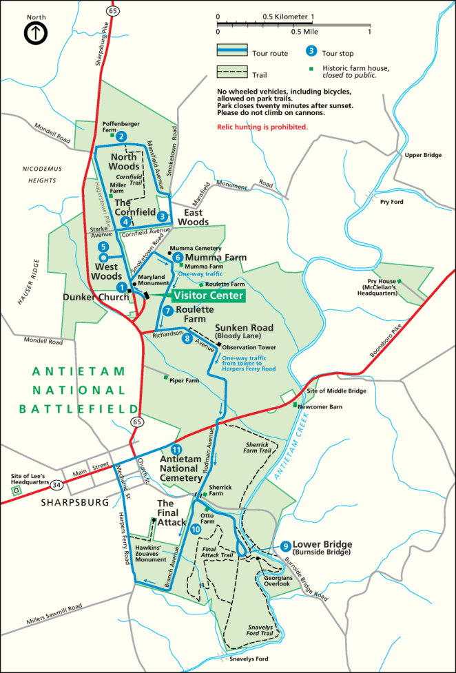
I’ll cycle around the battlefield roads and reflect on the sad chapter in our history that led to the preservation of this otherwise lovely place. After leaving the battlefield I’ll stop in Sharpsburg for lunch and to pick up a cold supper to eat at the campground.
Day 5 – Monday, August 13, 2018
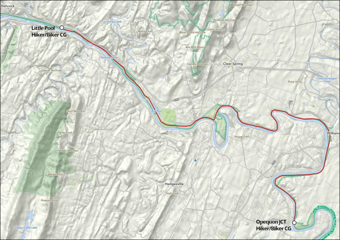
Opequon Junction Hiker/Biker Campground (Mile 92.7) to Little Pool Hiker/Biker Campground (Mile 122.2)
My first McDonald’s breakfast of the trip will likely happen today.

The restaurant is about a mile off route in Williamsport, Maryland. I should have a nice appetite worked up by the time I get there. I’ll look around the city, check out the Visitor Center, pick up a cold supper and other supplies at a grocery, and head back to the Towpath. The remainder of the day does not have any “big ticket” things to see. Rather, it’s just a nice ride through an area that, as I ride further into the western part of the state of Maryland, is becoming more mountainous, remote and thinly settled. There are no places to eat or stores along the Towpath for the rest of the day past Williamsport.
The ride is fairly short today: 29.5 miles/just slightly less than 50 kilometers. I am undecided as to whether I will stay on the Towpath or take the paved Western Maryland RR Rail-Trail that runs parallel to it just a few tens of yards/meters away. I guess it will depend on the condition that the Towpath surface has been in. We’ll see.
Day 6 – Tuesday, August 14, 2018
Little Pool Hiker/Biker Campground (Mile 122.2) to Stickpile Hill Hiker/Biker Campground (Mile 151.2)
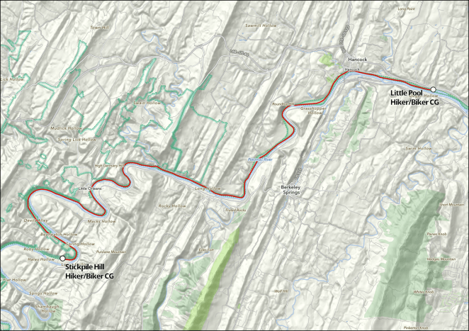
The sixth day of my ride is another just under 30 mile/50 kilometer day. Almost immediately after I start in the morning I will ride through Hancock, Maryland. There’s no McDonald’s here, but I should be able to find a nice local café. Once again I’ll stop to pick up cold food for supper, as there is nowhere else along the Towpath to stop for the rest of the day except for a bar: Bill’s Place, near the hamlet of Little Orleans.
The Canal and Towpath have entered the central Appalachians today.
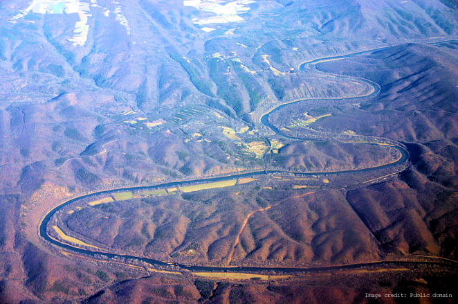
Potomac River bends around New Orleans, which is in the center of the image
The land is incredibly rugged on both sides of the Potomac, and the ability of the river to carve the narrow gap I will ride in is almost incomprehensible.
Day 7 – Wednesday, August 15, 2018
Stickpile Hill Hiker/Biker Campground (Mile 151.2) to Evitts Creek Hiker/Biker Campground (Mile 180.0)

The final day of my ride on the Towpath will have its challenges. Well, one challenge, actually, but it is a big one.

Paw Paw Tunnel, downstream portal
The Paw Paw Tunnel is expected to be closed, per the Park Service, starting August 1st [link] in order to allow continued stabilization of the cliffs that the Towpath runs next to as it approaches the downstream portal. As I will miss that date by about two weeks, this will require that I make a strenuous “over the mountain” detour, of which I will say more below.
The day’s cycling is the shortest of the full days on the Towpath at just under 29 miles. I’ll get lunch in Paw Paw, West Virginia at the convenience story there. Just after I pass the Forks of the Potomac- the Canal and Towpath follow the North Fork- I’ll make another foray into West Virginia, this time into the hamlet of Green Spring and will, as has become the custom, pick up some items for a cold supper. From there it will be a couple more hours to the outskirts of Cumberland, Maryland and Evitt’s Creek Hiker/Biker Campground.
The Paw Paw Tunnel detour is a big deal. Beyond missing the experience of cycling through this masterwork of 19th century civil engineering, I will have to walk my loaded bike up a dirt path that climbs an almost 400 or so foot/120 meter ridge which at some points exceeds a 15% grade and then walk it down the other comparably steep side.
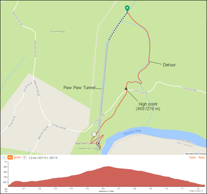
I’m figuring that this one and a quarter mile long death march will easily take a couple of hours. I am not looking forward to it.
So on Wednesday, August 16th, I’ll get up, pack my gear on my bike, and ride the last four miles/six and a half kilometers of the Towpath. When I reach the middle of the city of Cumberland and the end of the C&O Canal, the Towpath will become the Great Allegheny Passage- the GAP, and I will be more than halfway from the start of my trip in Washington, D.C. to Pittsburgh, Pennsylvania. That segment of my ride will be coming up next- thanks for following along.
As I work on the C&O Canal Towpath Itinerary post a couple of things came to mind.
 Two weeks? Urrrrgh! Anyway, in the meantime here is a [link] to the Natchez Trace Ride journal. And, while I’m at it, you can also visit if you are interested the journal of the Big Alaska Road Loop Ride [link] and last fall’s ride down the length of the Mississippi River from Lake Itasca, Minnesota to Venice, Louisiana on the delta out in the Gulf of Mexico [link] as well.
So thanks for bearing with me as I get things going here again. I plan to do my absolute best to update the blog on a more or less contemporaneous basis during this fall’s trip. Thanks for coming along for the ride.
David
I will spend the first seven days of my 53 day long ride on the C&O Canal Towpath, plus a tiny fraction of day 8 as I ride from the last Hiker/Biker campground into Cumberland, Maryland to start onto the Great Allegheny Passage (GAP) rail-trail to Pittburgh, Pennsylvania. Here’s what that looks like on a map.
As I have noted previously, the Towpath is 184.5 miles/296.9 miles long. That breaks down nicely into six just about 30 mile/50 kilometer riding days. Once again as noted there are nicely spaced camping and other lodging opportunities along the entire towpath, so it is easy to stay within a few miles/kilometers of that figure every day.
I’ve been asked by several folks, “Why 30 miles/50 km?” I have an easy answer for that.
And what does that mean? Well, that’s how old I’ll turn about two-thirds of the way into the ride. If you live in southern Illinois and want to come celebrate my 66th birthday with me, feel free, but bring your own cake. Back to the point- my last experience cycling any appreciable mileage with a loaded bike on any sort of unpaved surface was… hmmm… well, never, actually. I had a few stretches on my Atlantic Coast ride two years ago and one hellish “road closed” ride on a levee in bright sun and 90 degree (F)/33 degree (C) heat for about 25 miles/40 kilometers last fall in the state of Mississippi riding down the river of the same name, but for 300 miles/500 kilometers at a stretch?
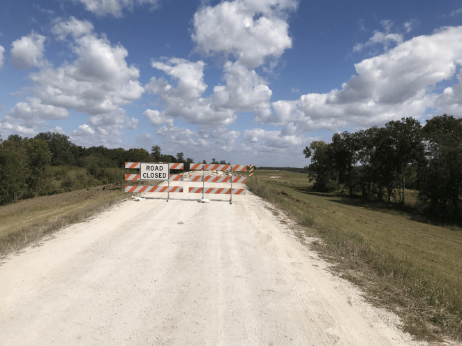
“We don’ need no stinkin’ “road closed” signs”
I hate washboarded gravel that makes your panniers feel like they are about ready to tear loose. I detest those big occasional rocks that sneak under the tires every so often regardless of how hard you watch for them and leave you feeling like your front rim is about to taco. I despise those little rocks that get shot out from under the side of the tires with a “Pu-twang!!” noise that has you knowing you are just about to have a catastrophic flat. But most of all I just hate being too old to enjoy the little frisson from engaging in risky behavior that goes with these things. In short, pavement has always been my friend.
So, after a huge leap of faith based on reports from friends that neither the Towpath nor the GAP was that bad, I decided to give the two of them, and the KATY and Rock Island rail-trails later on in the trip, a shot. Out of an abundance of caution, though, I used 30 miles/50 kilometers a day as my planning factor as opposed to the usual 50 miles/80 kilometers for any day I was riding off pavement just in case. This added about seven days to the length of my ride. Will that have been necessary? I guess we’re about to find out.
David
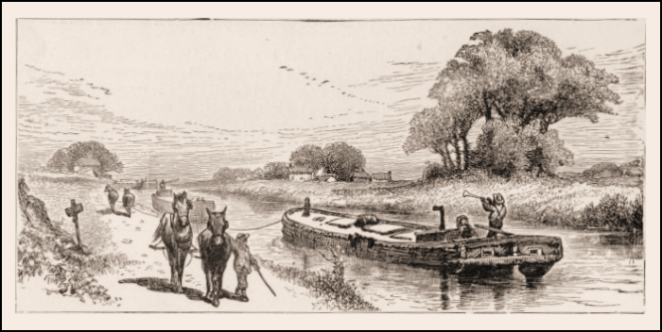
My trip from Washington, D.C. to Kansas City will start on the 184.5 mile/296.9 kilometer long C&O (Chesapeake & Ohio) Canal Towpath which runs along the abandoned C&O Canal on the north side of the Potomac River between the Georgetown District of D.C. and Cumberland. Maryland. The Towpath’s purpose when built is evident in its name- a path to allow the people and animals to pull with ropes the laden canal boats upstream against the modest current. It was probably pretty slow going.
Briefly, as there are comprehensive sources about the C&O Canal and its towpath readily available on the web- a good place to start is the National Park Service site [link]– the canal was envisioned by, among others, George Washington in the late 1700s, as a way to commercially link the Middle Atlantic states and the Ohio Valley. Construction started on July 4, 1828 and the Canal was completed to the city of Cumberland 22 years later, never reaching the Ohio Valley. The reason for this is found in another ambitious transportation start-up that, in a twist stranger than fiction, broke ground the same day in 1828, the Baltimore & Ohio Railroad. By the time the Canal reached Cumberland the railroad was already there and in fact would reach the Ohio River at Wheeling, West Virginia two years later in 1852. The Canal was, essentially obsolete from that point on and plans to extend it further westward were abandoned. Amazingly it continued to operate until 1924, when it ceased operations altogether and maintenance was discontinued.
Ownership passed to the federal government in the Great Depression. For a long time nobody seemed to know what to do with the Towpath. There was a proposal to build a scenic parkway along its course, which would have been lovely but thank heavens nothing ever came of it. In the mid 1950s Supreme Court Justice William O. Douglas made a eight day hike on the Towpath in support of his argument that the Canal should be restored and preserved as a historical monument. In 1971 President Richard Nixon signed an act doing just that, entrusting the work and management to the National Park Service. Coming up on 50 years later and just a decade short of its 200th anniversary, the C&O Canal Towpath has been largely restored to the condition it was in during its prime.

Over the past 25 years the C&O Canal Towpath has become one of bicycle touring’s Holy Grails. While I could not immediately find statistics for through rides, anecdotally it would appear that several thousand riders do this one way or the other every year. Some even make it a round-trip!
The surface of the Towpath is mostly dirt and small gravel. Sometimes it looks like a one lane road with grass growing down the middle. Sometimes there are roots and larger stones to watch out for. In rainy periods it can become very muddy. It is my understanding that, while the Towpath surface is more challenging than riding on a conventional unpaved bike trail, it is reasonably rideable on a loaded touring bike so long as wider tires, such as my 700x38s, are used. We’ll see.
As noted, the official length of the Towpath is 184.5 miles/296.9 kilometers from end to end. In Cumberland it directly transitions into the Great Allegheny Passgae (GAP) Trail, which allows for a continuous off-road cycling route from D.C. to Pittsburgh, Pennsylvania. This is the route I will be following on this stretch of my ride. The Towpath climbs, depending on whose figure you go by, somewhere between 605 feet/184.4 meters and 625 feet/190.5 meters between D.C. and Cumberland, and there is no appreciable elevation loss along its length. For east to west cyclists the climbing is done every time a lock and dam on the canal is passed, which results in more than 70 short 8-10 foot/around three meter rises by the time the ride is complete. Between these short climbs the towpath is more or less, as one would expect, flat.
There are numerous opportunities for the bikepacking cyclist to camp along the Towpath. Along with several commercial or non-NPS public campgrounds there are frequent “Hiker/Biker” primitive campsites, which are free of charge- an amazing throwback to better times. These sites are first come-first served but my understanding is that no cyclist ever gets turned away from a Hiker/Biker location, as the people already there observe the etiquette of making room for a later arrival. I plan to stay at four Hiker/Biker sites, one other campground and a hostel- The Teahorse- in Harpers Ferry, West Virginia on my ride.
The area traversed by the C&O Canal Towpath on an east to west ride is first the foothills and then through the Appalachian Mountains proper. The Eastern Continental Divide is reached on the GAP 23.5 miles/37.8 kilometers past Cumberland. The Potomac River flows through this area in a steep-sided valley that often has just enough room on its floor for the river, the Canal and Towpath, and one or more ever-present still in use rail lines. The mountain ridges generally cross at a more or less perpendicular angle to the valley.
A couple of other great resources are the BikeWashington C&O Canal Towpath website [link] and the Great Allegheny Press’s “Trailguide” [link], which is now in its 14th edition and covers both the Towpath and the GAP Trail. Finally, for those of you who like to visualize using road maps, here’s an area map of Maryland and surrounding states with the route of the C&O Canal Towpath highlighted in blue.
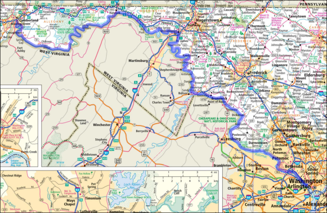
© 2018 RandMcNally, fair use asserted
Next up: My C&O Canal Towpath itinerary and some pre-ride observations.
For the last couple of long rides I’ve done I have had cards made up so that I don’t need to write things down over and over for people I run into along the way. I have made several friends from the 100 cards or so I passed out along the Natchez Trace this spring and another 100 I gave to folks along the route of my Mississippi River ride last fall. Cheap to do- I designed my own artwork and have the cards made by Vistaprint, which always seems to be running a sale that brings the cost down to less than ten bucks plus shipping.

OK, so with the Alaska Big Road Loop Ride pretty much wrapped up I have just under four weeks to get ready for my fall ride: Washington, DC to Kansas City, MO via the C&O Canal Towpath, Great Allegheny Passage (GAP) Trail, Pittsburgh, PA, the length of the Ohio River to Cairo, IL, then up to St. Louis, MO and across that state on the KATY and Rock Island rail trails to KC.
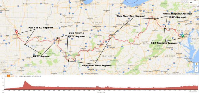
Washington DC to Kansas City MO
Distance: 1,932.4 miles/3,110.0 km
Total elevation gain: 43,345 feet/13,211.6 meters
Ride with GPS link
I’ll leave Alaska on August 5th and finish up in Kansas City on September 30th. Eighty percent of the overnights will be camping with the rest made up of Warmshowers, family and friends and a couple of motel nights. The trip will be unsupported. I will not be bringing anything to cook or dine with (other than a Swiss Army knife and a spoon- ice cream!) so will eat at restaurants/cafes or from grocery stores along the way. I will be riding on average 30 miles/50 kilometers a day on the C&O Towpath, GAP, KATY and Rock Island RR trails and 50 miles/80 km per day on the rest. I’ll take one day a week as a rest/slack day.
Here are the segments.
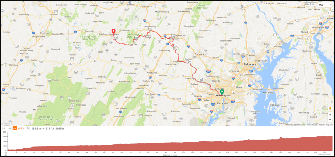
C&O Canal Towpath Segment
Distance: 184.6 miles/297.1 km
Total elevation gain: 1,611 feet/491 meters
Ride with GPS link
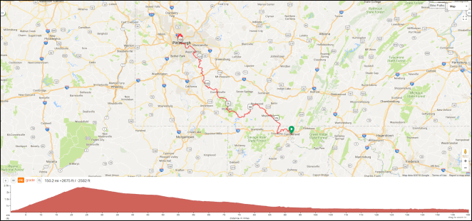 Great Allegheny Passage (GAP) Segment
Distance: 150.2 miles/241.7 km
Total elevation gain: 2,675 feet/815 meters
Ride with GPS link
 Ohio River Segment East (Pittsburgh, PA to Cincinnati, OH)
Distance: 483.1 miles/777.5 km
Total elevation gain: 9,659 feet/2,944 meters
Ride with GPS link
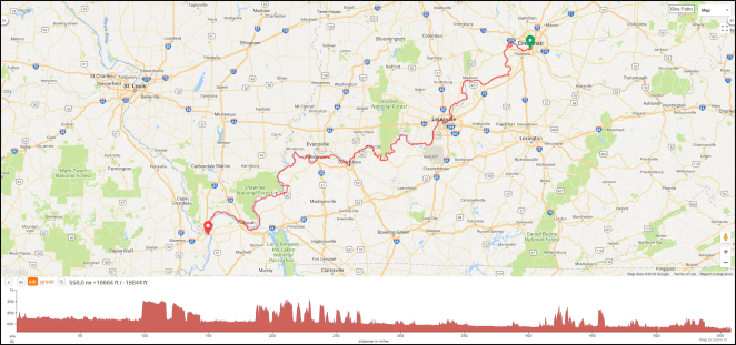 Ohio River Segment West (Cincinnati, OH to Cairo, IL)
Distance: 558.0 miles/898.0 km
Total elevation gain: 16,664 feet/5,079 meters
Ride with GPS link
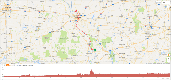 Ohio River to KATY Segment
Distance: 215.0 miles/346.0 km
Total elevation gain: 3,678 feet/1,121 meters
Ride with GPS link
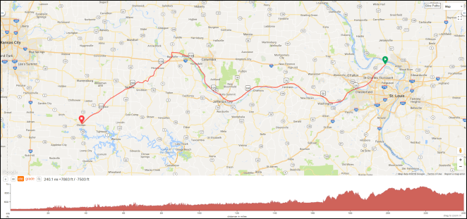 KATY Segment
Distance: 240.1 miles/386.4 km
Total elevation gain: 7,863 feet/2,397 meters
Ride with GPS link
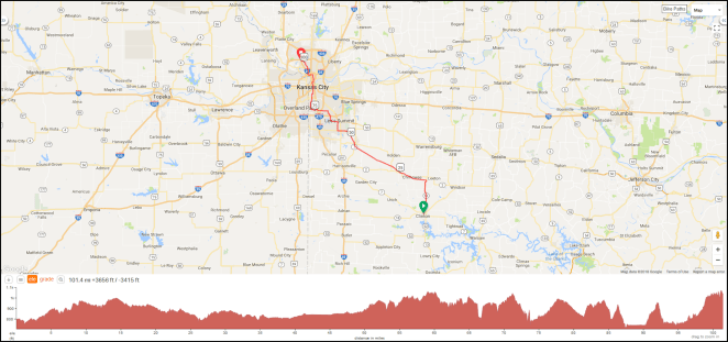 KATY to Kansas City Segment
Distance: 101.4 miles/163.2 km
Total elevation gain: 3,656 feet/1,114 meters
Ride with GPS link
I’ll be posting more detailed information about each one over the coming weeks. If you’d like to ride along on any or all of the days, please let me know. As long as you’re independent and can put up with a guy who stops to take a lot of photos you’ll be fine. While the route is pretty much locked in at this point any suggestion as to points of particular interest or issues in a particular area are appreciated. If you live along the route let me know- I’ll wave as I ride by.
David
I’ll post these without editorial comment for now, and revisit them in the future. What do you think?
I would immediately:
1. Reduce the speed limit on the Trace to 35 miles/55 km per hour in the Nashville, Tupelo, Jackson, and Natchez areas, and to 40 miles/65 km per hour everywhere else.
2. Aggressively enforce lowered speed limits through use of technologies such as photo radar and through high ($300 and up) fines imposed on violators.
3. Establish a $50 permit good for 30 days of travel on the Trace from the date activated for all vehicular and bicycle users.
4. Dedicate all user fees produced by the sale of permits to maintenance of and upgrades to the Trace and do not reduce regular budget allocation based on their receipt.
5. Implement all other reasonable strategies intended to remove locally generated motor vehicle traffic from the Trace, to include high fines ($1,000 and up) for persons operating vehicles without a valid permit.
6. Regrade and repave the entire NTP to add 12 inch/30 cm paved shoulder outside the roadway edge white lines or, alternatively, reduce current 12 foot/3.6 meter lane width to 11 feet/3.3 meters by restriping to create said shoulder.
7. Begin immediate purchase of viewshed easements along the Trace with early priority given to “path of growth” and high visual quality areas.
8. Establish designated bicycle camping areas at existing waysides with restrooms no further than 30 miles/50 kilometers apart.
9. Remove all “modern” wayside and point of interest place name and informational signage and replace with “traditional” NTP signage wherever possible.
10. Rebuild, refurbish or restore as appropriate deteriorated Trace amenities such as nature trails, split rail fencing, interpretive signboards, picnic tables and the like.
David Edgren
April, 2018
Natchez, Mississippi
It has just been impossible between bad and no wi-fi to post to my blog regularly during my Natchez Trace ride. The pics are the big problem. So, in the interim- I’m hoping to have access to a computer in Natchez- here’s my Facebook page.
I generally have a post or two a day there letting you know where I am. Thanks for following along.


![To embiggen this, click here [link]](https://imageshack.com/a/img921/9826/XoRXyS.png)