 After riding the last four miles or so of the C&O Canal Towpath into Cumberland, Maryland the morning of August 16, 2018, the eighth day of my trip, I will start immediately on the Great Allegheny Passage (GAP) rail-trail to Pittsburgh, Pennsylvania. Here’s what that looks like on a map.

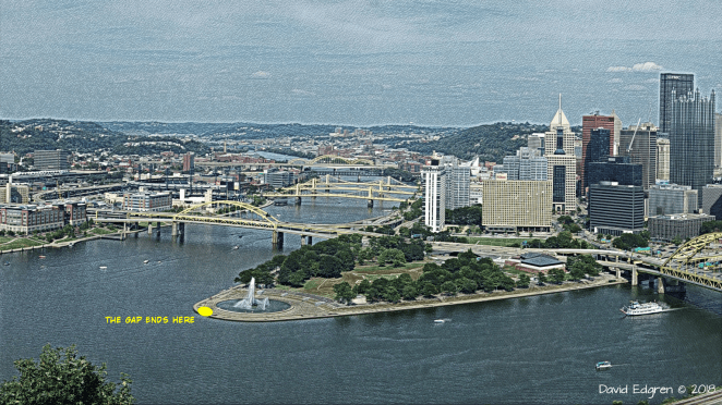
Measured on Ride with GPS the GAP is 150.2 miles/241.7 kilometers from its seamless start at the end of the C&O Canal Towpath in Cumberland to the tip of Triangle Park in front of the fountain at the confluence of the Allegheny and Monongahela Rivers forming the Ohio River in Pittsburgh.
 Base image credit: Public domain
I say measured on Ride with GPS because the Great Allegheny Press’s “Trailguide” [link] says that the GAP is 148 miles/238.2 kilometers long. I’m going to go with the longer figure, as the Trailguide’s number may well be based on the trail ending at a… well, gap that has only recently been completed along downtown Pittsburgh’s Monongahela riverfront.
The GAP and the Towpath’s differing current condition reflects their different origins. Where the Towpath is largely a compacted dirt path that sometimes looks like a one lane road with grass growing in the middle and is made up of level stretches between short inclines at the locks the GAP is a typical rail trail- a repurposed railbed with a rideable gravel surface- often “crusher run”- with an up and down elevation profile.

Whoa!
Looks like up and down. right?
Well, just like you can lie with statistics, you can also do that with elevation profiles. That horrific looking shark-fin of a climb between Cumberland and the Eastern Continental Divide is, in actuality, a gentle, steady just slightly less than two percent grade all the way up. That’s because the Western Maryland Railroad, the tracks of which became the GAP in this area, had a controlling grade- in other words the maximum allowed- on this line of two percent. The reason it looks so daunting on the elevation profile is bcause the “distance” axis is 150 miles/250 kilometers long while the elevation axis is only 2,000 feet/600 meters- four-tenths of a mile/two thirds of a km- tall. The profile thus exaggerates the vertical axis by a factor of about 125 times.
But just because the upgrade is two percent doesn’t mean that cycling this part of the GAP is the same as riding on a nice flat parking lot. That’s a rise of two feet/60 centimeters for every 100 feet/300 meters that you ride. How hard in general is that? I’ve long used in discussions of grade and bicycling a chart put out there by the Bike Hudson Valley club on its website [link], as it strikes me as describing pretty much the way hills affect me.
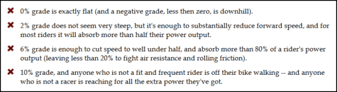
So another way of look at what is said here is that, over the 22 miles/35.4 kilometers of the 1,800 foot/550 meter or so climb between Cumberland at about 600 feet/180 meters above sea level and the summit- the Eastern Continental Divide- at about 2,400 feet/730 meters in elevation, the effort required will be equivalent to a 44 mile/71 kilometer ride on the flat. That’s not insignificant, and when you take into account that the climb is both relentless- there’s no breaks- and is on an unpaved albeit decent surface, well… you get the picture. There’s always the roughly 75 mile/120 kilometer downhill after you reach the divide to look forward to.
As was the case with my discussion of the history of the C&O Canal and Towpath in a previous post, I’ll touch on a few high points and leave it at that, as there is a fairly comprehensive presentation of this information in the TrailGuide. The Baltimore & Ohio (B&O) Railroad was the first to build trackage through the Cumberland-Pittsburgh corridor, completing it in 1871. About ten years later the Pittsburgh & Lake Erie (P&LE) Railroad built a spur paralleling the B&O from Pittsburgh to Connellsville to carry coal and coke to steel mills from large deposits found along the Youghiogheny River, which flows through the area. In the early 20th century the Western Maryland Railroad laid tracks over the crest of the Appalachians between Cumberland and Connellsville, connecting to the P&LE there. By 1975, though, there was not enough freight traffic to sustain both the B&O, which would a decade later become CSX, and the Western Maryland/P&LE line, in that the tracks of each were along most of the route just a few yards/meters from the other. The Western Maryland began abandoning sections of trackage first. The P&LE followed in the the 1980s following the closure of the last large coal mine in the area. By 1991 all of the Western Maryland and P&LE lines had been abandoned.
The creation of the rail-trail that ultimately grew into the GAP began on the late 1970s with the private purchase of 27 miles/43.5 kilometers of abandoned Western Maryland right-of-way followed by ts subsequent donation to the state of Pennsylvania. Construction of the rail-trail began in the state’s Ohiopyle State Park and, by 1986 the first nine mile/14.5 kilometer stretch opened between the park and the north side of Confluence, Pennsylvania. Groups urging construction of more trail mileage were formed along the length of the abandoned lines and began purchasing additional parcels of the right-of-way. In 1995 all the groups merged into the Allegheny Trail Alliance. There was steady progress on assembling the land needed and then building the trail. The Trailguide states that over eighty million dollars has been raised and spent to bring the GAP, less a short section along the Monongahela River waterfront in Pittsburgh, to completion, which was officially declared in 2013. This date marks the opening of a now continuous off-road cycling route from downtown Washington, D.C. to downtown Pittsburgh via the C&O Canal Towpath and the GAP. I’ll note that the state of Pennsylvania and City of Pittsburgh stepped in to build that last piece: the Mon Wharf Ramp, which maintains the GAP off-road around the spaghetti tangle of freeway ramps along the Monongahela just south of the city center. It opens this year. The year 2018 also marks the 40th anniversary of the first acquisition of land for construction of the GAP
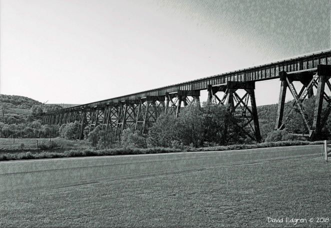
I’ll spend more time describing the various tunnels and high viaducts that are found along the GAP when I complete the daily itinerary that will be posted on this blog shortly.
 Base image credit: Public domain
Suffice it to say for now that there are incredible things to be seen along the length of the GAP in addition to the tremendous physical beauty of the area through which it passes.
The surface of the Towpath, as noted, is generally small gravel or crusher run, solidly compacted. There are a few asphalt sections, particularly as the trail nears Pittsburgh. Nothing I have read gives me any concern that the GAP will present any particular challenge to my loaded touring bike.
As is the case with the C&O Towpath, there are fairly evenly spaced opportunities for the bikepacking cyclist to camp along the Towpath. Along with several commercial campgrounds there are a couple of no-cost “Hiker/Biker” primitive campsites. Once again these latter sites are first come-first served but the etiquette of cyclists making room for a later arrival reportedly holds true. I plan to stay at a municipal campground, an Army Corps of Engineers campground and two Hiker/Biker sites as I ride my five days along the GAP, plus with a WarmShowers host in the Pittsburgh area.
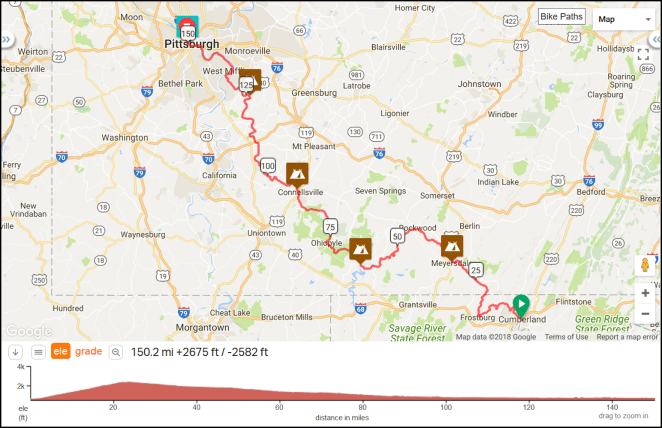
If you draw a straight line between Cumberland and Pittsburgh it heads in an almost perfect northwest direction. This distance crossed by the line is 85 miles/136.8 kilometers, so you can see that, at almost twice as long between the two cities, the Gap winds around a bit. In Cumberland I will still be on the east side of the Appalachian Mountains. The Gap leaves the North Fork of the Potomac River almost immediately then climbs along small streams to the Eastern Continental Divide 23.5 miles/37.8 kilometers past Cumberland. Coming down the other side the GAP follows Flaherty Creek to Meyersdale, Pennsylvania, then runs along the banks of the Casselman River for just over 30 miles/50 kilometers to Confluence, Pennsylvania, then along the Youghiogheny for about 40 miles/65 kilometers to McKeesport, Pennsylvania, then finally along the Monongahela River for 15 miles/25 kilometers to its confluence with the Allegheny River just past downtown Pittsburgh. The Appalachian Mountains are left behind at Connellsville, Pennsylvania at the 90 mile/145 kilometer point, although the terrain around the river valleys is anything but flat along the remaining distance.
A great online resource to accompany the TrailGuide is the Great Allegheny Passage website [link]. Finally, here’s an area map of Pennsylvania and surrounding states with the route of the Gap highlighted in blue.
 © 2018 RandMcNally, fair use asserted
Next up: My itinerary for the first segment of the ride down the Ohio River- from Pittsburgh to Cincinnati, along with some pre-ride comments.

![To embiggen this, click here [link]](https://imageshack.com/a/img921/9826/XoRXyS.png)