 OK, so with the Alaska Big Road Loop Ride pretty much wrapped up I have just under four weeks to get ready for my fall ride: Washington, DC to Kansas City, MO via the C&O Canal Towpath, Great Allegheny Passage (GAP) Trail, Pittsburgh, PA, the length of the Ohio River to Cairo, IL, then up to St. Louis, MO and across that state on the KATY and Rock Island rail trails to KC.
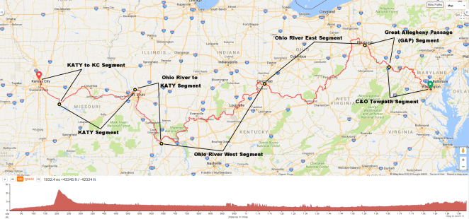
Washington DC to Kansas City MO
Distance: 1,932.4 miles/3,110.0 km
Total elevation gain: 43,345 feet/13,211.6 meters
Ride with GPS link
I’ll leave Alaska on August 5th and finish up in Kansas City on September 30th. Eighty percent of the overnights will be camping with the rest made up of Warmshowers, family and friends and a couple of motel nights. The trip will be unsupported. I will not be bringing anything to cook or dine with (other than a Swiss Army knife and a spoon- ice cream!) so will eat at restaurants/cafes or from grocery stores along the way. I will be riding on average 30 miles/50 kilometers a day on the C&O Towpath, GAP, KATY and Rock Island RR trails and 50 miles/80 km per day on the rest. I’ll take one day a week as a rest/slack day.
Here are the segments.
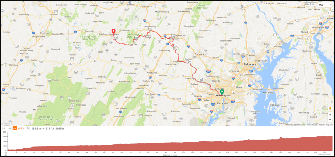
C&O Canal Towpath Segment
Distance: 184.6 miles/297.1 km
Total elevation gain: 1,611 feet/491 meters
Ride with GPS link
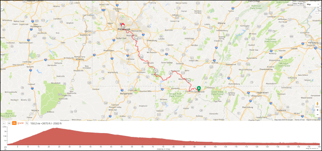 Great Allegheny Passage (GAP) Segment
Distance: 150.2 miles/241.7 km
Total elevation gain: 2,675 feet/815 meters
Ride with GPS link
 Ohio River Segment East (Pittsburgh, PA to Cincinnati, OH)
Distance: 483.1 miles/777.5 km
Total elevation gain: 9,659 feet/2,944 meters
Ride with GPS link
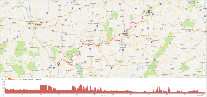 Ohio River Segment West (Cincinnati, OH to Cairo, IL)
Distance: 558.0 miles/898.0 km
Total elevation gain: 16,664 feet/5,079 meters
Ride with GPS link
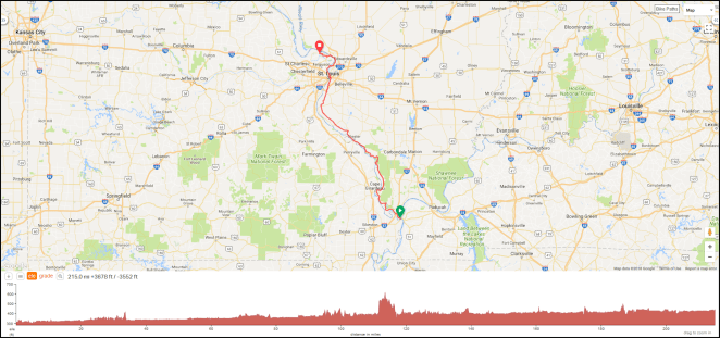 Ohio River to KATY Segment
Distance: 215.0 miles/346.0 km
Total elevation gain: 3,678 feet/1,121 meters
Ride with GPS link
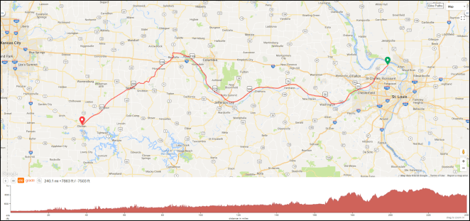 KATY Segment
Distance: 240.1 miles/386.4 km
Total elevation gain: 7,863 feet/2,397 meters
Ride with GPS link
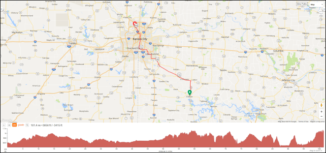 KATY to Kansas City Segment
Distance: 101.4 miles/163.2 km
Total elevation gain: 3,656 feet/1,114 meters
Ride with GPS link
I’ll be posting more detailed information about each one over the coming weeks. If you’d like to ride along on any or all of the days, please let me know. As long as you’re independent and can put up with a guy who stops to take a lot of photos you’ll be fine. While the route is pretty much locked in at this point any suggestion as to points of particular interest or issues in a particular area are appreciated. If you live along the route let me know- I’ll wave as I ride by.
David
