 All good things, as the Sage Jackson Browne once said, gotta come to an end. Having reached the western terminus of the KATY Trail at Clinton, Missouri, the remaining two riding days of my bike trip will be spent getting me to the Barry Road Super 8 Motel that is just a short courtesy van ride from the Kansas City, Missouri International Airport. That’s a distance of just over 100 miles/about 165 kilometers, and I will ride it in two days of almost equal length.

The Ride with GPS route [link] is here.
This segment is unique in that it is both a road segment and a trail segment. I’ll start out on a state highway north from Clinton and then, after riding 15 miles/25 kilometers, enter the Rock Island RR rail-trail [link] and head west-northwest towards Kansas City. I’ll ride the trail the remainder of Day 51 to its current western terminus just past Pleasant Hill, Missouri, and my overnight stopping point is just beyond.
Like the KATY Trail, the Rock Island RR Trail is a Missouri State Park. It is built on the abandoned right-of-way of the former Chicago, Rock Island & Pacific Railroad- the “Rock Island Line.”
![]()
Its formal name is the Rock Island Spur of Katy Trail State Park, but who cares? I’m just glad to be able to ride almost all the way across the state of Missouri on rail-trails.
The last day of my ride I’ll cycle through downtown Kansas City.
 © 2018 RandMcNally, fair use assertedI like riding in big cities. Not all the time, mind you. But one every so often really adds some zing to a bike trip- at least that’s just my opinion. And safety? Well, a couple of years ago when I rode across Manhattan on my ride down the Atlantic Coast from Halifax, Nova Scotia to Key West, Florida [link] I felt safer there than I sometimes do out in rural America. I mean, the cars were barely moving at all and I was. So, there’s that.
 Base image credit: MoBikeFed – Flickr (CC BY 2.0)The terrain on this segment goes up and down within a 350 foot/100 meter band that ranges at the low end from about 750 feet/225 meters above sea level to a high point of about 1,100 feet/335 meters in elevation. The first day, of course, is pretty much a snap, in that most of it is on a former railroad bed. Gotta love those rail-trails. The second day is more challenging. Kansas City has hills! Who knew? But I’ll be on the home stretch with the first motel room of the trip waiting for me, and there’s really no monsters- just a bunch of what look like fairly sharp PUDs (you AT hikers out there know what they are: Pointless Ups and Downs). I’m sure I’ll make it.
As all the segments from the Ohio River East on, I’ll be populating each individual day’s itinerary with information on an ongoing basis over the next couple of weeks, so if you are reading this before September 15th you should come back by or before that date to see the itinerary in a complete form. This will allow me to get all the remaining itineraries up and then work on them at my leisure before I start riding the segment in mid-September. Thanks, as always, for following along.
Day 51 – Friday, September 28, 2018
Clinton Community Center (Mile 1,830.8) to Pleasant Hill City Lake Campground (Mile 1,880.2+0.4 miles off route)
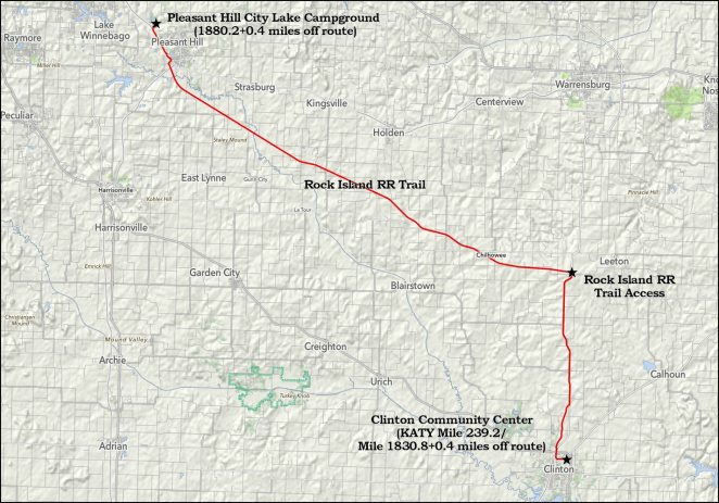
49.8 miles/80.2 km. Ride with GPS route [link].
Day 52 – Saturday, September 29, 2018
Pleasant Hill City Lake Campground (Mile 1,880.2+0.4 miles off route) to Barry Road Super 8 Motel (Mile 1,930.8)

52.2 miles/84.0 km. Ride with GPS route [link].
And that’s it.
