 My KATY Trail segment is the third trail segment of my ride, and the longest of the three. This rail-trail stretches 239.2 miles/385.0 kilometers from Machens, Missouri (essentially a former railroad junction to the north of the St. Louis metro area) to the center of Clinton Missouri, a small city a little more than 65 miles/104.6 kilometers from downtown Kansas City, Missouri. It runs along the abandoned Missouri-Kansas-Texas (KATY) railroad line, hence the name.

The KATY Trail began as the “MKT” Trail in 1982 when Clinton constructed a few miles of trail on a KATY spur into the city that the railroad had abandoned. By late 1980s the line from St. Charles, Missouri to Sedalia, Missouri, much of which had been heavily damaged by flooding along the Missouri River in 1986, was abandoned and subsequently acquired by the State of Missouri with the intention of creating a rail-trail. The first section of that trail opened around Rocheport, Missouri in 1990. Subsequently the Union Pacific Railroad donated its Sedalia to Clinton trackage and the corridor as it stands today was all but complete, less a little more than 10 miles/about 19 kilometers, between St. Charles and Machens. The KATY Trail was fully complete between St. Charles and Sedalia by 1996 and then on to Clinton in 1999. The St. Charles-Machens extension was added in 2011. A second rail-trail, the Rock Island RR Trail, currently branches from the KATY Trail at Windsor, Missouri and extends the rest of the way to the outer Kansas City metro area, making it possible to ride very close to all the way from St. Louis to Kansas City off road on a continuous trail. I will ride a portion of the Rock Island RR Trail in the final short segment of my ride as I cycle to the Kansas City Airport from Clinton.
The entire KATY Trail is a Missouri State Park. It is free of cost to access and use, and the state has constructed numerous access points all along its length. Anecdotally it would appear that the entire trail is fairly heavily used and accounts of through-bike rides are not difficult to find on the Internet. The trail is reportedly crushed limestone all along its length, making for a hard flat surface that is friendly to cyclists.
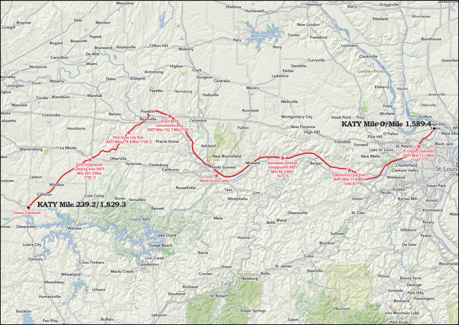
 © 2018 RandMcNally, fair use assertedAs noted, the KATY Trail is 239.2 miles/385.0 kilometers long and you can find the route on Ride with GPS by clicking here [link]. Since it is a former railroad line there are no grades that exceed a couple of percent and Missouri’s terrain in the area it crosses really does not present any challenge in the form of real hills at all. For just over the first 160 miles/about 260 kilometers the KATY Trail runs on bottomland adjacent to the Missouri River. Between St. Charles and Booneville, Missouri the trail runs almost continuously along the base of 100 foot/30 meter tall bluffs on the north side of the river. Often these bluffs take the form of exposed rock cliffs.

From Machens to Booneville and the bridge over the Missouri the KATY Trail rises steadily about 135 feet/41 meters in elevation over the aforementioned 160 miles/about 260 kilometers. That’s climbing about eight and a third inches every mile/15.4 centimeters per kilometer. From the bridge to the end of the KATY at Clinton the climb is more steep- about 120 feet in half that distance, which equates to around 15 inches per mile/28 centimeters per kilometer. This negligible grade is completely hidden by the gentle rolling hills crossed by the former rail line. My calculation of the grades involved indicate grades of between one-half of one percent to one and one-half percent for hills of several miles in length. I will notice them, but I doubt that they will hold me back any appreciable amount.
While the KATY Trail is a state park, it is not developed with any camping facilities.
The slack here is picked up by several state campgrounds in adjacent state conservation areas, by municipal campgrounds and a couple of private campgrounds. My friend and I will spend our first night on the KATY with a Warmshowers host in St. Charles. From there we’ll camp in one state conservation area campground, five municipal or local campgrounds, and a private campground. We’re not taking any rest/slack days while on the KATY.
I’ll ride distances ranging from the longest at 39.2 miles/63.1 kilometers between St. Charles, Missouri and Community Club Park in Marthasville, Missouri and the shortest at 25.5 miles/41.0 km between Pilot Grove City Park and the State Fairgrounds Camping Area in Sedalia, Missouri. My average distance over the seven full and one partial riding days is almost right on my goal of 30 miles/50 kilometers at 31.9 miles/51.3 kilometers each day. My friend and I should roll through this and have a lot of time to look around, enjoy the scenery, and explore interesting places and things along the way.
As with the segments starting back at Ohio River East, I’ll be populating each individual day’s itineraries with information on an ongoing basis over the next couple of weeks, so if you are reading this before September 20th you should come back by or before that date to see the itinerary in a complete form. This will allow me to work on them at my leisure before I start riding the segment at the end of the third week of September. Thanks, as always, for following along.
Day 43 – Thursday, September 20, 2018
Wood River, Illinois [notional] (Mile 1,573.0+1.0 miles off route) to St. Charles, Missouri [notional] (KATY Mile 12.2/Mile 1,601.7)
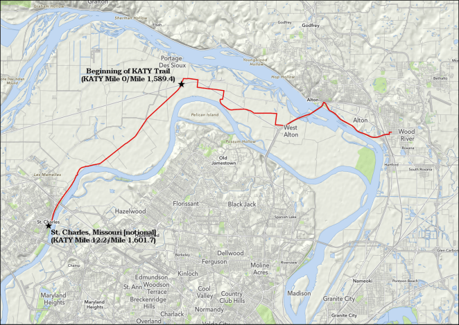
28.7 miles/46.2 km. Ride with GPS route [link]. The last 12.2 miles/19.6 kilometers are on the KATY Trail.
Day 44 – Friday, September 21, 2018
St. Charles, Missouri [notional] (KATY Mile 12.2/Mile 1,601.7) to Community Club Park (KATY Mile 51.4/Mile 1,640.8)

39.2 miles/63.1 km. Ride with GPS route [link].
Day 45 – Saturday, September 22, 2018
Community Club Park (KATY Mile 51.4/Mile 1,640.8) to Steamboat Jct Campground (KATY Mile 84.5/Mile 1,673.9)

33.1 miles/53.3 km. Ride with GPS route [link].
Day 46 – Sunday, September 23, 2018
Steamboat Jct Campground (KATY Mile 84.5/Mile 1,673.9) to Noren Access Campground (KATY Mile 117.0/Mile 1,706.3+0.6 miles off route)
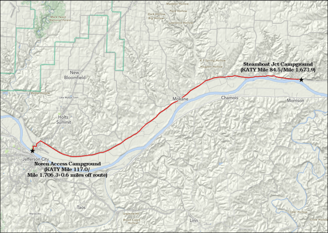
33.1 miles/53.3 km. Ride with GPS route [link].
Day 47 – Monday, September 24, 2018
Noren Access Campground (KATY Mile 117.0/Mile 1,706.3+0.6 miles off route) to Diana Bend Conservation Area (KATY Mile 152.7/Mile 1,742.1)

35.7 miles/57.5 km. Ride with GPS route [link].
Day 48 – Tuesday, September 25, 2018
Diana Bend Conservation Area (KATY Mile 152.7/Mile 1,742.1) to Pilot Grove City Park (KATY Mile 178.0/Mile 1,768.3)

25.3 miles/40.7 km. Ride with GPS route [link].
Day 49 – Wednesday, September 26, 2018
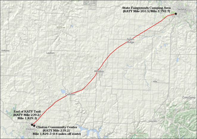
Pilot Grove City Park (KATY Mile 178.0/Mile 1,768.3) to State Fairgrounds Camping Area (KATY Mile 203.5/Mile 1,792.7)
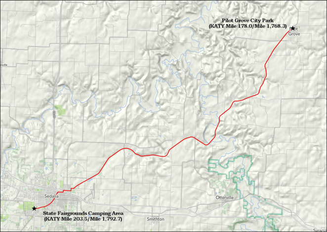
25.5 miles/41.0 km. Ride with GPS route [link].
Day 50 – Thursday, September 27, 2018
State Fairgrounds Camping Area (KATY Mile 203.5/Mile 1,792.7) to Clinton Community Center (KATY Mile 239.2/Mile 1,829.3+0.4 miles off route)
35.7 miles/57.5 km. Ride with GPS route [link].
Two days left to ride!

Nice!! Ive done some short rides on the Katy in 2017, Jeff City, and MKT trail. Nice rides!
Sent from Yahoo Mail on Android
LikeLiked by 1 person