 This is the third of the four “road” segments of my Washington D.C. to Kansas City, Missouri ride. It is basically a way to connect the end of the Ohio River West segment up with the KATY Trail segment and, while it runs through some interesting country, I won’t be dallying along the way. Besides, it is the same area that I rode through in the other direction in the fall of 2017 on my ride down the length of the Mississippi River [link], so I’ve seen it fairly recently in any event.

The entire segment is “only” 215 miles/346 kilometers long and you can find the route on Ride with GPS by clicking here [link]. Unlike last fall’s Mississippi River ride I will stay, except for crossing over to downtown St. Louis and taking the Riverfront Bike Trail up to the Old U.S. 66 Chain of Rocks Bridge, entirely on the Illinois side.

I can’t say that I won’t stop and look at a couple of things along the way- I do want to take a look around Fort Kaskaskia just north of Chester, Illinois as I passed it up in 2017 to cross to the Missouri side and see Ste. Genevieve and Kaskaskia Island, and the Gateway Arch in central St. Louis to me is irresistible- but, as noted, I’m more or less riding the segment because I have to.
A huge benefit of riding on the Illinois side of the Mississippi River where the river forms the border between that state and Missouri is the prevalence of bottomland to ride on in Illinois.

This provides an almost parking lot-flat ride for much of the distance between Cairo and St. Louis, whereas on the Missouri side just about the corresponding distance is hill after hill after hill. These hills aren’t just bumps, either. They are more like the scariest rollercoaster you can imagine. There’s a few climbs that I’ll face on the Illinois side but, trust me, they are nothing like what are on the other side of the river in Missouri.
I will have ridden just about 1,000 miles/1,600 kilometers along the Ohio River and dropped just about 400 feet/120 meters in elevation between Pittsburgh, Pennsylvania and Cairo over that distance. On this segment I’ll be climbing again, ever so slightly. The Mississippi at St. Louis is just about 75 feet/22.5 meters higher in elevation than at Cairo. That’s a whopping gain of just about four inches for each mile I ride/6.5 centimeters per kilometer. Like I said- flat.
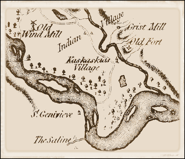
One thing I will be sure to do is take a good look at the site of Fort Kaskaskia across the current channel of the Mississippi River from Kaskaskia Island which, as noted, I crossed into Missouri to visit last year. Reportedly the site of the old fort has a commanding view of the river and the area where Illinois’ first capital city was located. I’ll spend the night at the Illinois State Park campground there. I’ll also stay in a municipal campground, two private campgrounds and, in Wood River, Illinois, with a Warmshowers host who has become a friend and who will ride the KATY Trail with me over the next week or so. I’m planning to take my 66th birthday, September 18th, as a rest/slack day.
I’ll ride distances ranging from the longest at 63.2 miles/101.7 kilometers between New Grand Chain Lodge & Campground and Thebes Landing Campground (note, though, that only 32.0 miles/51.5 kilometers of that is in the segment; the remainder is part of the Ohio River West segment and the day: Day 37 of the ride, is described in that segment’s itinerary) and the shortest at 29.5 miles/47.5 km between Wood River and St. Charles, Missouri on Day 43. This day is split between 17.5 miles/28.2 kilometers ridden on this segment and the remainder on the KATY Trail segment, and I have accordingly covered the day along with the rest of the KATY Trail itinerary. My average distance over the six full and partial riding days will be the shortest of my “road” segments: 35.8 miles/57.6 kilometers each day. The terrain, as described above, is basically flat. The largest hill is off-route: the just over 200 foot/60 meter climb out of the river valley on Day 28 up to Fort Kaskaskia State Park. As far as hills go that’s about it.
As with the Ohio River East and West segments, I’ll be populating each individual day’s itineraries with information on an ongoing basis over the next couple of weeks, so if you are reading this before September 15th you should come back by or before that date to see the itinerary in a complete form. This will allow me to get all the remaining itineraries up and then work on them at my leisure before I start riding the segment in mid-September. Thanks, as always, for following along.
Day 38 – Saturday, September 15, 2018
Thebes Landing Campground (Mile 1,406.3) to Devil’s Backbone Campground (Mile 1,443.6)
37.3 miles/60.0 km. Ride with GPS route [link].
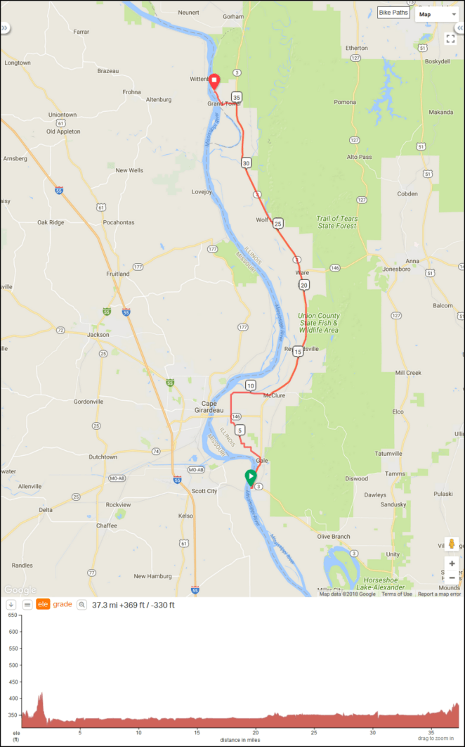
Day 39 – Sunday, September 16, 2018
Devil’s Backbone Campground (Mile 1,443.6) to Fort Kaskaskia State Park Campground (Mile 1,484.1+0.9 miles off route)

41.4 miles/66.6 km. Ride with GPS route [link].
Day 40 – Monday, September 17, 2018
Fort Kaskaskia State Park Campground (Mile 1,484.1+0.9 miles off route) to Cahokia RV Parque (Mile 1,543.8)
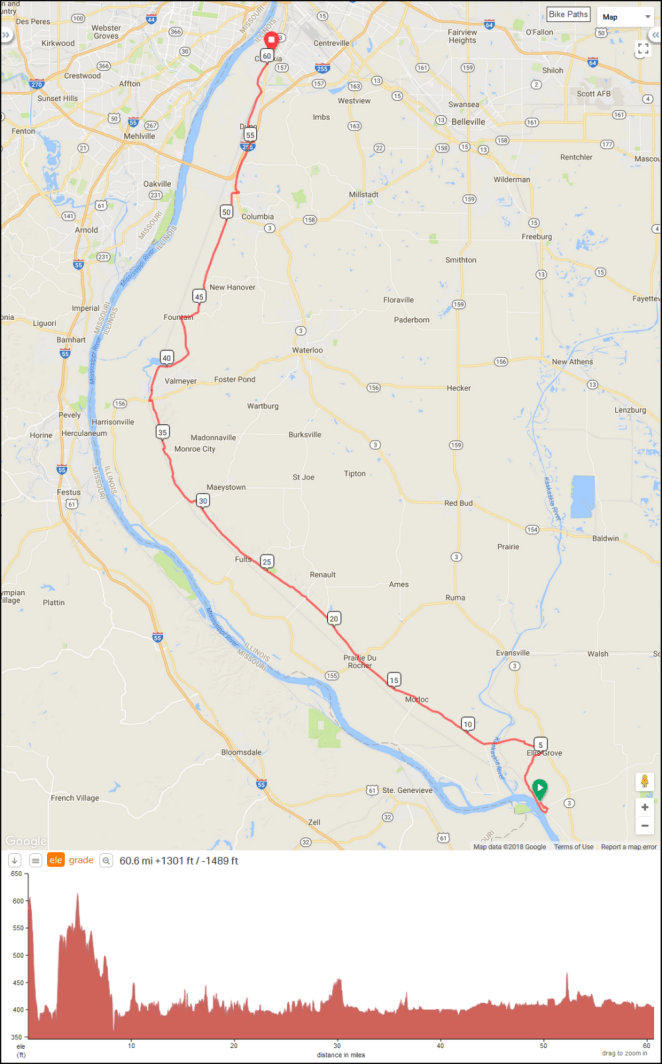
60.6 miles/97.5 km. Ride with GPS route [link].
Day 41 – Tuesday, September 18, 2018
Rest/Slack Day at Cahokia RV Parque
Day 42 – Wednesday, September 19, 2018
Cahokia RV Parque (Mile 1,543.8) to Wood River, Illinois [notional] (Mile 1,572.3+1.0 miles off route)
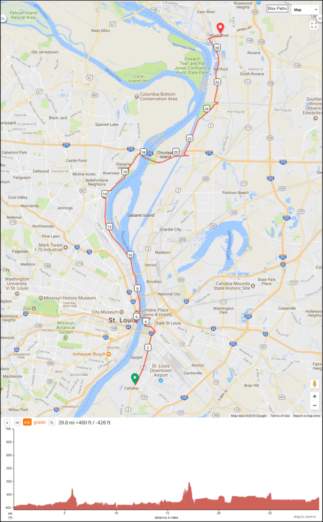
29.8 miles/48.0 km. Ride with GPS route [link].
