 days left to go.
 Our first week on the road will look like this.

On August 25th Gary and I will arrive at the campground at Itasca State Park [link]. We’ll get a good night’s rest and, bright and early on the 26th, get up, pack our bikes and head for the Mary Gibbs Mississippi Headwaters Center [link] and the source of the Mississippi River a couple of 100 yards/meters away. We are, at that point, at Mile Zero of our ride, with 52 days and about 2,400 miles/3,865 kilometers left to go down the road. The Mississippi River leaves Lake Itasca at 1,475 feet/450 meters above sea level. So, since we’ll wind up at the river’s delta out in the Gulf of Mexico at the end of our ride, it really is (almost) all downhill from here. It’s also a bit amusing that, on a ride along a river that passes through most of the land mass of the central United States for about 1,300 miles/2,090 kilometers north to south from just below the Canadian border to the Gulf, we start by riding due north.
The first week is certainly mostly downhill. St. Cloud, Minnesota, which we’ll reach on September 1st and rest for a day in on the 2nd, is at about 1,000 feet/305 meters above sea level, so the river drops 475 feet/145 meters over the first 322 miles/518 kilometers of our ride. That’s just a little less than one-third of the Mississippi’s total descent on its way to the Gulf and we still have over six weeks and over 2,000 miles/3,200+ kilometers left to go. On the other hand, do you think that it’s even possible to notice a grade of 18 inches/45 centimetres of vertical change in a mile/1.6 kilometers? Me neither. A steady one percent grade of descent over the course of our entire ride would be a loss of 24 miles/38.5 kilometers in elevation. The river drops at a uniform grade of around one-hundredth of one percent- about six inches/30 centimeters per mile/1,600 meters between its source and its mouth, so the river mileage followed during the first week of the trip is about three times that grade: three one-hundredths of a percent. Effectively flat by any measurement.
I’ve noted 50 mile (80 kilometer) intervals on the map above. We planned our ride in roughly 50 mile/80 kilometer per day increments. As we zeroed on on specific places to stay and see most of the days expanded to somewhere between there and 60 miles/96 kilometers, with a few longer days here and there, and particularly as we reach the parking lot-flat terrain of most of the south.
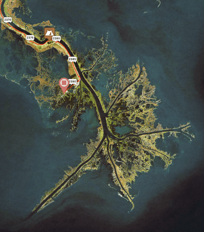
The destination on the first day is Stony Point Resort [link], a fancy RV park and campground on the south shore of Cass Lake. We’ll have ridden 54.3 “official” miles/87.4 kilometers on our maiden day on the road and crossed the Mississippi River 10 times in the process. The river during that time will grow from a 10 foot/three meter wide brook to a respectable stream some 50 feet/15 meters across. Along the way we’ll pass through the city of Bemidji, where we’ll stop at the Northern Bicycle Shop [link] for some Day One adjustments, the Paul Bunyan and Babe the Blue Ox statue [link] for our daily dose of kitsch and probably somewhere for lunch. Up to Bemidji we’ll be riding on quiet two lane county roads through open rolling countryside. On the other side of the city we’ll return to minor roads and reach the most northerly point on our trip- just 100 miles south of the Canadian border- on our way to the town of Cass Lake and our stop for the night.
On September 27th, the second day of the first week of our ride, we will cycle 53.1 miles/84.5 kilometers to the Blueberry Bowl, a bowling alley and bar [link] a few miles north of the town of Deer River. The owners have graciously offered us a place to camp next to their business. We’ll cross the river just one time getting there on a combination of US Route 2, the main non-interstate highway across the northern United States, and little-traveled county roads through the woods to the north of US 2 that run along the Mississippi and the various lakes it flows through. We’ll pass Lake Winnebigoshish, which apparently takes its name from a rude Winnebago Native American word for the quality of its water, the fourth largest lake in this state of 10,000 of them. We’ll also ride by the Big Fish Supper Club [link] where we’ll see a 65 foot/20 meter long concrete Muskie (Muskellunge) featured in the movie “National Lampoon’s Vacation” and probably stop for a photo or two. We’ll also ride through the uniquely named hamlet of Ball Club not long before we reach Deer River and our stop for the night. I forgot to ask Gary if he would carry my bowling ball for me.
The 28th calls for us to ride 46.4 miles/74.7 kilometers generally southwest to local-government owned Jacobsen Campground [link], where there are 10 semi-primitive campsites tucked into a bend of the river. We’ll start out heading south for the first time on the ride, picking up US 2 for a short stretch out of Deer River, then on county roads through alternating woods and field over the gently rolling terrain that we’ve seen since the start of the ride. We’ll cross the Mississippi River three times, the last two as we ride through the small city of Grand Rapids, which will offer us the first fast-food franchise dining opportunities we’ll have seen since Bemidji just in time for lunch. There is also a bike shop here, Itasca Trail Sports [link], in case we have developed any issues since leaving Bemidji. The rapids the city was named for were tamed by a dam creating Paper Mill Reservoir many years ago, but it appears as we leave the downtown we’ll have scenic views of the river, now about 100 feet/30 meters wide, from a pleasant bike path. Leaving Grand Rapids the minor road we will follow leads us another 20 miles/32 kilometers or so through increasingly wooded and often marshy land not far south of the river to the campground. Most of the way to the campground we’ll finally pass south of the place we started at the headwaters. The day appears to be pretty kitsch-free, although if you are local to this area and know of any, please call it to our attention.
We’ll stay the night of the 29th on the outskirts of Aitkin, Minnesota in a county-run campground: Aitkin Campground [link] located on the south bank of the Mississippi. This 48.2 mile/77.6 kilometer stretch initially heads south on county roads through densely wooded land north of the river then turns to the southwest about 20 miles along. We will only pass near one small community until we reach Aitkin at the end of the day; that is Palisade. Google Maps says that there is a cafe there, and thus probably lunch. Other than a brief stretch of about a mile/1.75 kilometers on US Route 169, the road remains lightly-traveled two lane blacktop all day. We’ll cross the Mississippi River on the northern outskirts of Aitkin and ride a couple of blocks through a residential neighborhood before reaching our stop for the night after this second sub-50 mile/80 kilometer riding day in a row.
The second to last day of August, the 30th, will see Gary and I riding the longest distance on the trip so far, but not by much: 55.3 miles/89 kilometers. There’s a McDonald’s in Aitkin…
…mmmm, sausage biscuits…
…and then we’ll backtrack north on the road we entered the city on back across the Mississippi River. The subsequent 45 mile/72.4 kilometers into the large city of Brainerd, Minnesota is our first major deviation from the Mississippi River Trail (MRT), which we have pretty much followed closely to this point. We routed our trip this way here because the roads we will take are less-traveled and seem to more closely hug the river. We’ll see. About six miles/10 kilometers north of Brainerd we’ll pick up the Paul Bunyan Trail [link], a paved rail-trail, as it drops down to that city from Bemidji. We’ll leave the trail on the northern outskirts of the city to follow the river into the downtown, where we’ll cross the Mississippi River twice in a matter of a few blocks. There is pretty much everything in Brainerd shopping-wise a bicycle tourist could want, including two bike shops, Muddy Bikes [link] and Easy Rider Bicycle & Sportshop [link]. The ride out of the downtown to the south is along the west side of the river and the last six miles/10 kilometers, reached just after we cross the Mississippi River for the fourth and final time for the day, are on the recently completed southernmost stretch of the aforementioned Paul Bunyan Trail, which carries the MRT in this area. Our stop for the night is at the campground at Crow Wing State Park [link], which takes its name from the Crow Wing River that joins the Mississippi here. This appears to be the third kitsch-free day in a row.
We’ll end the month of August by riding south from Crow Wing State Park 64.4 miles/103.6 kilometers more or less due south to the city of St. Cloud which, outside of the Twin Cites of Minneapolis and St. Paul that we’ll ride through the following week, is the largest city we’ll see in Minnesota. The first 17 miles/27.4 kilometers south of the park is nothing to write home about as it is down US Route 371, a four lane divided highway that is the only paved road along the river on our route in this area. Nothing to write home about except for, just outside the park, yet another giant statue of Paul Bunyan [link], this time sans his blue ox, located at a welcome center where we turn on to US 371. Our kitsch quota renewed, we will pedal quickly and carefully down the wide shoulder of this hopefully not that busy highway. We’ll leave US 371 just before the exit to the Minnesota National Guard training base Camp Ripley [link]. We’ll cross the river for the first time for the day here and then, across from the main gate of the post, head south on a county road down the west side of the Mississippi to the city of Little Falls, where there is a full range of local businesses and services, to include the Touright Bicycle Shop [link], which I will have to stop at to say hi just because it is the first bike shop along the route that bills itself as a Surly dealer and because we get to cross the river two times here on a short “there and back” jog from the route. We’ll leave Little Falls on a county road that runs along the river headed south and cross the Mississippi three more times on local roads before we reach the small village of Rice about 50 miles/80 kilometers into our riding day. It doesn’t look like there’s much to see in Rice, so we’ll take county roads, this time on the east side of the river, for 10 miles/16 kilometers south to the city of Sartell, then through residential neighborhoods along the river through the city of Sauk Rapids and then into St. Cloud, where we will stay at a residence with friends that night and the next, as we have planned September 1st as a rest/slack day.
The 1st closes out our first week on the road and, as noted, is a rest day. We have built such days, about one each week, into our itinerary for a couple of reasons. First, because we probably will need a break after a week or so’s worth of riding. A close second is to give us a “make-up,” or slack day just in case we get delayed for some reason- mechanical difficulties, bad weather, hellish winds, those sorts of things. In the event any of that happens, we’ll just cross our fingers that it doesn’t delay us by more than a day and then we’ll skip the slack day and then be back on track. If that doesn’t happen, and we really hope that we don’t have to do that, we can use the day to check out local places of interest and to do some bike maintenance. In St. Cloud, there appears to be a wealth of interesting things to see- but this isn’t a tourguide, so I’ll leave that to others to describe, probably better than I could ever do anyway. There are three bicycle shops available in the city near our route: Rod’s Bike Shop [link], Fitzharris Ski, Bike & Outdoor [link], and Erik’s Bike, Board & Ski [link], so any needs we have in that regard are likely to be addressed. Anyway, describing our first week on the road has been fun. We’ll post the second week in a few days so we don’t get too far ahead of ourselves.
Thanks for coming along on our ride via this blog- catch you later!
David
 days to Lake Itasca!

 days until the start!
 days left to go!!

 Two weeks from today!
 days left to go!!
 days left!
 days left.