A Routing Probl… err, Challenge

Wheel full 70pxMy great friend and true Southern gentleman Kevin Slark commented on my latest routing post [linkie] over on my facebook page [linkie] to let me know that crossing the Mississippi River from Louisiana to Mississippi at Vicksburg might not be an option.

KS Facebook comment 01

Wheel full 70pxReal Life, as it tends to, intervened and I really didn’t have a chance to get back to this issue until today.

Wheel full 70pxHere’s what Kevin is talking about.  The 86 year old bridge that carried US highway 80 across the Mississippi River just west of Vicksburg

Old US 80 Bridge at Vicksburg 800px

Image credit: Wikipedia

is currently closed to all traffic, vehicular, bicycle and pedestrian, except for a couple of days of the year when it is opened for special events, such as a community bike ride this year on October 1st [linkie].  The bridge carries a rail line and has very narrow vehicle lanes

Old US 80 Bridge Deck 800px

Image credit: Vicksburg Post

and the railroad operating the line has repeatedly objected to reopening the bridge to regular bicycle and pedestrian use despite efforts by cycling and walking enthusiasts and advocates to have this done [linkie].  Unless I can get my crossing declared a special event, it does not look good for me to be able to use the bridge towards the end of August in the fourth week of my ride.

Wheel full 70pxThe old US 80 bridge was replaced as the primary Vicksburg area Mississippi River crossing in 1973 by the Interstate 20 bridge

I-20 Bridge at Vicksburg 800px

Image credit: Wikimedia

which is now, interestingly enough, exactly half the age of the other structure.  The two run parallel to each other,

Mississippi River Bridges at Vicksburg 800px

Image credit: Vicksburg Post

and the pier spacing is exactly the same to facilitate the passage of barge traffic up and down the Mississippi.

Wheel full 70pxBut the bottom line is that the State of Mississippi does not allow bicycle traffic on any of its Interstate Highways, period, and my use of the I-20 bridge is thus not possible.  I called the Mississippi State Bicycle (& Pedestrian) Coordinator [linkie] today and confirmed that there was no exception for this particular crossing.  She said that there was not, but encouraged me to contact various groups concerning my desire to use the old US 80 bridge.  I will follow up on that tomorrow but, as noted, I am not hopeful.

US 80 300px

Wheel full 70pxKevin apparently anticipated this result, as he recommended an alternative crossing.

KS Facebook comment 02

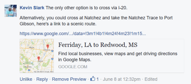
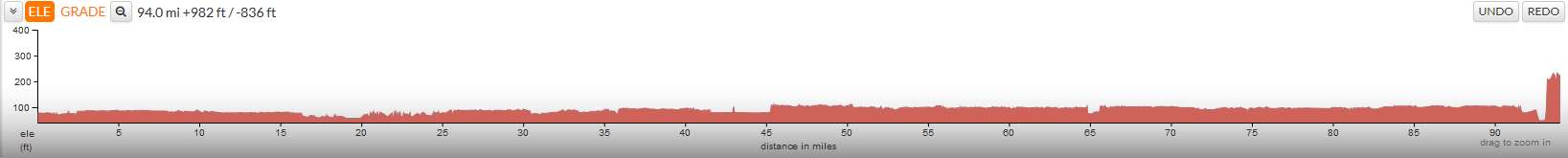
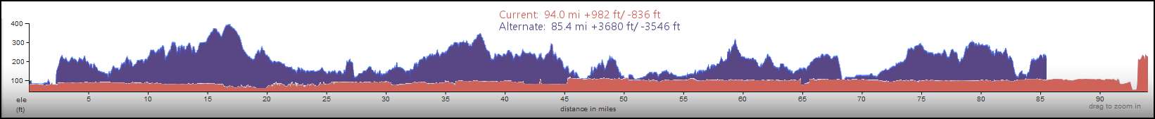
Crossing at Natchez would not involve a huge modification to the route I have planned.  It replaces a 94 mile/151 kilometer stretch from MP 997 to MP 1091 with an 85.4 mile/~137 kilometer alternate.  The red line is the current route and blue is the alternate.

Current Route Natchez-Vicksburg

The alternate is surprisingly (to me, anyway) about ten percent shorter, even though it doesn’t look it.  Here’s the above map reversed, with the alternate in red and the current route in blue.

Alternate Route Natchez-Vicksburg

Most of the alternate route’s mileage is on the Natchez Trace [linkie], which is an amazing low speed (45 miles/~70 kilometers per hour) scenic national parkway in a beautiful right-of-way.  Heather and I have biked this stretch in the late 1990s on our Burley Rock’n’Roll tandem [linkie].  I seriously considered incorporating it into the original route for this trip.

Wheel full 70px
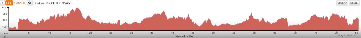
The reason I ultimately didn’t can be seen on the above map.  Note that the terrain on the Louisiana (left) side of the Mississippi is smooth.  East of the river, though, the landform changes pretty radically into low but steep hills cross-cut by deeply incised streams.  Here’s an elevation chart of the current stretch

Current Route Elevations Natchez-Vicksburg

and of the alternate done at the same vertical scale.

Alternate Route Elevations Natchez-Vicksburg

Here’s the two superimposed.  Click on any of the three charts to embiggen.

Comparison Elevations Current Alternate Natchez-Vicksburg 800px

Wheel full 70pxSo that’s a little sooner than I’d planned to start doing hills.  But I’ll have just about 1,000 miles under my belt before I get to them, so they shouldn’t be too bad.  Hey- maybe I can still become an event and cross the old US 80 bridge.  But if not, well… I have a plan!

David Edgren


Mapping the Revised Route

Wheel full 70pxI’ve spent some time working with Ride with GPS [linkie] in revising my cross-the-country route and working out final maps.  Here is the latest all-in-one map

ypydz3

and each of the five stages.

7nwkqz

vxsge5

mcd8zz

e9kyzc

sy8wo6

Wheel full 70pxStage I through IV is each 1,000 miles/1,600 kilometers,  Stage V is about 139 miles/75 kilometers.  Click on any of the map images to see a full size map.  The full size stage maps are all of equal scale to the others.  Here are links to the maps on Ride with GPS, which you can enlarge to street level detail.  You can navigate between stages directly using the linkie on the right side of the map.

David Edgren

The Method to My Madness

Wheel full 70pxFor those of you who have looked at my route on Ride with GPS [linkie] and wondered

img_2485

let me see if this helps.

Wheel full 70pxI know my route is certainly not the most direct way to get across the country.

Boundary Map not Annotated - 800px

It stays way south for a long time, makes a right-hand turn up the lower Mississippi Valley, then finally starts heading northwest in Arkansas.  Relentlessly northwest, almost to the Canadian border.  Then I’ll head west again, dipping down into Oregon before the last northwest dash to the Pacific Coast.  The distance between the two places is only about 2,500 miles/4,000 km as the crow flies [linkie].

AstheCrowFlies

Wheel full 70pxBut I’m not a crow.  I’m a 63 year old fat guy with, as my grandpa used to say, “arthur-itis.”  I haven’t really pushed myself in years.  I found out in 2014 when I tried to walk the Cotswold Way in England [linkie] that my knees just won’t let me walk any meaningful distance>  But I can cycle all day long at 10 miles/16 km per hour.  I mean, does that make any sense?

Wheel full 70pxSo I’m setting some goals at the outset.  I base my planned mileage (kilometerage?) on riding six of seven days each week.  I won’t necessarily need to take advantage of that day, but it’s there if I need it.  So the ride goes like this.

  • Week one: 40 (and a bit extra) miles/65 km each day for 250 miles/400 km total.
  • Week two:  50 miles/80 km each day for 300 miles/480 km total.
  • Week three:  66 (and a bit extra) miles/100 km each day for 400 miles/640 km total.
  • Week four on:  75 miles/100 km each day for 450 miles/720 km total.

On my Baja and other Pacific Coast rides, I was doing 75 miles/120 km a day by day four.  So I think I’ve built in a reasonable cushion, given that those rides were 20 years ago.  So I planned my route with, so to speak, an ace in the hole…


Annotated elevation chartClick to embiggen

The first four weeks of the ride are essentially flat.

Wheel full 70pxOh yeah, there’s some up and down terrain, especially in week four as the route starts up the valley of the Arkansas River.  But not much.  And I think I can (or will be able to by that point) deal with it.

David Edgren

Some Progress…

Wheel full 70pxWell, OK. It’s been almost a full month since my first post in this blog, and everyone who has seen it is probably wondering what I’ve been up to. I’m pleased to be able to tell you that things have been moving forward, although not as quickly or as smoothly as I would have liked. Time has been spent on a couple of false starts identifying a bike to ride for the trip but, as l’ll describe in further detail below, I think we are finally on top of that critical piece. I have also spent a lot of time refining the planned route on Ride with GPS, mainly in getting it into a form where I can talk specifics with local bike clubs and knowledgeable people in advance of setting out. So here’s where we’re at as of today.

Wheel full 70pxAfter doing quite a bit of research on the web and as a result of being in touch with a couple of bike builders, I have decided that the best bike available for this trip is a Surly Long Haul Trucker outfitted with disc brakes and a number of other components intended to bulletproof it as much as possible. Just about everyone I have talked with has recommended the Surly after I have described the trip as a bike that can be worked on almost anywhere and which has the quality and durability that I will need.

Wheel full 70pxSo on Friday of last week I made the hour drive to Portland to the “Bike Gallery” bicycle shop location on Sandy Boulevard.


I spoke with a very helpful and knowledgeable sales person named Darrin for about an hour concerning my plans for the trip and the way that I thought I needed the bike built and outfitted. Darrin is certainly far more knowledgeable about the current state of the art of bicycle components and gear than I am since my last long-distance ride was in the mid 90s and, as a result, he made several very helpful recommendations. I was surprised to find though, that I was still able to speak in “bike talk” and not feel like a complete fool. I am watching for a detailed part/component list and estimate that he was going to try to get to me today. Once I have it, I will post it for your comments. My hope is that I will be able to place a deposit on ordering the bike later this week. I am also hoping that we can keep the cost to under three grand, which would allow me to eat something other than roadkill along the ride.

Wheel full 70pxAs for route planning, I now have the entire route broken down into 50 mile/80 km segments.  There are 81 of these, with the entire route now coming in at just under 4,068 miles.  I stress that this is an “almost final” route, as I am hoping that there will be feedback that will allow me to further refine it as close as possible to perfection.  If you see a change that you think would be a good one, please don’t hesitate to recommend it.  Don’t be disappointed if you do propose a change and it takes me a while to get to it, as I plan to accumulate them and then relook the route all at once, probably some time in June.

Wheel full 70pxIt has at times seemed like I have been spending days (on a slow Internet connection… the horror, the horror) using Google’s satellite view to look for paved minor roads in states like Kansas and Idaho. Now that the segments are created, I can begin to detail them in Ride with GPS with information that will take my cue sheets beyond “straight ahead” or “slight left onto US 95.”  I figure that this will take me a couple of more weeks to complete.

Wheel full 70pxI’ll be writing much, much more about route planning in the near future.

Wheel full 70pxI’ve also begun a comprehensive list of “to-do’s.” This post has already run longer than I planned, so that will be the subject for the next one, coming up shortly.

David Edgren

Hello there…

Wheel full 70px…and welcome to the blog I have started to document the planning for and undertaking of my solo unsupported transcontinental bicycle ride from Atlantic Beach, Florida to Pacific Beach, Washington.  I’m calling it the Beach 2 Beach Trans-Con, or b2b for short.

Relief Map Annotated - 800px

Here’s the Ride With GPS route I have created for it [linkie]I am in the process of fine tuning the route and breaking it into 50 mile segments, which I will make available in future posts on this blogAs of May 9th, the initial “tuning” is done and the 50 mile segments of the route are posted on Ride with GPS.

Wheel full 70pxMy current plan, subject to change, is to start the ride the last week of May following attending my daughter’s wedding in Rhode Island .  Based on that start date I would reach the left coast sometime in the second week of August, around 60-65 riding days later. The start date now is likely to fall somewhere in the last 10 days of July.  The reasoning behind this will be addressed in an upcoming post.  The “About Me” post here [linkie] will give you some idea of the considerations that have gone into making the trip.

Wheel full 70pxI’ll be starting on the Atlantic Coast east of Jacksonville, cross the State of Florida, then bike along the Gulf Coast until I reach New Orleans.  From there I’ll pick up the Mississippi River and turn north, riding mainly on levee tops to the mouth of the Arkansas River.  This first 1,000 miles of the ride is almost flat, and will be a great period during which to recondition long disused muscles.  Once at the Arkansas, I’ll turn northwest and follow the Arkansas River into central Kansas, where I’ll then make a jump over to the Platte River Valley in Nebraska.  I’ll ride along the North Platte into central Wyoming, then up over the Continental Divide and into Idaho through Jackson and the Grand Tetons.  I’ll miss entering Yellowstone National Park by that much, but you can’t do everything.  Once in Idaho the road will turn north and I’ll be in Montana for a short time before finally turning west and heading for the Columbia River Valley.  On reaching the Columbia, I’ll dip down into Oregon for a few miles then return to my final destination state: Washington, for a long (mostly) downhill run along the north bank of the Columbia River  to Vancouver.  The last two days of the ride will be spent reaching the Pacific Coast and the hamlet of Pacific Beach, where I’ll dip my tires in salt water for the second time of the trip.

Boundary Map not Annotated - 800px

Wheel full 70pxThe next couple of blog posts will deal with the issue of finding a bike to make the ride on.  I hope you will find what I write here informative and interesting, and welcome you in advance to comment as you would see fit.  Please speak up in particular if you think I could be doing something better in planning and preparing.  Your opinions are absolutely appreciated, whether I wind up agreeing with them or not.  Please speak up sooner rather than later, too.  I’m on a really tight time frame, and decisions about things- in particular equipment and accessories- will be getting made on almost a daily basis starting very soon.  I would also appreciate input as to location-specific routing, as well.  I will be writing various cycling clubs and bike shops asking for comments about the route I have come up with, but there’s nothing like hearing from someone who has detailed info about a better/more scenic/more bike friendly routing.

Wheel full 70pxThanks for coming along for the ride.

David Edgren