Two Things I Should Have Left Home

Wheel full 70px As I gain experience using the gear I have brought with me, I am figuring out the things I will be sending home at the first opportunity- in other words when I’m back in the ‘States.  These two items will go for sure.

image

Wheel full 70px The bottom item is a solar panel.  All I can say is, “What was I thinking?”  A cool item to have, but not all that useful given that I have two high  capacity batteries I have figured out how to charge most every night.  At between 1-2 pounds/~.5-1 kg, it’s not the biggest deal, but it does take up space in a pannier.

Wheel full 70px The top item is a nifty little tripod.  It would be nice to use along the way, but I am not going to unpack a pannier each time to get at it.  Once I get to where I’m headed in the evening, playing at being Ansel Adams is the last thing on my mind.  So you get handheld, I’m afraid.  A great item to throw in the car on a trip, though.  I’ll save 2-3 pounds/~1-1.5 kg and significant space in a pannier.

Wheel full 70px I’ll know next time.

The b2b Trip – Week #1

Wheel full 70px For those of you following along at home, it’s been a whole week that I’ve been on the road.  In that time, I’ve ridden 178 miles/~290 kilometers.  I’m making quite a bit of progress down the Southeast Coast of Nova Scotia.

image

Wheel full 70px I haven’t added it up with any precision, but a good ballpark elevation gain so far is about 10,000 feet/3,000 meters.  Not bad for an old guy, eh?

Wheel full 70px Here’s a bit closer look.

image

Wheel full 70px I have stayed on roads as close to the shore as I can, which has been both a blessing and a curse.  It’s great that, when those roads are level, they are absolutely flat, running just a bit above the high tide line, and sometimes for quite a ways.  The Nova Scotia coastline is as scenic as it gets, and I have hours every day to enjoy it.  Often these roads have minimal traffic, so I get to see the sights without worrying about getting knocked down by an inattentive driver.

Wheel full 70px On the minus side, when these local roads are hilly, they aren’t kidding.  When they were laid out, the cuts and fills of modern highway design weren’t in the cards yet, and there has been little effort to bring them up to modern standards.  The pavement is also often rough or otherwise in poor shape.  There are also long stretches without stores or restaurants for food or bathroom breaks.  You just can’t have everything.

Wheel full 70px I had planned to ride more miles each day.  What’s doing those plans in is my stopping every little bit to take photos.  I just can’t help it.  I’m probably also best off not trying to kill a bunch of miles/km a day at this point.  I am able to easily ride another 10 miles/16 km a day right now, I’m pretty sure.  I’ve not “bonked” yet.  My legs are feeling strong at the end of the day. We’ll see what happens when we pass Yarmouth and start rolling along on more level terrain.

Wheel full 70px A final word- Strava.  I am going to give up on Strava until I’m back in the ‘States and can turn my cellular data back on.  It has stopped working in the middle of the ride three of the last five days.  RidewithGPS, by contrast, has worked great.

So I Fell Off the Bike Yesterday…

…but since I fell on my head I didn’t hurt anything important.

image

Wheel full 70px All kidding aside, it was one of those “perfect storm” sort of accidents  and I could’ve been seriously hurt.  A guy in an oncoming car who stopped and told me that he saw the bike go over ejecting me off of it and all of a sudden I disappeared with a shoe flying up in the air.  What happened was when I fell off the bicycle I went over into a three foot deep drainage ditch in the brush along the side of the road.  I landed more or less upside down and on the back right side of my head,  which is not a good thing and when you had cervical spine surgery just three years ago.

Wheel full 70px The reason all that happened was as I said above the result of a perfect storm of events.   I was on a steep uphill portion of the road. Traffic was fairly heavy, so I was this close to the shoulder as possible. The  pavement at the edge of the road was extremely degraded and broken. The white line was right at the edge of the pavement. The dirt shoulder was about 6 to 12 inches/.2 to .3 meters wide.

Wheel full 70px I had just reached the effective end of the usefulness of my front mid-range gear and had shifted into high gear. My right foot was at the very top of the crank rotation. The high gear failed to immediately engage, and the resulting chain slippage allowed my right foot to go forward very fast, pulling me to the right and unbalancing the bike.  My front tire almost immediately caught the edge of the pavement and I went over.

Wheel full 70px The  aforementioned motorist said from what he had seen that he was certain I had been seriously injured. He wanted to call an ambulance. I was able to more or less stand right up and told him I was fine, but that I could not find my right shoe. It took a while to find it- it had flown about 10 feet/~3 meters further into the brush on the side of the road. What did hurt was my neck, which felt very achy when I turned my head from side to side. Visions of my trip being over right there filled my mind.  I walked the bike a few feet up the road to a driveway entrance and sat down on a rock ledge.

Wheel full 70px 
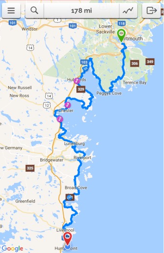
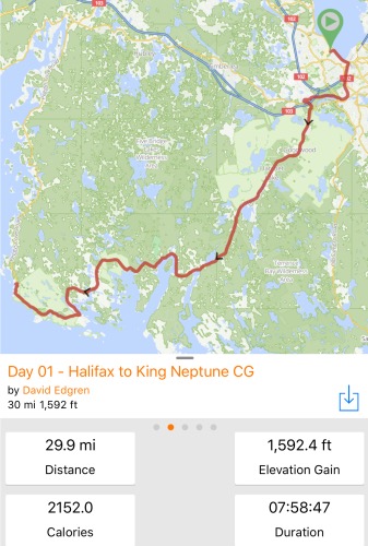
The pain in my neck at that point did not seem to be getting any better, but it also did not seem to be getting any worse. I said thank you to the various motorists who had by now stopped and offered assistance and decided to ride on for a while and see how I felt. So I rode about 10 miles/16 Km further from that point before deciding, out of an abundance of caution, to find a motel and stop early for the night. Within a short distance of making that decision the Atlantica Hotel beckoned.

image

Wheel full 70px The desk staff there was very sympathetic and concerned.  When I convinced them that, no, I didn’t need to go straight to a hospital and, yes, all I needed was just a room with a comfortable bed for the night, I was given one at what I am sure was a substantial discount, as it turns out the Atlantica is quite the fashionable resort property. But that’s story for another time.

Wheel full 70px I contacted Heather and informed her of what had happened.  I told her that I planned pretty much to head for bed and rest through to the next morning. I said that if my neck didn’t feel any better today or I awoke with other issues, I would head for a hospital.

Wheel full 70px And today I feel fine. Oh, there’s a little residual twinginess,  but it’s nothing I can’t deal with him and it’s not the kind that makes me apprehensive that something has really gone wrong and it’s just waiting to do me in. So my ride continues. I have tons of great pictures and a lot of route information to post, but that is dependent on a fast Internet connection wherever I spend the night. I’m at a Provincial Park tonight, so finding one is not all that likely. But I will be back on track, posting-wise, within the next few days.

Weigh-in #8 – Three Two Six!

…and he seeketh for a scale, and he looketh and looketh, and lo, he findeth one…

Wheel full 70px I found a medical clinic in Chester, Nova Scotia about 15 minutes into my ride this morning. The kind lady at reception, when I said I was weighing once a week, stopped me there and said she’d show me where the scale was.

Wheel full 70px It was an older beam and sliding weight scale. When I was over 350, which was all of the last ten years plus, I couldn’t use these because they max out there.

Wheel full 70px Not today!

image

Wheel full 70px It was a little awkward.  I forgot my iPhone, which was charging at the Subway a few doors down, so had to use the Canon.  Trying to position the shot shook the scale and everything started bouncing up and down.  I couldn’t get an angle that included me.  But with everything settled down, I weighed 326 pounds/~148 kg.  Wow!

Wheel full 70px Next week should be interesting.

Day Two – Made It

Wheel full 70px Here I am at Hubbard’s Beach Campgroud after an almost 29 mile/47 km ride yesterday that was surprisingly challenging around St. Margaret’s Bay.

image

Wheel full 70px The RidewithGPS link is here [linkie].

Wheel full 70px I guess I should note that this was after a 5 mile/8 km round trip early in the morning into the village of Peggy’s Cove, so that bumps my mileage up a little bit.  The Peggy’s Cove ride will be the subject of a separate post probably tonight.

Wheel full 70px The total elevation gain yesterday turned out to be significantly more that it was a day one of the ride. So much for trusting the RidewithGPS estimate that it makes when you plan out the route.   Or, it could be that the altimeter readings as I’m riding along are not accurate, I don’t know.  What it certainly is in any event is that where the rubber meets the road there were a ton of PUDS (pointless ups and downs)  the first half of the ride up the east side of the bay.  A crest of 100 feet/30 meters might look like a little bump on the elevation profile,  but it’s like riding your bike to the top of the 10 story building. Think about that. Now think about doing it over and over again maybe four or five times in an hour.  Uggggggh!

Wheel full 70px When I reached Provincial Route 3 at Upper Tantallon both the grades and hills leveled out significantly.   The lanes were no wider, but there were better site distances. Today, though, I’ll return to the local roads and so will lose that advantage.

Wheel full 70px Strava was still crapped out yesterday.

image

I deleted and reinstalled the app last night and we’ll try it again today.  We’ll see.

Wheel full 70px Oh, and I almost forgot a teaser.

image

Wheel full 70px Have a great Sunday, wherever you are.

Day 1 – Made it

Wheel full 70px Just a short post without photos or much description to let you know I made it on the first day of my ride to my goal: King Neptune Campground in Indian Cove, Nova Scotia.  I plan to write a detailed post with pictures and description for each day when I have some leisure time. Here’s the RidewithGPS information for yesterday.

image

Wheel full 70px The RidewithGPS link is here [linkie].

Wheel full 70px A couple of things from yesterday.   I was out the door and checked out of my room by 10, cleared the grocery store  where I bought some supplies for the day by 11 and was out of Halifax proper by about noon. All in all, I rode about three hours out of the eight I was on the road, averaging just under 10 miles an hour.  My overall average speed has improved about a mile an hour since I started riding with gear just a few short days ago.

Wheel full 70px I spent another two hour’s stop at Shaw’s Restaurant in West Dover  about 10 miles from my final destination eating an amazing dinner and sitting on a deck looking at even more amazing scenery.  Shaw’s will get a post of its own coming up.

Wheel full 70px By the time I left Shaw’s the sun was getting fairly low in the sky’s. Because some clouds have moved in it was getting darker  then I cared that it would be on a fairly busy road, so I skipped Peggy’s Cove and rolled onto the campground. This morning I backtracked about 2 miles leaving my gear at the campground to ride through this amazing village.   It will also get a post of its own.

Wheel full 70px While RidewithGPS hung in there, a couple of things didn’t work yesterday.   Strava crapped out and completely reset itself about 5 miles into the ride. I tried for a little bit, but nothing I had done was recoverable. I now feel rewarded for using both Strava and RidewithGPS even though it is kind of a “belt and suspenders” approach.  My Scosche heart rate monitor also appears to have died.  I had fully charged it the night before I left, but I was unable to ever synch it and it appears to be kaput.  I’ll look at it more carefully when I have some time, but I don’t have a lot of hope.

Wheel full 70px I said no pictures? Well, I can’t leave you without this teaser.   It just wouldn’t be fair.

image

Wheel full 70px Day 2 awaits!