The Ride – Take 2, Day 1

Wheel full 70px I’m going to take a nice easy day along the coast southeast of Halifax.

image

Wheel full 70px This is an extraordinarily scenic stretch and it looks like I’ll have perfect riding weather.

image

Wheel full 70px Right before I stop for the day I’ll cruise through Peggy’s Cove, which is the archetypical tiny Nova Scotia fishing village.

image

I should have ample time to look around.  Film at 11.

Wheel full 70px Oh, and…

Greetings from Nova Scotia

A great Halifax bike shop

Wheel full 70px I’d be seriously remiss if I departed Halifax on my trip without mentioning Bikes by Dave [linkie], a local bike shop that I stopped at on Monday to get the Surly checked over and to ask a couple of questions that I had.

image

Wheel full 70px When I called to set up a time to come in I was told that there was a several day wait for service but after I explained a little about my trip I was told to come on over, as they were always happy to make a little room on the schedule for someone on a long-distance tour.

imageimage

Wheel full 70px When I arrived, Tom, the shop’s mechanic, quickly and efficiently went over the bike, addressed my questions and concerns, and made several helpful recommendations concerning my route down Nova Scotia’s southwest coast. It was obvious during the 30 minutes or so that I was there that, if anything, the info about being busy was an understatement. It was a busy shop, that’s for sure.

image

Dave

Wheel full 70px When the bike was ready Dave Marder, the owner, rang up what I thought was a very reasonable amount for the time Tom spent.  If I lived in Halifax, I know where I’d take my bike to get worked on.

Day 0.1 – The Sambro Loop

Wheel full 70px I had a great ride today.  Thirty-five point six miles/57 km around roads that form a loop along the coast and back south of Halifax.  Here’s the ride on Strava.

image

Wheel full 70px Even with the onboard power my iPhone was running on fumes when I got back.

Wheel full 70px Note to self:  Do not forget the high capacity battery the next time.

Wheel full 70px I think, on a very hilly route like this one, the onboard power can only be relied upon to slow the rate of decline of my iPhone’s battery.  It does not produce power when the speed of the bike is less than 6 miles/10 km per hour.    I spent a lot of time today just creeping up hills, and there were a lot of those.

image

Wheel full 70px When I was looking at through hiking the Appalachian Trail, I learned that on an elevation profile like this the hills were called PUDS, for “Pointless Ups And Downs.”  Even though I reached speeds of 35 miles/55 km per hour on some of the downhills, gravity, the nemesis of every fat guy, kept me from gaining any sort of advantage on the next uphill grade.  In fact, I think that deserves a law which I’ll call for convenience Edgren’s law: For a fat guy on a bicycle, gravity trumps inertia every time.

Wheel full 70px But enough of that.  Per Strava, here’s the stats.

image

Wheel full 70px I’m not proud of the time.  In my defense, though, it was lightly raining about half the ride and the road was often wet and potentially slippery. I’m not doing this to present a safety hazard to myself or others. But, to be candid, that’s not really the reason I was going so slow. If I could’ve gone faster I would’ve, but I just don’t have my road legs yet.  A couple of the hills were grades of over 10%, and I was happy just to make it to the top in any gear at any speed.   But others should’ve been easy and weren’t.  I know this will get better with time, but it’s frustrating.

Wheel full 70px On the positive side, 1,920 calories burned!  That ought to help the  weigh-in tomorrow.   I just wasn’t very hungry today, and so food consisted of a 300 gram/a little more than a quarter of a pound block of medium cheddar cheese and a pepperoni stick, washed down with two 20 ounce/591 ml Gatorades over the course of the afternoon.  When I plugged the data in MyFitnessPal and hit the close out the day button, I was amused to see this.

image

Wheel full 70px Well, I guess I can dream.

Wheel full 70px I texted with Heather right after I returned and she wanted me to do the blood pressure, pulse, O2 sat and blood sugar measurements I had promised I would take regularly before I left.  You might recall that all my BP and diabetes meds have been stopped by the various docs.  Here’s what we learned.

Blood Pressure

image

O Sat

image

Blood Sugar

image

Wheel full 70px What can I say? These numbers aren’t flukes. They are entirely consistent with what I’ve been getting since I got my dietary habits under control and began a regular program of exercise. My O sats are the one thing I can’t do much about in the short run because it will take a good while for regular deep breathing to recondition my flabby lungs and chest muscles. But I believe I can do these things, along with riding my bike a very long way, along with being in some of my favorite places in the world as I ride along. As I’ve noted, I’ve never successfully focused on my health as a volitional act. I’ve found out that I can and the results to date are very encouraging.

Wheel full 70px Another Haifax city ride tomorrow with my fingers crossed that my meds will arrive, probably including a stop at a bike shop for a look over before the bike and I hit the road. I’ll also need to find a place to do the Monday weigh-in. I’ll post the couple of photos I took on the Sambro Loop ride later today.

David Edgren

Halifax!

Wheel full 70px For various reasons I won’t take the time to go into here I didn’t get my bike out and on the road ’til late yesterday afternoon with only a couple of daylight hours left.

Wheel full 70px 
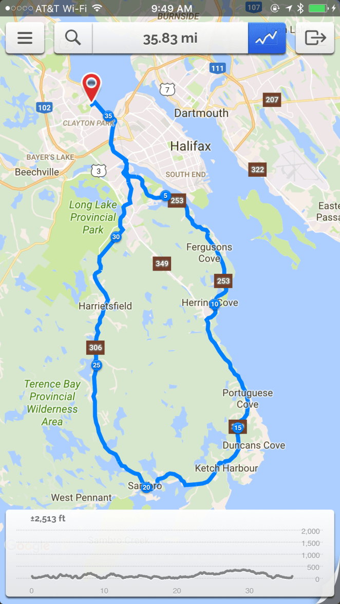
But I did get going and wound up taking a very nice 9+ mile/15 km ride along the waterfront of Halifax, an old port city that is Nova Scotia’s largest metropolis at just under 300,000 residents.  That makes it just about the same size as Anchorage, Alaska- a very comfortable size as far as I’m concerned.

Wheel full 70px 
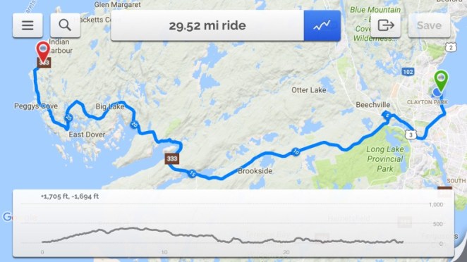
Here’s the Strava map of the ride.

image

Wheel full 70px The entire loop took me about an hour and thirty minutes, but stopping to take photos accounted for about 40 minutes worth of that.  Per RidewithGPS I averaged 10.8 miles/~18 km per hour.  The steepest grade on the ride was 7.8 percent and I believe that.  Along the waterfront the ride was a rolling one, up and down small hills.  As soon as you left that area, though, you immediately had to climb up the long ridge that the city straddles.  I climbed 150 feet/45 meter in elevation in about a quarter mile/475 meter meters, and then another 50 feet/15 meters at a lesser grade.  No parking lot rides here.

Wheel full 70px I am unashamedly an infrastructure geek.  A lot of times I’ll miss taking a picture of a historic building because I am busy looking at a bridge or an interesting freeway interchange.  I’ll also admit to being a big advocate for building high capacity roads where they are needed, period.  I am not particularly sympathetic to NIMBY opposition to these facilities, so if you catch me complaining about missing freeway links as we travel down the coast, keep that in mind.  I’m otherwise harmless, and am also a big advocate of building dedicated bicycle facilities.  I do not believe that urban governments discharge their obligation to the cycling community by painting some lines and bicycle outlines on a few unconnected busy streets, either.  But I’ll revisit that rant on another day.

Wheel full 70px Here’s some pics, taken in sequential order as I ride along.

image

Wheel full 70px Along Bedford Road at the base of the hill where my accomodations are located.  Halifax’s once busy railyards are located here, rusting tracks overgrown with weeds.  A great place for a new divided highway paralleled by a bike trail.

image

Wheel full 70px And suddenly I am on a freeway!  Halifax has a number of unconnected freeway segments that come up on the unwary bicyclist without warning.  I’ll note that I have the latest bike map prepared by the local government and there is no way around this stretch.

image

Wheel full 70px It really got pretty bad.  There appears to be plenty of room to build a bike trail here.

I will say that the drivers here appear, almost without exception, to be patient and courteous.  That really helps.

image

Wheel full 70px The first of the two big suspension bridges- the two “Macs”- across the Halifax Narrows comes into view.  This is the Mackay Bridge.

image

Wheel full 70px 
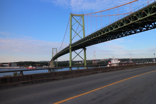
It’s big pretty bridge, very easy on the eyes.

image

Wheel full 70px It could use a paint job though.  As a great Canadian once said, “Rust never sleeps,” folks.

image

Wheel full 70px 
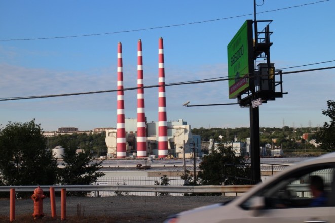
The municipal power plant is right on this busy industrial waterway.

image

Wheel full 70px Is that a ship or a circus?  You decide.

image

Wheel full 70px I’m guessing that this is the shipyard area.

image

Wheel full 70px The waterfront road approaches the downtown. Little did I know this turns into another freeway segment without any warning.

image

Wheel full 70px 
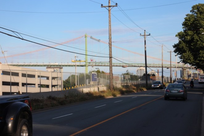
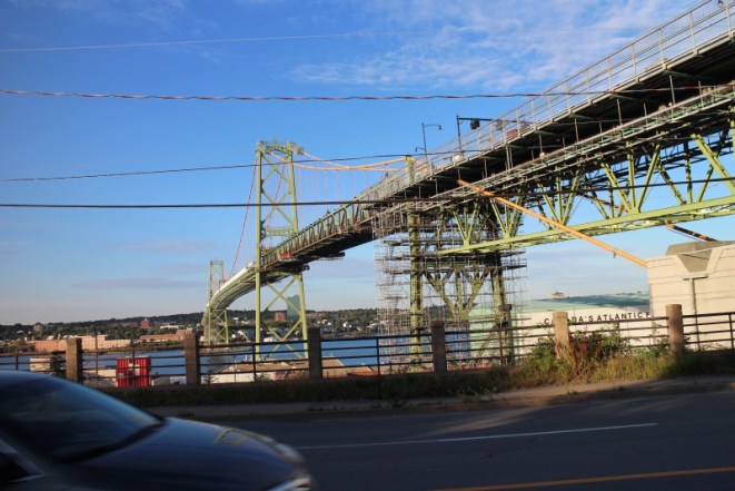
The second Mac comes into view- the Angus MacDonald bridge.  This structure is much older that the Mackay bridge, but that is not apparent until you get up fairly close.

image

Wheel full 70px 
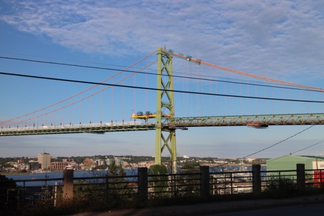
Even while being, for all intents and purposes, rebuilt, the MacDonald is another magnificent piece of the built environment.  To me, a big bridge is a symbol of the human desire to not be bound in and restrained by barriers, whether manmade or natural.  We always want to be able to get to the other side, whatever the other side might be.  Bridges let us do that, and it is just gravy that they can be beautiful while performing that function for us.

image

Wheel full 70px This is major construction.  Probably, given the state of the rest of the freeway and road infrastructure here, the result of years of deferred maintenance.  A lot of the transportation infrastructure in Halifax looks, without intention to be mean, like it was imported in bits and pieces from Mexico after it became worn out there and then was not very skillfully reassembled.  To give credit where credit is due, though, the new stuff looks pretty good.  There’s just not very much of it.

image

Wheel full 70px I bet it’ll look great when it’s done.  A parallel bridge is needed, though, as the MacDonald only carries three lanes of traffic, and there is no room to divide them.  On the bus ride from the airport I crossed this bridge and it was bumper to bumper both ways from the approaches all the way across.

image

Wheel full 70px 
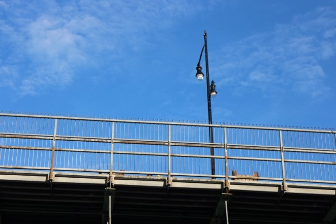
Lighting on the MacDonald.  God love our neighbors to the north- they are so civilized.

image

Wheel full 70px Once under the second of the Macs, the downtown looms.

image

Wheel full 70px 
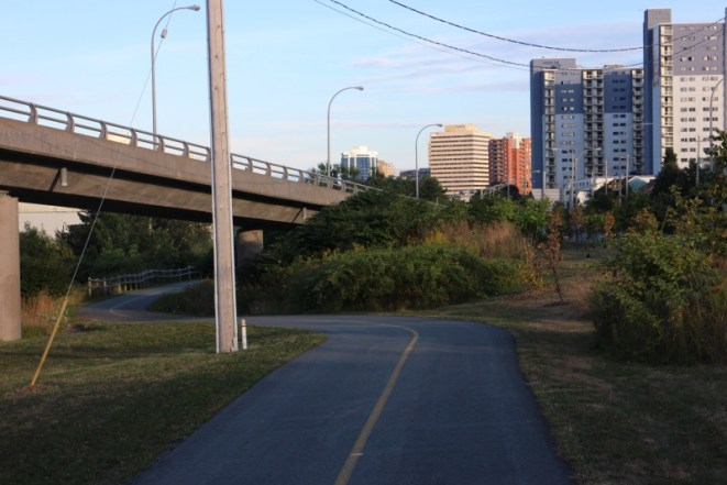
A bike trail appears, which as I found out, goes around a depressed below grade freeway section of the waterfront road.

image

Wheel full 70px The bike path suddenly disappears dumping me onto a sidewalk. It is very poorly signed.  If you don’t know where it is, you wouldn’t find it.  So I decide to head up the hill into the center of Halifax.

image

Wheel full 70px Looking down from just a short way up- and I mean UP- I notice that it’s getting dark and I have as far to go back as I have come.

image

Wheel full 70px The road passes a hill marked on the map as “Citadel” so I turn and ride around its base.  The structure on the right side of the road is the city clock tower.

image

Wheel full 70px 
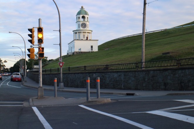
A closer view.  You get a good sense here of the extreme grade up the hill to the Citadel area.

image

Wheel full 70px The clock tower perches at the bottom of the hill.  I was not tempted in the least to walk my bike up the path and see the top.

image

Wheel full 70px 
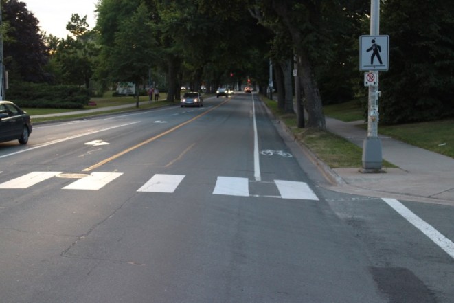
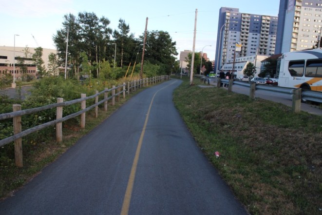
A last photo on the way back, which I pretty much zoomed through without stopping.  There are dedicated bike lanes in Halifax.  Like the freeways, though, they do not connect up into a holistically conceived system.  As such, they are nice for where they are at, but pretty worthless from the standpoint of safely bicycling in the city.

Wheel full 70px If my meds aren’t here Monday, we may do this again with an earlier start.

My SAG Team

Wheel full 70px While this is a solo bike trip, in that I’ll be riding alone and do not have a support vehicle traveling with me, I do have a SAG (support and gear) crew helping me along the road from home in Alaska about 5,000 miles/8,000 km away.

image

Wheel full 70px My wife Heather and her mom Frankie are there for me every day over the phone and by text and email with words of encouragement, advice and news from Alaska.  They are taking care of the things at home that I can’t while I’m gone and are there when I need things mailed to me, like refills of meds, along the way.  Frankie came all the way up from her home in Tennessee to stay with Heather and do this with her.

Wheel full 70px Heather and Frankie make the best support crew I could ask for and I know I owe each a great deal for their willingness to be a big part of my b2b trip.

Which way did it go…?

image

Wheel full 70px Well, that’s not a Trek bike in that box in any event.

image

Wheel full 70px So, oh momma, can this really be the end?

Wheel full 70px Is it really all over?  Am I headed back to Alaska?  After all that prep, am I done after only riding 60 miles/105 km?

Wheel full 70px Or am I headed for the next level?  Just keep in mind what Treebeard said (in the movie at least):

I always like going South; somehow it feels like going downhill.

Wheel full 70px So, wherever you go, there you are.  And we’ll see where we are in just a few days.

David Edgren

Weigh-In #5 – It must have been the pizza

Wheel full 70px Well, sometimes you just can’t win.  After eating a 1,500 calorie a day low-carb, no fat, no salt, no fun diet in the hospital for much of four days this past week, I gained weight.

image

Wheel full 70px I’m up five pounds since last Monday.  I had on street clothes this time while on the scale- a pound extra, maybe- but I’d really hoped to make it in to the 330s.  Maybe this scale, which was in the ER at Bayfront Hospital in Spring Hill, Florida, was off by a bit.  Maybe not.

Wheel full 70px But next week we’ll do it again, and see.

It’s Deja Vu All Over Again

image

Wheel full 70px So, damn it.  Here we go again.

Wheel full 70px If you’ve been following along with this blog, you’ll know that I was admitted to the hospital the weekend before I left for Florida.  That admission was kind of a mess.   My blood pressure had fallen really low and that led to the discovery that my BP meds were probably at a dosage that was no longer needed, in that exercise and tightly controlled diet were doing the job pretty much on their own.

Wheel full 70px The problem with low blood pressure, at least for me at this point, is that it leads pretty quickly to my kidneys starting to shut down due to dehydration.  That process was reversed during the three days I was in the hospital through IV hydration, and we thought we had addressed the problem by cutting in half the dosage of one of my BP meds.

Wheel full 70px But not so fast.

Wheel full 70px Wednesday of this week was a really great day for me, ride-wise.  I met both of my goals- ten miles an hour and forty miles total for the day.  My legs were strong at the end of the day.  Even though it was very hot- near 100 degrees- I felt good throughout the ride.  I’ve described elsewhere the glitch as far as not having a place to stay when I arrived in Lake Butler, but that wasn’t really a big deal.

Wheel full 70px So on Thursday everything seemed to be going OK.  I did notice that I seemed to be moving along somewhat slowly as I packed up for the day’s ride, but  I chalked that up to my first night camping instead of sleeping in a bed.

Wheel full 70px As soon as I got on the bike, though, it was apparent that something was up.  I felt weak and wobbly from the first push on the pedals.  My immediate inclination was to stop and get something to eat, as I had not been hungry before I went to bed the previous evening.

image

Wheel full 70px There was a handy pizza stand right next to where I had camped, so I had the nice Pizza Maiden make me one, which I then sat outside and ate.

image

Wheel full 70px One pizza later I got back on the bike.  After riding about a mile, I called a halt.  I didn’t feel steady on the bike (even with all that pizza weighing me down) and I was worried about being at risk on the busy road on which I was traveling.  I stopped, leaned my bike up against a sign, and sat down on one of those above-ground utility cabinets.  Nice folks brought me out some cool water from a nearby apartment building.  When I couldn’t pull it together after sitting for a while the local rescue squad was called and I was off to the North Florida Regional Medical Center in Gainesville.

image

Wheel full 70px And, as I said back at the beginning, it’s deja vu all over again.  My blood pressure is low.  I’m dehydrated (despite drinking enough Gatorade on Wednesday to float a battleship).  My kidneys are crying “uncle!”  I’m back tethered to an IV pole.

Wheel full 70px The recommendations this time around go even further than last time.  Stop both the Azor (which had already been reduced by half) and the Bystolic altogether.  Wait at least two weeks before resuming my trip.  Oh, and find somewhere other than Florida to resume it in.  Antarctica, I guess.

Wheel full 70px So I’m really pretty down at this point.  I have already hugely modified the trip from what I had originally planned.  I now need to ask my wife and her mom to do without me for another two weeks.  Relocating the start of the trip to somewhere meaningfully more temperate will cost at least $500 and probably more in airfare and bike teardown/shipment/reassembly.  And I have only packed one pair of non-bicycling underwear.

Wheel full 70px Well, OK.  The last one may verge into whining.  But I guess it’s either that, or cause my kidneys to fail, or just fly home.  At what point does audacity turn to folly?  I guess I’m about to find out.