Closer, closer…

  days left to go!

Wheel full 70pxWe’ve updated our itinerary, probably for the last time except for last minute adjustments.  Here’s what it looks like.

Friday, August 25 – Day 00 – Lake Itasca State Park, MN (0) – Camp
Saturday, August 26 – Day 01 – Lake Itasca State Park, MN to Cass Lake, MN (55.2) – Stony Point Resort (Camp)
Sunday, August 27 – Day 02 – Cass Lake, MN to Deer River, MN (106.4) – No nearby campground or Warmshowers host (Camp)
Monday, August 28 – Day 03 – Deer River, MN to Jacobsen Campground, MN (152.2) – Jacobsen Campground (Camp)
Tuesday, August 29 – Day 04 – Jacobsen Campground, MN to Aitkin, MN (200.3) – Aitken Campground (Camp)
Wednesday, August 30 – Day 05 – Aitkin, MN to Crow Wing State Park, MN (255.3) – Crow Wing SP Campground (Camp)
Thursday, August 31 – Day 06 – Crow Wing State Park, MN to Sauk Rapids, MN (317.3) – Residence

Friday, September 1 – Day 07 – REST DAY (Sauk Rapids, MN) – Residence Continue reading

See, I Told You I’d Be Here Today

WI Master 400px days to go!

Wheel full 70pxMy itinerary has me leaving Anchorage the morning of the 24th, arriving in Minneapolis late that evening and meeting up with a long-time family friend.  We will overnight near St. Cloud at one of her children’s residence, then leave on the 25th and drive the 150 miles/240 kilometers to Bemidji, Minnesota, the closest town of any size to Lake Itasca.  There, I will go to the Northern Cycle bicycle shop [link], where the good folks there will have assembled and checked out my beloved Surly Disc Trucker.

img_3583

Continue reading

And the Countdown Begins…

Wheel full 70pxHey, I’m back, and only have

MN-20_400x400

days to go before b2b 2017 – the brook to bayou ride starts at Lake Itasca in northern Minnesota on the 26th.  I have lots of things to share with you over the next couple of weeks before the trip starts, so I’ve plugged the blog back in again

Plugging In 800px

and should be posting pretty much every day from this point on.

Wheel full 70pxThanks for tuning back in.  I’m looking forward to getting on the road.

David

“brook2bayou” – More Prep

Example for FB and Blog 800px

Wheel full 70pxOK, so the b2b Mississippi River ride- “brook2bayou” journal on crazyguyonabike is starting to take shape.  Today I’m uploading detailed scaled elevation profiles based on 25 mile (40 km) GPX tracks created online on an awesome site- GPSVisualizer.com [linkie]. The first 500 miles are up [linkie] and I hope to have the rest done by this evening. Next step, detailed cue sheets- I’m going to know the name of every stream I cross and lake I pass if it kills me.

They Just aren’t the Same

apples ≠ oranges

Wheel full 70pxI’m spending the day doing hand-built detailed elevation profiles for the Mississippi River ride on a website called GPS Visualizer.  Both RidewithGPS and the Google Maps API will automatically create profiles from a route, but for the reason I will explain here I find them about useless for anything other than quick general info.

Wheel full 70pxHere’s why.  The next two images are greatly reduced Google Maps of two of the 50 mile/80 km days I have broken the entire 2,250 mile/3,621 kilometer route into.

Wheel full 70pxIf you look to the last 25 miles/40 kilometers of each day’s elevation chart you will see a what appears to be a honkin’ big hill in about the same place each day.  Note that the x-axis “Distance” of each chart is exactly the same length- 50 miles/80 km.  If that’s as far as you look, though, you are left with a sense that each day there will be quite a challenge right after lunchtime.  A closer look, though, discloses that the y-axis “Elevation” of each chart, even though appearing to be divided into equal units, could not be much less comparable.  The elevation “window” of the day on the left is about 400 feet/122 meters.  The day on the right is about 40 feet/12 meters.

image

Wheel full 70pxNow, I know that the folks at Google Maps and at RidewithGPS aren’t trying to mislead or confuse me.  I’m sure that there are considerations that cause the charts to be created the way that they appear, and that in fact most everyone takes away useful info when they look at them.  But here’s the two GPS Visualizer charts for the last 25 miles/40 kilometers of each day with the Elevation axis using the same measurement units.  First, the one that we know has the truly monster hill.

018-S St. Paul to Hager City Mile 0025 to 0050 800px

That clearly is going to present a challenge.  The second chart…

082-vic New Roads to South Baton Rouge Mile 0025 to 0050 800px

Not so much, eh?

It’s Just This Little Chromium Switch Here…

Wheel full 70pxTime to plug things back in.

Plugging In 800px

Wheel full 70pxWell hey there!  Nice to see you again.  And…

Greetings from Alaska 800px

Wheel full 70pxA little less than a year ago I made my first post on b2bbiketrip.com.  A lot of pavement has passed under my wheels since then.  But you all know that from previous posts here.

Wheel full 70pxI’m journaling my Halifax, Nova Scotia to Key West, Florida at the website crazyguyonabike.com [linkie].  I’ve been working on my journal there since just before Christmas. There’s about 1,500 photos posted there so far and detailed accounts, again so far, of my days riding between Halifax and Yarmouth, Nova Scotia. Here’s a [linkie] to the day I arrived in Yarmouth, and you can work backwards east from there.  Pictures are up all the way through Acadia National Park, and I’m planning to put a bunch more up shortly.  I don’t plan, given this effort, to post anything else about last year’s trip here.  Rather, I will use this blog to document this year’s planned rides, which are:

  • Palmer, Alaska to Chena Hot Springs, Alaska, planned for June 22nd through June 30th

Palmer-Chena Hot Springs RwGPS 800px

This will be 390 miles/625 kilometers in six days with a good friend.  We’ll be self-supported and camping, with our wives driving up to pick us up at the hot springs campground at the end.  Grades are pretty gentle except for  a few places south of Denali National Park and between Nenana and Fairbanks.  Here’s a [linkie] to the RidewithGPS route.

  • Lake Itasca, Minnesota to Venice, Louisiana, planned for August 24th through October 18th

Mississippi River Trip RwGPS 800px

This is the big deal ride for the year:  2,250 miles/3,620 kilometers in 52 days.  I’ll be riding unsupported by myself, except that I invite anyone and everyone who would like to ride any portion of the route to let me know.  The more the merrier.  I plan to camp with one or two motel stops each week, either of which would become WarmShowers [linkie] stays if one is available, and buy food along the way instead of cook- a plan that worked for me really well last fall.  As I’ve noted elsewhere the route is downhill (mostly) all the way.  Here’s the [linkie] to the route mapping I’ve done in a preliminary journal started on the crazyguyonabike siteA daily itinerary, which is a work in process and which I am updating every few days, is at this [linkie].

Wheel full 70pxSo thanks for your patience in waiting for me to resurface.  I look forward to keeping up whatever standards I had previously set in this blog, which was modestly successful due to your interest.  I also look forward to reading and responding to your comments, and thanks in advance for making them.

Wheel full 70pxHere’s a last photo, taken yesterday, which should give you an idea of what I’ve been doing away from the computer.

Bike at Shop in Palmer 650px

Weigh-in #19 and 3/7 – And the answer is…

img_3695

Wheel full 70px I took a couple of days off from blogging after reaching Key West, so we’ll resume by my keeping not one but two promises.  I said here [linkie] that I would do one final trip weigh-in on the 10th in KW to give me a close the record number.  I did that, stopping at a handy Publix on the way back to the hotel from Mallory Square.  Ready?

img_3693

I missed catching my feet, but you can see their reflection on the scale, to include the hole my right foot big toe wore in my bike sock.

Wheel full 70px Two eighty-five (~129 kilograms) on the nose!  As my first official weight of this whole undertaking, noted here [linkie], was 367 pounds and change/166 kg, I have lost somewhere in the neighborhood of 80 pounds/~37 kg over the past four months.  Now, I’ve learned that scales along the trip have not been exactly measuring atomic weight to six digits after the decimal point, but hey, I’ll take “the mid-280s” as a solid start point from which to defend The Battle of the Bulge.  Maybe I can even stay on the offensive.  Stranger things- anyone up for a 3,500 mile/5,600 kilometer bike ride?- have been known to happen.  Oh, and I think my friend Fred won the “Guess My End Weight” contest.

Wheel full 70px The second promise is a little harder to keep.  OK, OK, it’s a lot harder to keep.  But I said I’d do it here, so here goes.

Wheel full 70px You’ll remember that this trip was originally going to start in Jacksonville, Florida.  On the first day just before leaving I walked myself into a bathroom and took a selfie of my stomach flab.  I cautioned folks then that it wasn’t pretty.  I said that I would take a comparable pic at the end of the ride, and we’d see what happened [linkie].  Once again, you’ve been warned.

img_3694

Wheel full 70px So, for the not-faint-of-heart, here’s what my abdominal area looked like in late July

before [linkie]

and what the same area looks like now

after [linkie].

Wheel full 70px Belly fat is not pretty.  I don’t know if what mine looks like will ever improve beyond this point, or if I’m just condemned to look like Jabba the Hutt’s third cousin down there for the rest of my life.  But my waist size in pants has gone from 56″/142 cm to 46″/117 cm.

img_3691

Wheel full 70px I’ll take that.

The last day – Key West!

Wheel full 70px I will always remember November 10, 2016.  It was the day I completed riding a bicycle from Halifax, Nova Scotia to Key West, Florida, but that’s not why.  It was the day Leonard Cohen died.

img_3618

“I came so far for beauty
I left so much behind”

Wheel full 70px My wife Heather told me when we talked by phone that evening.  I had ridden back from Mallory Square to the hotel where I would spend the first night in 84 days that I didn’t have to leave from in the morning and ride a bicycle 40 miles/65 kilometers or so.  I’ve felt pretty sad and subdued every since, but that is now changing into a sense of wonder and appreciation for the amazing body of music he left us.  I won’t dwell on this further, except to say how lucky I am to have lived during his time among us.

image-56

Wheel full 70px I have now travelled by bike, more or less, the length of the line between the start and end point on this map.  The distance, which I will look at more closely once I am back to a desktop computer, is a little over 3,600 miles/5,800 kilometers, but that includes a number of ferry rides and the van ride across the Chesapeake Bay Bridge Tunnel.  I plan to publish detailed information about the ride, to include what I believe to be the exact final mileage, in a couple of future blog posts.  It’s just too hard to do from an iPhone, even a 6 Plus, which is what I’ve carried with me.

img_3549

Wheel full 70px I rode through two Canadian provinces and 14 states along as much of their coastline as I felt I could reasonable do without having to backtrack  from places where there was no outlet except for the way I rode in.  I compromised in just a few places, mainly to avoid unpaved stretches or roads that looked “iffy” for some reason once I reached them.  I can pretty much say with confidence, though, that more than 98% of the time I was riding on the through road in each province and state that was the closest to the shore.

Wheel full 70px Here’s the ride across Florida- 600 miles/960 kilometers, which I did in 12 days.

img_3551

Wheel full 70px 
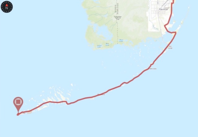
Here’s a close-up of the Florida Keys, which from Card Sound bridge to Key West was a 125 mile/200 kilometer stretch.  This took two and a half days to complete.

img_3548

Wheel full 70px When I reached Key West my sister Sue and her daughter Sarah were there to meet me.

img_3492

Wheel full 70px 
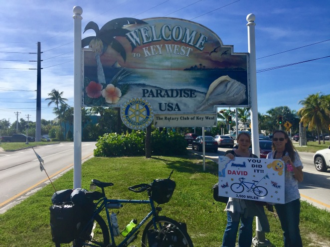
What a lift seeing them provided!  They had driven down from Sue’s home north of Tampa/St. Petersburg and will take me back up that way so that I can fly home to Alaska from Tampa next week.  When I passed them at the Key West sign, though, I still had a few more miles to go.

image

Wheel full 70px I rode on through Key West past the “Southernmost Point” monument (it really isn’t, but I’ll post about that later),

img_3585

past the end of US Highway 1, which I first saw back in Maine shortly after crossing the border from Canada,

img_3583

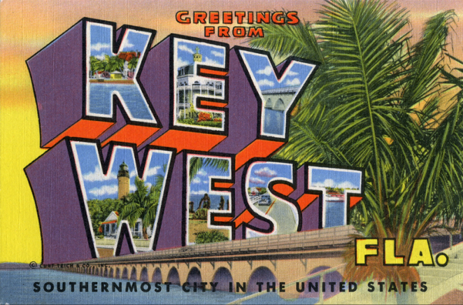
and finally to the seawall at Mallory Square.

img_3581

Wheel full 70px My ride was finally over.

img_3619 

Wheel full 70px The Surly is now reduced to parts and stuffed in the trunk of Sarah’s car.  I am headed north for the first time in three months.

Wheel full 70px I can do did this.

image-57

Last day, 35 miles to go

Wheel full 70px On August 18th when I started this trip in Halifax, Nova Scotia I had absolutely no sense of any connection to a “last day” of what has turned out to be a 3,600 mile/5,700 kilometer 84 day bicycle ride.  Key West, of course, was my destination then as it is today, but it existed back then only as a remote point on a map.  For all that it figured in my consciousness when I set out I could have just as easily been riding to Tierra del Fuego or, for that matter, the moon.

image-49

Wheel full 70px And now I’m here on the cusp of the end.  The connection has been formed, one rotation of my bike’s pedals at a time.  For whatever it is worth, I now have a string of memories that carry me at 10 miles/16 kilometers an hour down the coast of the Atlantic Ocean, past beaches and capes and rocky headlands, through farms and forests and  small towns and great cities, and punctuated by ferry rides, tent and table-top camping, and a variety of motels and other lodging, some nice, some not.  Those memories also include visits with friends and family and phone calls with my wife, as well as a lot of time just being alone with my thoughts.  It has been a great trip, and I can be satisfied that, within the context of my life to date, to the extent that I wanted to do something epic I have done just that.  I have nothing to complain about and no regrets.

img_3440

Wheel full 70px So I’m the blue dot, and in a few hours will ride the last one percent of my total mileage on the road.  That distance is a little more than five percent of my Florida miles

img_3441

and puts me about two-thirds of the way along the Florida Keys.

img_3442

Wheel full 70px My last night on the road was spent at Bahia Honda State Park, where I braved the bugs and raccoons and slept once again on a picnic table-top.

img_3439

Wheel full 70px I had ridden almost 68 miles/110 km to get here yesterday from John Pennekamp Coral Reef State Park.  That ride included crossing the Seven Mile Bridge on the Overseas Highway.

img_3446

Wheel full 70px The bridge is, in fact, seven miles/11 km from one end to the other.  How about that?  Another amazing thing on a ride that’s been full of amazing things.  And today I’ll be in Key West.

img_3474

Two days, 100 miles to go

img_3409

Wheel full 70px I’ve been on the Keys for about 15 miles/25 km now.  I have almost exactly 100 miles/160 km to go to reach Key West, and I’ll ride something more than half that in order to make it to Bahia Honda State Park, where I have a campsite reserved for the night.

img_3404

Wheel full 70px I started at John Pennekamp Coral Reef State Park, and the view from my picnic table-top bed this morning was very nice.

img_3423

Wheel full 70px Strava, after a couple of weeks of behaving, was generating garbage yesterday, so no Relive track.  I’ll try again today, but it’s hard to look past the fact that RidewithGPS has generated 82 straight days of reliable ride tracking.  Just sayin’.

Wheel full 70px Tonight’s my last night on the road. I can do this!

img_3422