 I’ll be on the Great Allegheny Passage (GAP) rail-trail for five full days starting mid-August on the 16th. This translates out, given its almost exactly 150 mile/250 kilometer length, to notional 30 mile/50 kilometer days, depending on the availability of overnight camping opportunities. As you will see, this is just about how it worked out.
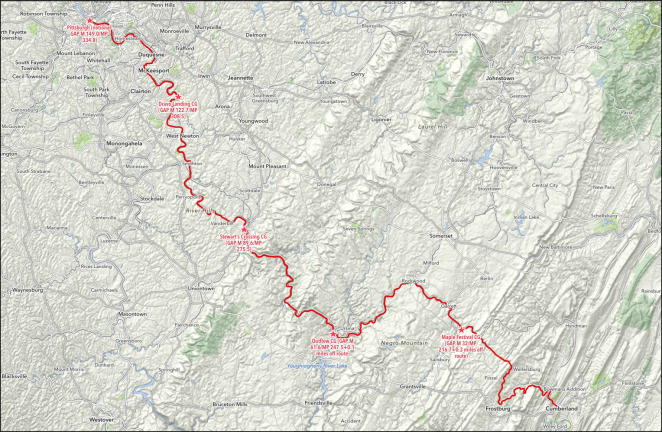
A significant difference between the GAP and the C&O Canal Towpath is that, unlike the Towpath, the GAP passes through a number of cities and towns that offer places to eat and to buy groceries and supplies. The frequency of these places grows as the trail approaches Pittsburgh. Where I might have had one opportunity in a day to eat at a restaurant or cafe along the Towpath, now I will have at the least two or three, and later along the way many more.
Day 8 – Thursday, August 16, 2018
Evitt’s Creek Hiker/Biker Campground (Mile 180.0) to Maple Festival Campground (GAP Mile 32.0/Mile 216.7+0.3 miles off route)
Four and a half miles ’til breakfast!
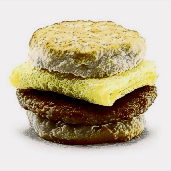
There’s a McDonald’s just off the end of the towpath in Cumberland, Maryland so I’ll be able to start my ride up the GAP properly fueled with sausage-egg biscuity goodness. I’ll take a few minutes to stop at the Visitor Center there as well, as it sounds like there’s a nice exhibit area covering the GAP and the Canal and Towpath.
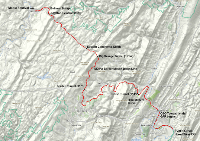
With breakfast out of the way and the end of the Towpath in my rear view mirror I will start up the GAP. And “up” in this case is very apt. For the next 23.5 miles I will climb about 1,800 feet/550 meters up to the Eastern Continental Divide, from which rivers flow to the east out to the Atlantic Ocean and to the west down to the Gulf of Mexico. When I complete this ride I will be able to say that over two seasons I will have followed that flow down to the Gulf, in that this year I will ride along the length of the Ohio River and a couple of its sources from here to Cairo, Illinois and last year I rode, as part of my ride down the length of the Mississippi River from Lake Itasca in Minnesota to Venice, Louisiana out on the delta [link], from that city out to that river’s mouth.
But back to up. I’ve addressed why this isn’t really quite all what it seems in my overview of the GAP segment [link].

The 36.8 miles/59.2 kilometers I’ll ride today will head relentlessly but gradually up for about two-third of that distance. I’m sure that I’ll be going more slowly than my usual ten mile/16 kilometer per hour pace while I’m touring, but that will just give me more time to see the really sights the day has to offer. On the way up I’ll pass Bone Cave [link], where a cut into a hillside created during the construction of the Western Maryland railroad exposed a cavern filled with prehistoric fossils, iconic Helmstetter Curve,
 Base image Credit:
914 foot/278.6 meter long Brush Tunnel, 957 foot/291.7 meter long Borden Tunnel, the Maryland Pennsylvania border and Mason-Dixon Line, and finally, just before reaching the divide, the 3,294 foot/one kilometer long Big Savage Tunnel.
I expect to reach the divide- the crest of the Appalachian Mountains in this area- around mid-afternoon. From there it will be a nice gentle downhill run the remaining eight and a half miles/13.7 kilometers into Meyersdale, Pennsylvania and the city’s Maple Festival Campground. On the way down to Meyersville I’ll cross the 909 foot/277 meter long Keystone Viaduct and the Bollman Bridge [link].
 Image credit: Library of Congress, U.S. Government work
Here’s a summary of the day’s highlights (trip mileage is second figure):
- Cumberland, Maryland/Visitor Center (GAP Mile 0/Mile 184.5)
- Bone Cave (GAP Mile 4.1/Mile 188.6)
- Helmstetter Curve (Gap Mile 5.5/Mile 190)
- Brush Tunnel (GAP Mile 6.5/Mile 191.0)
- Frostburg, Maryland/Depot and Roundtable (GAP Mile 15.7/Mile 200.2)
- Borden Tunnel (GAP Mile 17.9/Mile 202.4)
- MD-PA border/Mason-Dixon Line (GAP Mile 20.8/Mile 205.3)
- Big Savage Tunnel (GAP Mile 22.1/Mile 206.6)
- Eastern Continental Divide (GAP Mile 23.9/Mile 208.4)
- Keystone Viaduct (GAP Mile 30.0/Mile 214.5)
- Bollman Bridge (GAP Mile 30.6/Mile 215.1)
Day 9 – Friday, August 17, 2018
Maple Festival Campground (GAP Mile 32.0/Mile 216.7+0.3 miles off route) to Outflow Campground (GAP Mile 61.6/Mile 247.5+0.1 miles off route)
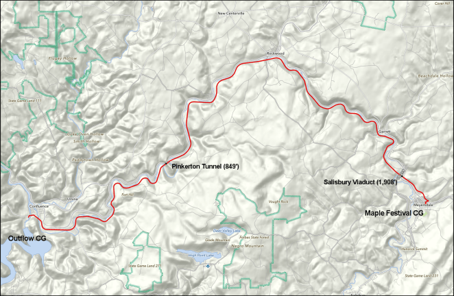
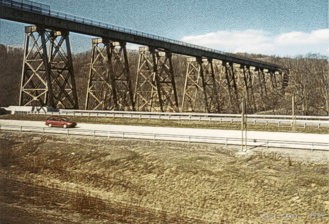
My second day riding the GAP will start with a quick look around Meyersdale and maybe a bite of breakfast if I see somewhere that appeals. I will ride all day pretty much right alongside the Casselman River to its mouth on the Youghiogheny, which I hopefully will have learned to pronounce correctly by the time I get there. A few miles out of Meyersdale I will cross the river to its south bank on the 1,908 foot/581.6 meter Salisbury Viaduct, and ride on that side the rest of the day.
 Base image credit: Public domain
I’ll pass the small towns of Garrett, Rockwood and Markleton across the Casselman: there are bridges to get to each, but I probably will just enjoy the view from the trail unless I spot or hear about something in any of them of particular interest. Sometime in the afternoon I will reach the 849 foot/258.8 meter Pinkerton Tunnel, which was restored and opened for trail use just a few years ago. Just about exactly 30 miles/50 kilometers down the GAP I will roll into the city of Confluence, Pennsylavania, where I will grab some dinner and then set up camp for the night at the Army Corps of Engineers’ Outflow Campground just after crossing the Youghiogheny for the first time.
These are today’s points of interest:
- Salisbury Viaduct (GAP Mile 33.6/Mile 218.3)
- Garrett (GAP Mile 36.6/Mile 221.3)
- Rockwood (GAP Mile 43.9/Mile 228.6)
- Markleton (GAP Mile 50.0/Mile 234.7)
- Pinkerton Tunnel (GAP Mile 51.9/Mile 236.6)
Day 10 – Saturday, August 18, 2018
Outflow Campground (GAP Mile 61.6/Mile 247.5+0.1 miles off route) to Stewart’s Crossing Hiker/Biker Campground (GAP Mile 89.6/Mile 275.5)

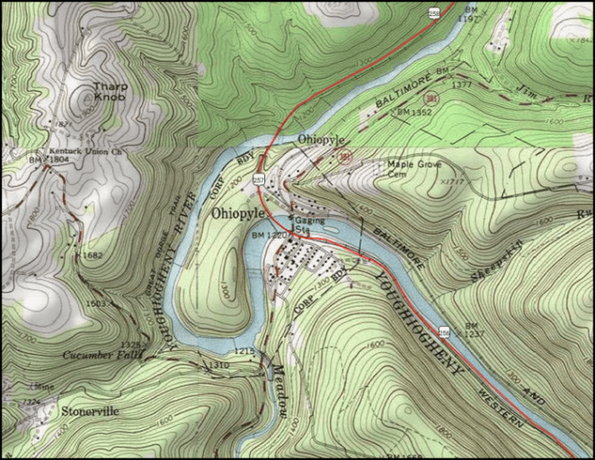
My third day riding on the GAP is also my last day in the Appalachian Mountains, more specifically here called the Alleghenies, which I will formally leave heading to the west at Connellsville, Pennsylvania, my destination for the day. The ride all day is along the west bank of the Youghiogheny River (truth be told there’s a brief foray onto the east bank just after passing through the village of Ohiopyle via the Low and High Bridges),
which I’ve learned the local folks just call the “Yock.” That’s fine with me, as who has time to learn how to pronounce Youghiogheny?
So the Yock provides some excellent scenery along this stretch, flowing in a deeply carved gorge much of the way, with just enough room alongside for the GAP and the CSX tracks on the other side of the river.
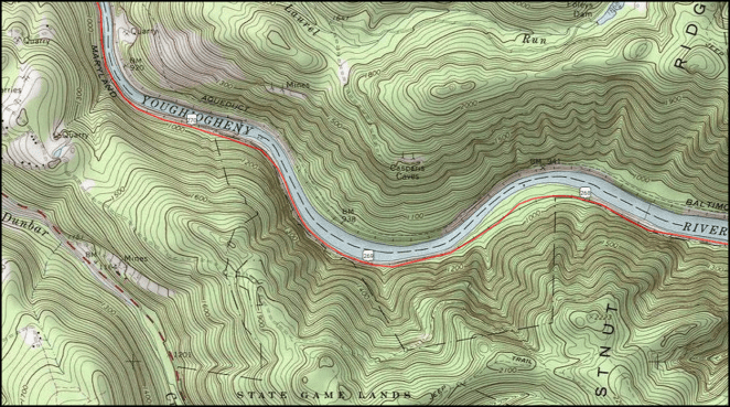

Yep. Just me, my bike, the Yock and a 200 car freight train. Just sayin’.

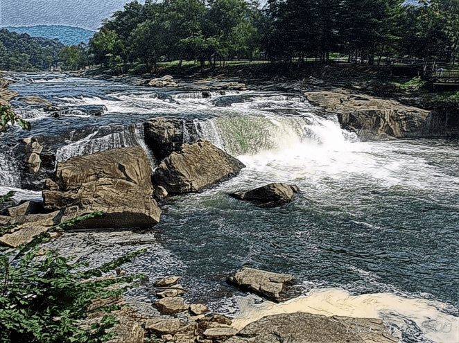
The highlight of all this beauty is Ohiopyle State Park, which is centered around the town of the same name. Hmmmm… Ohiopyle. Wonder if there’s a short name for that?

 Base image Credit:
So today’s ride should be 28.1 miles/45.2 kilometers of pure scenic pleasure. I’ll grab some breakfast in Confluence, Pennsylvania on the way out of town and then have dinner in Connellsville on the way in to my hiker/biker campground just past the city center. Particular points of interest are:
- Ohiopyle, Pennsylvania/Ohiopyle State Park (GAP Mile 70.9/Mile 256.8)
- Low Bridge (GAP Mile 71.0/Mile 256.9)
- Ferncliff Natural Area (GAP Mile 71.1/Mile 257.0)
- High Bridge (GAP Mile 71.3/Mile 257.2)
- Jonathan Run Falls trail (GAP Mile 74.3/Mile 260.2+0.2 miles off route walk)
- Sugar Run Falls trail (GAP Mile 74.4/Mile 260.3+0.2 miles off route walk)
- Yough River Gorge Overlook (GAP Mile 76.1/Mile 262.0)
- Bowest Junction/Sheepskin Rail-trail (GAP Mile 86.0/Mile 271.9)
I’ve talked with Katie at The Bike Shop in Ohiopyle [link] and she indicated that I could park my bike securely there while walking around the village and the adjacent Ferncliff Natural Area trail. You encounter the greatest folks on rides like this. My wife has pressed me to visit Frank Lloyd Wright’s architectural masterpiece Fallingwater [link], which is almost four miles off the route at Ohiopyle, but that’s unfortunately unlikely.
 Base image Credit: Public Domain
Aside from adding an additional eight miles/13 kilometers of pedaling to a day that already looks pretty busy, about a mile/1.6 kilometers of that extra riding is up a ten percent grade, and it’s almost as bad on the way back. Just to look at the place costs ten bucks, as well. So, I guess you always wind up leaving something for the next time you’re through the area. So long, Frank Lloyd Wright.
Day 11 – Sunday, August 19, 2018
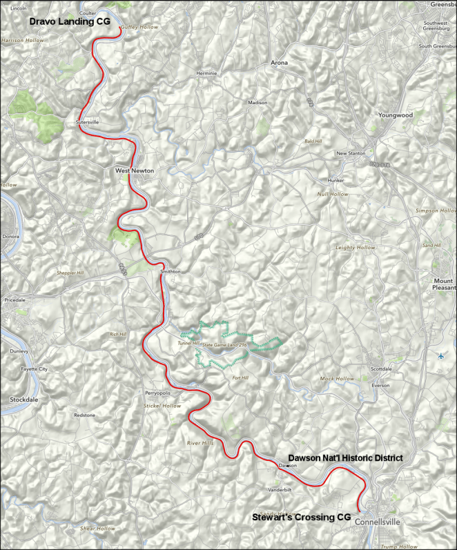
Stewart’s Crossing Hiker/Biker Campground (GAP Mile 89.6/Mile 275.5) to Dravo Landing Hiker/Biker Campground (GAP Mile 122.7/Mile 308.5)
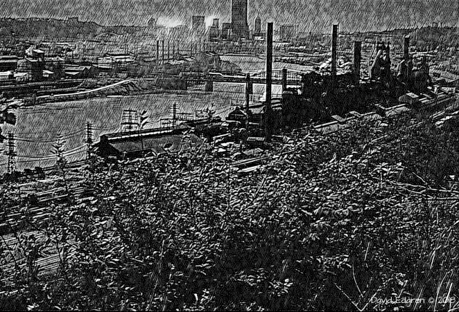
Day four on the GAP will find me out of the mountains and cycling through the heart of America’s coal country south of Pittsburgh. The mines here were largely worked out by the mid-20th century, leaving behind a lot of historical evidence, including the abandoned rail corridor that became the GAP. My 33 mile/55 kilometer ride today will start with a couple of sausage-egg biscuits at the Connellsville McDonald’s, conveniently located near the trail,
and I will then then get back to working my way up the west bank of the Yock, which I will have just over my right shoulder all day. All the little cities and towns I will ride through are former “coal patch” company towns, developed along with the mining operations to provide housing and services to the workers and owners. I’ll see the ruins of many of these mines along the trail, and the “beehive ovens” that were used to turn the coal into coke, an almost pure form of carbon that was then taken by rail down to Pittsburgh and the blast furnaces of the steel mills there.
 Image Credit: Public Domain
Mid-morning I’ll likely go briefly off-route and cross the river to look at community of Dawson, which is designated a National Historic District for its well-preserved 19th century central business district and surrounding residential area. I’ll also take a brief off-route excursion into the community of Perryopolis, which has a “wagon-wheel” central city layout designed by George Washington.

There’s also a restored grist mill built by Washington (or more likely by people who worked for him) on the road into town. I’ll take a look at that as well. Later in the day I’ll ride through West Newton, a larger city, and pick up an early supper and, if I need them, any replacement supplies I might need. I should reach the hiker/biker campground where I’ll stop for the night by mid-afternoon, which will give me time to walk around the adjacent Historic Dravo Cemetery [link], where veterans of the War of 1812 and of the Civil War are buried.
- Adelaide, Pennsylvania (GAP Mile 91.1/Mile 277.0)
- Dawson, Pennsylvania (GAP Mile 93.5/Mile 279.4+0.2 miles off route)
- Perryopolis/George Washington Mill (GAP Mile 101.0/Mile 286.9+1.2 miles off route)
- Whitsett (GAP Mile 103.1/Mile 289.0)
Day 12 – Monday, August 20, 2018
Dravo Landing Campground (GAP Mile 122.7/Mile 308.5) to Pittsburgh [notional] (GAP Mile 149.0/Mile 334.8)
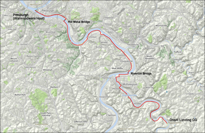
My last day on the GAP will be largely spent in the greater Pittsburgh area. The trail becomes, once I reach McKeesport, Pennsylvania, more or less an urban bike path through a predominately industrial area.

I’ll eat breakfast somewhere in McKeesport- more or less whatever I spot along the trail that looks good. The Youghiogheny Yock empties into the Monongahela River here, and I’ll be in sight of the latter and cross it several times on my way to its confluence with the Allegheny River and the beginning of the Ohio, which marks the start of the next segment of my ride.
The day, at 26.3 miles/42.3 kilometers, is the shortest mileage on the GAP and also the shortest that I have planned on the whole ride. I figure that, because the trail here is often paved, that I’ll move right along, but I hope to have some time to look around downtown Pittsburgh at the end of the day. There’ll also be plenty of post-industrial era landscape to take photos of.
 Base image Credit: Public Domain
Right before I arrive at the downtown I’ll cross the Monongahela on the Hot Metal Bridge [link], a cool artifact of a former day when Pittsburgh was the steel capital of the world. Seventy-five years ago up to 180 tons/163,000 kilograms of molten iron an hour, 24 hours a day, were carried across the Monongahela in crucibles over the bridge. Now it carries the GAP.
I’ll be staying with a Warmshowers host in Pittsburgh, so my planned end point for the day at the tip of Triangle Park at the beginning of the Ohio River is notional. I likely will ride there, take some photos, and then on to my host’s home for the night. We’ll see.
- Hot Metal Bridge (GAP Mile 144.4/Mile 330.2)
In the morning, the 20th of August, I’ll be back on pavement and starting the third segment of my ride: The Ohio River – from Pittsburgh to Cincinnati. That’ll be next coming up on the blog. Thanks for stopping by.
